 |
      |
| Home > Arizona > Apache Trail |
Apache Trail
Saturday, December 23, 2023
| Other Names | Apache Trail Loop, Tonto National Forest, Superstition Wilderness, Apache Junction, Salt River Valley, Fish Creek Hill, Canyon Lake, Apache Lake, Theodore Roosevelt Dam, Roosevelt Lake |
| Last Known Status | Open |
Apache Trail is a 200 mile mostly paved scenic byway loop that starts from Apache Junction and connects Hwy 88 to I-60 back to Apache Junction. After passing Tortilla Flat (near mile marker 23) the road turns into a well-maintained dirt road that continues for 22 miles toward Roosevelt Dam.
The Superstition Wilderness, Four Peaks Wilderness, Three Bar Wildlife Area and portions of the Tonto National Forest surround this loop, making it a very scenic drive. There are some OHV trails in this general area, but Apache Trail itself is not really an ATV or motorcycle trail, it is a road.
There are plenty of hiking and equestrian trails, camping areas, boating and rafting areas, ghost towns and numerous sightseeing opportunities.
The Tonto National Monument has guided tours of the ancient cliff dwellings of the Saledo civilization. RVs and vehicles hauling long trailers may wish to avoid this route, as there are many blind spots and narrow sections.
REGULATIONS
| Permit Required | No | street legal vehicles only |
| Dates Open | Year-Round | |
| Other ATV Stickers Accepted | No | |
| Spark Arrestor | Yes | A spark arresting exhaust silencer or end cap is required for all vehicles. |
| Noise Limit | Yes (96 dB) | |
| Whip Flags | Not Required | |
| Maximum Vehicle Width | No Restriction | |
 Motorcycles & Dirt Bikes Motorcycles & Dirt Bikes | Prohibited | street legal vehicles only |
 ATVs ATVs | Prohibited | street legal vehicles only |
 UTV & SXS UTV & SXS | Prohibited | street legal vehicles only |
 SUVs & Jeeps (registered) SUVs & Jeeps (registered) | Permitted | street legal vehicles only |
| Dune Buggy & Sand Rail 4x4 (unregistered) | Prohibited | street legal vehicles only |
| 2 Stroke Engines | Prohibited | street legal vehicles only |
| MX Helmet Required | Youth Only | required for persons under 18 by state law (RiderPlanet strongly recommends helmets for all riders.) |
 Camping Camping | Some Areas | (camp in developed sites only) |
 Campfires Campfires | Some Areas | (permitted in developed campsites only) |
| Night Riding | Yes | Not Recommended |
| Trail Blazing | Prohibited | |
| Rule Enforcement | Few/Periodic | Jeep/SUV Patrol |
TYPE OF AREA
| Area | scenic byway |
| Land | National Forest, Wilderness |
FEES & PASSES
| Parking | (None) |
| Entry | (None) |
| Riding | (None) |
| Camping | Yes Tent: $10.00 RV: $10.00 Addtl. Vehicle: $0.00 Tonto National Forest Campground Fees |
| Comment | Tonto National Forest camping fees vary from around $10/night to $40/night. Call (602) 225-5200 for current rates. |
RATINGS
| Pros | very scenic drive, plenty of boating, camping, fishing and sight seeing opportunities |
| Cons | no OHV trails, area is surrounded by wilderness and wildlife land |
| Our Rating |  Fair Fair |
| Recommended Stay | Full Day Winter/Early Spring |
| Comments | (Scroll Down For Rider Reviews & Comments) |
DRIVING DIRECTIONS
| Nearest City | Apache Juntion, AZ | ||
| From: Mesa, AZ
1) Take Hyw 89 East toward Apache Junction 2) Turn north on Hwy 89 at Apache Junction 3) This is the start of the Apache Trail 4) There is no staging area because there are NO MOTORIZED TRAILS (this area is suitable for dual sport only). |


OFFICIAL CONTACTS
| Contact Info | Tonto National Forest 2324 E. Mcdowell Road Phoenix, AZ 85006 (602) 225-5200 mailroom_r3_tonto@fs.fed.us www.fs.usda.gov |
Apache Trail Riding Area Photo
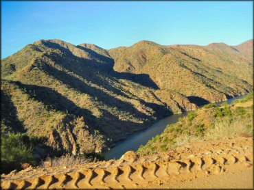
Photo Submitted 8/17/2011 (Thanks!)
Apache Trail Riding Area Photo
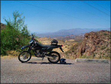
Photo Submitted 6/6/2012 (Thanks!)
ADD PHOTOS
TERRAIN
| Approx Size | 422,400 acres (660 sq mi) | |
| Climate Type | Desert | |
| Elevation | 2000 to 6000 ft. | |
| Trail Maintenance | Unknown | |
| Loose Dirt |  Little Little | |
| Hard Pack |  Mostly Mostly | |
| Sand | Little | |
| Mud |  None None | |
| Dust |  Some Some | |
| Rocks | Little | |
| Trees | Some | |
| Steep Hills | None | |
| Water Crossings | None | |
| Small Jumps | None | |
| Large Jumps | None | |
| Berms | None | |
| Sand/Gravel Pits | None | |
| Single Track | None | |
| Roads |  All All | |
| Intersections |  Many Many | |
| Rider Traffic |  Few Few | |
| Shade | Few | |
| Ranges/Gunfire | Few | |
| Hazards | Few | (hazards assumed marked but use caution) narrow sections of road with blind spots |
 Novice Novice | Mostly | |
 Amateur Amateur | Little | |
 Expert Expert | Little |
GPS POINTS


KEY SERVICES
 Gasoline Gasoline | Apache Juntion, AZ | |
| Diesel | Apache Juntion, AZ | |
 Water Water | 5-20 Miles (NE) | see map for various campground locations |
 RV Hookup RV Hookup | 5-20 Miles (NE) | see map for various RV campground locations |
 RV Disposal RV Disposal | 5-20 Miles (NE) | see map for various RV campground locations |
| Campground | 5-20 Miles (NE) | see map for various campground locations |
 Conv Store Conv Store | Apache Juntion, AZ |
RIDER COMMENTS & REVIEWS