 |
      |
| Home > Arizona > Harquahala Mountain |
Harquahala Mountain
Saturday, December 23, 2023
| Other Names | Harquahala Peak, Hassayampa Field Office |
| Last Known Status | Open |
This long 4x4 route starts at the base of Harquahala Mountain and climbs to the top and ends at the Historic Harquahala Observatory. Along the way to the mountain summit are several side spurs that lead to abandonded mines, cabin ruins and primtive camping sites.
The terrain is mostly hard packed with some rugged sections and sharp turns, but nothing too challening. All vehicle types are permitted but this trail is particulary popular with Jeeps and 4x4s. The staging area has room for trailers and has some basic amenities that consists of a vault toilet and informational kiosk. There is no fee charged to camp or ride.
The road is open year-round but is best explored during the fall, winter and spring months. It is also advised to avoid this area if there is a chance of lightning storms.
REGULATIONS
| Permit Required | Yes | AZGFD sticker required |
| Dates Open | Year-Round | |
| Other ATV Stickers Accepted | No | All non-residents must purchase an Arizona OHV decal. |
| Spark Arrestor | Yes | A spark arresting exhaust silencer or end cap is required for all vehicles. |
| Noise Limit | Yes (96 dB) | |
| Whip Flags | Not Required | |
| Maximum Vehicle Width | No Restriction | |
 Motorcycles & Dirt Bikes Motorcycles & Dirt Bikes | Permitted | |
 ATVs ATVs | Permitted | |
 UTV & SXS UTV & SXS | Permitted | |
 SUVs & Jeeps (registered) SUVs & Jeeps (registered) | Permitted | |
| Dune Buggy & Sand Rail 4x4 (unregistered) | Permitted | |
| 2 Stroke Engines | No Restriction | |
| MX Helmet Required | Youth Only | required for persons under 18 by state law (RiderPlanet strongly recommends helmets for all riders.) |
 Camping Camping | No Restriction | (camp anywhere) |
 Campfires Campfires | ||
| Night Riding | Yes | Not Recommended |
| Trail Blazing | Prohibited | stay on trails |
| Rule Enforcement |
TERRAIN
| Miles Of Trail | 26 | |
| Climate Type | Desert | |
| Elevation | 1815 to 5681 ft. | |
| Trail Maintenance | Marked, Not Rated, Lightly Maintained | |
| Loose Dirt |  Little Little | |
| Hard Pack |  Mostly Mostly | |
| Sand | Little | |
| Mud | Little | |
| Dust |  Some Some | |
| Rocks | Some | |
| Trees |  None None | |
| Steep Hills |  Few Few | |
| Water Crossings | Few | |
| Small Jumps | None | |
| Large Jumps | None | |
| Berms | None | |
| Sand/Gravel Pits | None | |
| Single Track | None | |
| Roads | Mostly | |
| Shade | None | |
| Hazards | Few | (hazards assumed marked but use caution) |
 Novice Novice | Mostly | |
 Amateur Amateur | Little | |
 Expert Expert | None |
TYPE OF AREA
| Area | Motorized Trails |
| Land | BLM |
GPS POINTS


KEY SERVICES
 Gasoline Gasoline | 5-20 Miles (N) | Woody's (928) 685-2352 |
| Diesel | 20-30 Miles (NW) | Salome Shopping Center (928) 859-3445 |
 Water Water | 5-20 Miles (NE) | Centennial Park (928) 859-4342 |
 RV Hookup RV Hookup | 20-30 Miles (NW) | Salome KOA (928) 859-4639 |
 RV Disposal RV Disposal | 20-30 Miles (NW) | Salome KOA (928) 859-4639 |
| Campground | 5-20 Miles (NW) | Centennial Park (928) 859-4342 |
 Conv Store Conv Store | 5-20 Miles (N) | Woody's (928) 685-2352 |
FEES & PASSES
| Parking | (None) |
| Entry | (None) |
| Riding | (None) |
| Camping | (None) |
RATINGS
| Our Rating |  Good Good |
| Recommended Stay | Full Day |
| Comments | (Scroll Down For Rider Reviews & Comments) |
DRIVING DIRECTIONS
| Nearest City | Aguila, AZ | ||
| Address | Eagle Eye Road, Aguila, AZ 85320 | ||
| From: Wickenburg, AZ
1) Take Hwy 60 west about 25 miles 2) Turn left (south) onto Eagle Eye Road, continue 18.4 miles 3) Turn right (north) onto Harquahala By Way, continue .1 miles 4) Staging area is on the right (east). |


OFFICIAL CONTACTS
| Contact Info | BLM - Hassayampa Field Office 21605 N. 7th Avenue Phoenix, AZ 85027-2929 (623) 580-5500 blm_az_pdoweb@blm.gov www.blm.gov |
| Contact Info | Arizona State Parks (602) 542-6942 (602) 542-2146 mrogers@azstateparks.gov meberhart@azstateparks.gov azstateparks.com |
| Comment | Arizona State Parks OHV Grants Program |
Harquahala Mountain Trail Photo
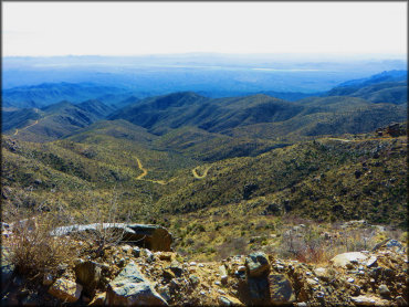
Photo Submitted 4/10/2016 (Thanks!)
Harquahala Mountain Trail Photo
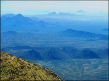
Photo Submitted 4/10/2016 (Thanks!)
Harquahala Mountain Trail Photo
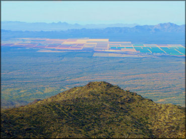
Photo Submitted 4/10/2016 (Thanks!)
Harquahala Mountain Trail Photo
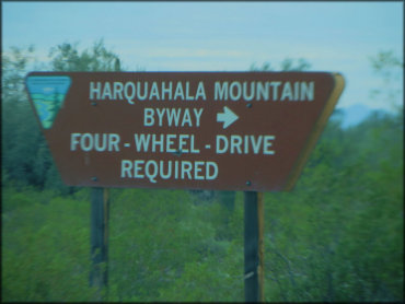
Photo Submitted 4/10/2016 (Thanks!)
RIDER COMMENTS & REVIEWS