 |
      |
| Home > California > Poleta |
Poleta OHV Area
Saturday, December 23, 2023
| Other Names | Inyo National Forest, White Mountain Ranger District, Bishop Resource Area, Redding Canyon, Poleta Canyon |
| Last Known Status | Open |
This year-round offroad area consists of hundreds of miles of trails that wind through a checkerboard of BLM and Inyo National Forest land. The trails range from smooth and fast 4x4 roads to rugged and steep single track with ridgeline views.
There are two designated staging areas that have room for primitive camping. The trails connect all the way to Owens Dry Lake and to the haunted hills and ghost town of Bodie.
REGULATIONS
| Permit Required | Yes | CA OHMVR stickers required |
| Dates Open | Year-Round | CA OHMVR red sticker vehicles permitted year round |
| Other ATV Stickers Accepted | Yes | Residents of any state not listed must purchase a Nonresident OHV Use Permit. (AR, AZ, CA, CO, CT, DE, IA, ID, IN, LA, MA, MD, ME, MI, MN, MO, MT, ND, NH, NJ, NM, NV, NY, OH, OK, OR, PA, RI, TX, UT, VT, WA, WI, WY) |
| Spark Arrestor | Yes | A spark arresting exhaust silencer or end cap is required for all vehicles. |
| Noise Limit | Yes (96 dB) | CA OHMVR noise limits apply (1985/older limit 101 dB, 1986/newer limit 96 dB) |
| Whip Flags | Not Required | |
| Maximum Vehicle Width | No Restriction | |
 Motorcycles & Dirt Bikes Motorcycles & Dirt Bikes | Permitted | CA OHMVR stickers required |
 ATVs ATVs | Permitted | CA OHMVR stickers required |
 UTV & SXS UTV & SXS | Permitted | CA OHMVR stickers required |
 SUVs & Jeeps (registered) SUVs & Jeeps (registered) | Permitted | |
| Dune Buggy & Sand Rail 4x4 (unregistered) | Permitted | CA OHMVR stickers required |
| 2 Stroke Engines | No Restriction | CA OHMVR restrictions apply |
| MX Helmet Required | Yes | helmets required by state law |
 Camping Camping | No Restriction | (camp anywhere) |
 Campfires Campfires | ||
| Night Riding | Unknown | |
| Trail Blazing | Prohibited | stay on trail |
| Rule Enforcement |
Advertisement
TYPE OF AREA
| Area | Motorized Trails |
| Land | BLM, National Forest |
FEES & PASSES
| Parking | (None) |
| Entry | (None) |
| Riding | (None) |
| Camping | (None) |
RATINGS
| Our Rating |  Good Good |
| Recommended Stay | 1-2 Days |
| Comments | (Scroll Down For Rider Reviews & Comments) |
DRIVING DIRECTIONS
| Nearest City | Bishop, CA | ||
| From: Bishop, CA
For the Lower Staging Area: 1) Take US-395 to Line Street 2) Turn east on Line Street, continue 4.4 miles 3) Staging area is on the left (east). Note: For the Upper Staging Area: 4) Continue on south on Line Street about 1 mile 5) Turn left (east) onto Redding Canyon Road, continue 1.2 miles 6) Turn left at fork, continue .5 miles to staging area. |


OFFICIAL CONTACTS
| Contact Info | BLM - Bishop Field Office 351 Pacu Lane, Suite 100 Bishop, CA 93514 (760) 872-5000 blm_ca_web_bi@blm.gov www.blm.gov |
| Contact Info | Inyo National Forest - White Mountain Ranger Station 798 North Main Street Bishop, CA 93514 (760) 873-2500 mailroom_r5_inyo@fs.fed.us www.fs.usda.gov |
Poleta Trail Photo
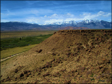
Photo Submitted 6/25/2019 (Thanks!)
Poleta Trail Photo
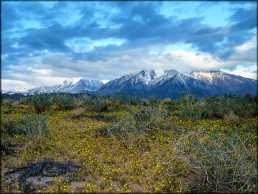
Photo Submitted 6/25/2019 (Thanks!)
ADD PHOTOS
TERRAIN
| Approx Size | 3,000 acres (5 sq mi) | |
| Miles Of Trail | 100 | |
| Climate Type | Forest | |
| Elevation | 4500 to 6500 ft. | |
| Trail Maintenance | Marked, Not Rated, Lightly Maintained | |
| Loose Dirt |  Little Little | |
| Hard Pack |  Mostly Mostly | |
| Sand | Little | |
| Mud |  None None | |
| Dust |  Some Some | |
| Rocks | Some | |
| Trees |  Few Few | |
| Steep Hills |  Many Many | |
| Water Crossings | None | |
| Small Jumps | Some | |
| Large Jumps | Few | |
| Berms | Few | |
| Sand/Gravel Pits | None | |
| Single Track | Some | |
| Roads | Mostly | |
| Intersections | Many | |
| Rider Traffic | Few | |
| Shade | None | |
| Hazards | Few | (hazards assumed marked but use caution) |
 Novice Novice | Some | |
 Amateur Amateur | Mostly | |
 Expert Expert | Little |
GPS POINTS


KEY SERVICES
 Gasoline Gasoline | 5-20 Miles (W) | Giggle Springs (760) 872-3449 |
| Diesel | 5-20 Miles (W) | Giggle Springs (760) 872-3449 |
 Water Water | 5-20 Miles (W) | Brown's Town Campground (760) 873-8522 |
 RV Hookup RV Hookup | 5-20 Miles (W) | Brown's Town Campground (760) 873-8522 |
 RV Disposal RV Disposal | 5-20 Miles (W) | Brown's Town Campground (760) 873-8522 |
| Campground | 30+ Miles (E) | Grandview Campground (760) 873-2500 |
 Conv Store Conv Store | 5-20 Miles (W) | Giggle Springs (760) 872-3449 |
RIDER COMMENTS & REVIEWS