 |
      |
| Home > California > Rubicon Trail |
Rubicon Trail
Saturday, April 13, 2024
| Other Names | Rubicon OHV Trail, Mckinney Rubicon Trail, Rubicon 4WD Trail, Mckinney Lake, Lily Lake, Miller Lake, Buck Lake, Miller Meadows, Fern Lake, Rubicon River, Long Lake, Fawn Lake, Buck Island Lake, Big Sluice, Spider Lake, Wentworth Springs Road, Little Sluice, Ellis Creek, Rubicon Springs, Eldorado National Forest, Tahoe National Forest, Lake Tahoe, Lake Tahoe Basin Management Unit, Hunters Trail |
| Last Known Status | Closed For Season |
This popular 4x4 trail is about 22 miles long and has two trailheads, one on the west side of Lake Tahoe and the other near Loon Lake. The trail offers scenic views of a mixed pine tree forest, grassy meadows, alpine lakes, rivers and streams.
Most people tackle the Rubicon from Loon Lake and head east, but the trail can be attempted in either direction. The terrain is extremely rugged and consists of huge granite boulders, loose chunk rock, several steep hill climbs and massive rock slabs to crawl over. There are some bypasses for the rough areas but no turnaround points, so if you are in a 4x4 you have to commit to the end.
Dispersed camping is permitted but there are a couple campgrounds that can accomodate those with larger trailers. Airport Flat Campground is located off Wentworth Springs Road and Icehouse Road intersection and offers 16 sites. Northshore Campground is located further north near Loon Lake which has 15 sites.
Wentworth Springs Campground is another option but only has 8 tent sites and limited parking. There are no fees charged for any of the above campgrounds but there are no services so come prepared. The campgrounds usually open for the season around Memorial Day Weekend through mid October, but exact dates vary.
This trail is open to all OHVs but Jeeps, rock crawlers or anything with four wheels will have a better time. Expect some damage and bring extra parts. Don't have a rig? Then check out one of the guided tours.
REGULATIONS
| Permit Required | Yes | CA OHMVR stickers required |
| Dates Open | June 1 - November 15 | CA OHMVR red sticker vehicles permitted year round |
| Other ATV Stickers Accepted | Yes | Residents of any state not listed must purchase a Nonresident OHV Use Permit. (AR, AZ, CA, CO, CT, DE, IA, ID, IN, LA, MA, MD, ME, MI, MN, MO, MT, ND, NH, NJ, NM, NV, NY, OH, OK, OR, PA, RI, TX, UT, VT, WA, WI, WY) |
| Spark Arrestor | Yes | A spark arresting exhaust silencer or end cap is required for all vehicles. |
| Noise Limit | Yes (96 dB) | CA OHMVR noise limits apply (1985/older limit 101 dB, 1986/newer limit 96 dB) |
| Whip Flags | Not Required | |
| Maximum Vehicle Width | No Restriction | |
 Motorcycles & Dirt Bikes Motorcycles & Dirt Bikes | Permitted | Not Recommended CA OHMVR stickers required very rocky |
 ATVs ATVs | Permitted | Not Recommended CA OHMVR stickers required |
 UTV & SXS UTV & SXS | Permitted | CA OHMVR stickers required |
 SUVs & Jeeps (registered) SUVs & Jeeps (registered) | Permitted | |
| Dune Buggy & Sand Rail 4x4 (unregistered) | Permitted | CA OHMVR stickers required |
| 2 Stroke Engines | No Restriction | CA OHMVR restrictions apply |
| MX Helmet Required | Yes | helmets required by state law |
 Camping Camping | Some Areas | (camp in developed sites only) campfire permit required, contact the ranger station for info |
 Campfires Campfires | Some Areas | (permitted in developed campsites only) |
| Night Riding | Unknown | |
| Trail Blazing | Prohibited | stay on trail |
| Rule Enforcement | Yes | Dedicated Rangers/Officers Jeep/SUV Patrol trail is regularly patrolled by Eldorado County Sheriffs |
TYPE OF AREA
| Area | Motorized Trails |
| Land | National Forest, County Land |
FEES & PASSES
| Parking | (None) |
| Entry | (None) |
| Riding | (None) |
| Camping | (None) |
RATINGS
| Our Rating |  Good Good |
| Recommended Stay | 3-4 Days even experienced drivers need a few days to complete the trail |
| Comments | (Scroll Down For Rider Reviews & Comments) |
DRIVING DIRECTIONS
| Nearest City | South Lake Tahoe, CA | ||
| From: South Lake Tahoe, CA
1) Take SR-89 North about 20 miles 2) Turn left (west) onto McKinney Rubicon Springs Road, continue .2 miles 3) Veer right onto Bellevue Ave., continue .1 miles 4) Turn right onto McKinney Road, continue .2 miles 5) Turn left onto Rubicon Trail, follow road toward staging area. For Loon Lake Staging Area: 1) Take 89 South to US 50 W 2) Take US-50 West about 30 miles 3) Turn right (north) onto Ice House Road, continue .7 miles 4) Turn right to stay on Ice House Road, continue about 30 miles toward Northshore Campground or Loon Lake Staging Area. For Airport Flat Campground: 1) Take 89 South to US 50 W 2) Take US-50 West about 30 miles 3) Turn right (north) onto Ice House Road, continue .7 miles 4) Turn right to stay on Ice House Road, continue about 23 miles 5) Turn left (north-west) onto Wentworth Springs Road, continue about 2.5 miles 6) Campground entrance is on the right. |


OFFICIAL CONTACTS
| Contact Info | Lake Tahoe Basin Management Unit 35 College Drive South Lake Tahoe, CA 96150 (530) 543-2600 sm.fs.paltbmu@usda.gov www.fs.usda.gov |
| Contact Info | Eldorado National Forest 100 Forni Road Placerville, CA 95667 (530) 622-5061 mailroom_r5_eldorado@fs.fed.us www.fs.usda.gov |
Rubicon Trail Photo
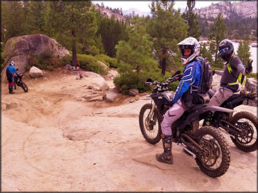
Photo Submitted 11/23/2015 (Thanks!)
ADD PHOTOS
TERRAIN
| Approx Size | 5,120 acres (8 sq mi) | |
| Miles Of Trail | 22 | |
| Climate Type | Forest | |
| Elevation | 6300 to 7100 ft. | |
| Trail Maintenance | Marked, Not Rated, Lightly Maintained | |
| Loose Dirt |  Little Little | |
| Hard Pack |  Some Some | |
| Sand |  None None | |
| Mud | Little | |
| Dust | Little | |
| Rocks |  Mostly Mostly | |
| Trees |  All All | |
| Steep Hills |  Many Many | |
| Water Crossings |  Few Few | |
| Small Jumps | None | |
| Large Jumps | None | |
| Berms | None | |
| Sand/Gravel Pits | None | |
| Single Track | None | |
| Roads | None | |
| Shade | Many | |
| Hazards | Few | (hazards assumed marked but use caution) |
 Novice Novice | Little | |
 Amateur Amateur | Some | |
 Expert Expert | Mostly |
GPS POINTS


KEY SERVICES
 Gasoline Gasoline | 5-20 Miles (S) | Icehouse Resort (530) 293-3321 |
| Diesel | 5-20 Miles (S) | Icehouse Resort (530) 293-3321 |
 Water Water | 1-5 Miles (S) | Loon Lake Campground (530) 647-5415 |
 RV Hookup RV Hookup | 1-5 Miles (S) | Loon Lake Campground (530) 647-5415 |
 RV Disposal RV Disposal | 1-5 Miles (S) | Loon Lake Campground (530) 647-5415 |
| Campground | On Site | Airport Flat Campground, Northshore Campground and Wentworth Springs Campground (530) 647-5415 |
 Conv Store Conv Store | 5-20 Miles (S) | Icehouse Resort (530) 293-3321 |
RIDER COMMENTS & REVIEWS