 |
      |
| Home > California > Elk Camp Ridge |
Elk Camp Ridge Trail
Saturday, December 23, 2023
| Other Names | Six Rivers National Forest, Patrick Creek, Old Gasquet Toll Road, Cold Spring Mountain, Holiday Road, Gasquet Mountain, Eighteen Mile Creek, Middle Fork Smith River, Trail 2E04, Smith River Canyon |
| Last Known Status | Open |
This very challenging single track trail was once an old pack train/mining road used during the late 1800's that connected the outskirts of Crescent City to the gold mines of southern Oregon. The trail is slightly over eight miles long but has some long steep climbs and descents, loose chunk rock and a few sharp switchbacks, making it geared for the more experianced rider.
There are two trailheads but the preferred acess point is the southern staging area located off Old Gasquet Toll Road. The northern trailhead is located off Patricks Creek Road but can be easy to miss. The trail can be used to access nearby High Dome Trail, and when combined with the surrounding forest service roads, this area can offer provide several long loop options.
Camping is permitted at the lower trailhead but there are plenty of campsites off Hwy 199 and Patricks Creek Road. Overall, this area is best explored on a street legal dual sport motorcycle. The trail is open year-round but may be inaccessible during the winter months. Call before you haul.
REGULATIONS
| Permit Required | Yes | CA OHMVR stickers required |
| Dates Open | Year-Round | CA OHMVR red sticker vehicles permitted year round |
| Other ATV Stickers Accepted | Yes | Residents of any state not listed must purchase a Nonresident OHV Use Permit. (AR, AZ, CA, CO, CT, DE, IA, ID, IN, LA, MA, MD, ME, MI, MN, MO, MT, ND, NH, NJ, NM, NV, NY, OH, OK, OR, PA, RI, TX, UT, VT, WA, WI, WY) |
| Spark Arrestor | Yes | A spark arresting exhaust silencer or end cap is required for all vehicles. |
| Noise Limit | Yes (96 dB) | CA OHMVR noise limits apply (1985/older limit 101 dB, 1986/newer limit 96 dB) |
| Whip Flags | Not Required | |
| Maximum Vehicle Width | Yes (40 inches) | narrow terrain |
 Motorcycles & Dirt Bikes Motorcycles & Dirt Bikes | Permitted | CA OHMVR stickers required |
 ATVs ATVs | Prohibited | CA OHMVR stickers required |
 UTV & SXS UTV & SXS | Prohibited | CA OHMVR stickers required |
 SUVs & Jeeps (registered) SUVs & Jeeps (registered) | Prohibited | |
| Dune Buggy & Sand Rail 4x4 (unregistered) | Prohibited | CA OHMVR stickers required |
| 2 Stroke Engines | No Restriction | CA OHMVR restrictions apply |
| MX Helmet Required | Yes | helmets required by state law |
 Camping Camping | Some Areas | (camp in developed sites only) |
 Campfires Campfires | Some Areas | (permitted in developed campsites only) |
| Night Riding | Unknown | Not Recommended |
| Trail Blazing | Prohibited | stay on trail |
| Rule Enforcement |
TYPE OF AREA
| Area | Motorized Trails |
| Land | National Forest |
FEES & PASSES
| Parking | (None) |
| Entry | (None) |
| Riding | (None) |
| Camping | (None) |
RATINGS
| Our Rating |  Good Good |
| Recommended Stay | Full Day |
| Comments | (Scroll Down For Rider Reviews & Comments) |
DRIVING DIRECTIONS
| Nearest City | Gasquet, CA | ||
| Address | Old Gasquet Toll Road, Gasquet, CA 95543 | ||
| From: Crescent City, CA
1) Take US-199 East about 20 miles 2) Turn left (north) onto Middle Fork Gasquet Road, continue .3 miles 3) Veer right onto Gasquet Road, continue .5 miles 4) Veer right (south) onto County Road 314/Old Gasquet Toll Road, continue 2.4 miles 5) Staging area and trailhead is on the left (north). |


OFFICIAL CONTACTS
| Contact Info | Six Rivers National Forest - Smith River NRA Highway 199 P.O. Box 228 Gasquet, CA 95543 (707) 457-3131 mailroom_r5_six_rivers@usda.gov www.fs.usda.gov |
Elk Camp Ridge Trail Photo
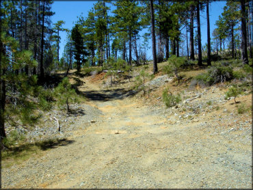
This is the northern trailhead located off Old Gasquet Toll Road. If you go pass this point 1.5 miles you will reach the High Dome Trailhead.
ADD PHOTOS
TERRAIN
| Approx Size | 9,600 acres (15 sq mi) | |
| Miles Of Trail | 8 | |
| Climate Type | Forest | |
| Elevation | 2100 to 3700 ft. | |
| Trail Maintenance | Marked, Not Rated, Lightly Maintained | |
| Loose Dirt |  Little Little | |
| Hard Pack |  Mostly Mostly | |
| Sand |  None None | |
| Mud | Little | |
| Dust | Little | |
| Rocks |  Some Some | |
| Trees |  All All | |
| Steep Hills | Some | |
| Water Crossings | None | |
| Small Jumps | None | |
| Large Jumps | None | |
| Sand/Gravel Pits | None | |
| Single Track | All | |
| Roads | Some | |
| Shade | Some | |
| Hazards |  Few Few | (hazards assumed marked but use caution) |
 Novice Novice | Little | |
 Amateur Amateur | Mostly | |
 Expert Expert | Some |


KEY SERVICES
 Gasoline Gasoline | 5-20 Miles (SW) | Chevron (707) 458-3114 |
| Diesel | 5-20 Miles (SW) | Chevron (707) 458-3114 |
 Water Water | 1-5 Miles (SE) | Panther Flat Campground (707) 442-1721 |
 RV Hookup RV Hookup | 5-20 Miles (SW) | Hiouchi Hamlet RV Resort (707) 458-3321 |
 RV Disposal RV Disposal | 5-20 Miles (SW) | Hiouchi Hamlet RV Resort (707) 458-3321 |
| Campground | 1-5 Miles (SE) | Panther Flat Campground (707) 442-1721 |
 Conv Store Conv Store | 1-5 Miles (SW) | Gasquet Market (707) 457-3312 |
RIDER COMMENTS & REVIEWS