 |
      |
| Home > Colorado > Resolution Mountain |
Resolution Mountain
Saturday, December 23, 2023
| Other Names | White River National Forest, Holy Cross Ranger District, Wearyman Road, Resolution Road, Red Cliff, Camp Hale Memorial Campground, Ptarmigan Pass, Hornsilver Mountain, Vail Pass Recreation Area, McCallister Gulch |
| Last Known Status | Open |
This long but scenic 4x4 route has some steep but gradual climbs but offers some great mountain and alpine meadow views. The trail system mainly consists of two forest service roads - Wearyman and Resolution Road. Wearyman is the northern access and eventually connects to Ptarmigan Pass which ties into Resolution Road, which heads in a southwestern direction.
Most of the trail is rugged and narrow but is wide enough for Jeeps and side by sides. Camping with nearby trail access can be found at Camp Hale Memorial Campground, which has 21 shady sites overlooking the Eagle River.
Nearby Colorado Backcountry Rentals offers unguided ATV rentals (rental rates include gas and helmets). During the winter months snowmobile and showshoe rentals are offered.
REGULATIONS
| Permit Required | Yes | Colorado OHV Sticker |
| Dates Open | June 1 - November 15 | |
| Other ATV Stickers Accepted | No | Colorado Non-Resident OHV permit required. |
| Spark Arrestor | Yes | A spark arresting exhaust silencer or end cap is required for all vehicles. |
| Noise Limit | Yes (96 dB) | (1998/older limit 99 dB, 1998/newer limit 96 dB) |
| Whip Flags | Not Required | |
| Maximum Vehicle Width | No Restriction | |
 Motorcycles & Dirt Bikes Motorcycles & Dirt Bikes | Permitted | |
 ATVs ATVs | Permitted | |
 UTV & SXS UTV & SXS | Permitted | |
 4x4 & Jeeps (registered) 4x4 & Jeeps (registered) | Permitted | |
| Dune Buggy & Sand Rail 4x4 (unregistered) | Permitted | |
| 2 Stroke Engines | No Restriction | |
| MX Helmet Required | Yes | |
 Camping Camping | Some Areas | (camp in developed sites only) |
 Campfires Campfires | Some Areas | (permitted in developed campsites only) |
| Night Riding | Unknown | |
| Trail Blazing | Prohibited | stay on trail |
| Rule Enforcement |
TYPE OF AREA
| Area | Motorized Trails |
| Land | National Forest |
FEES & PASSES
| Parking | (None) |
| Entry | (None) |
| Riding | (None) |
| Camping | Yes Tent: $19.00 RV: $19.00 Addtl. Vehicle: $0.00 Camp Hale Memorial Campground Fee |
RATINGS
| Our Rating |  Good Good |
| Recommended Stay | Full Day |
| Comments | (Scroll Down For Rider Reviews & Comments) |
DRIVING DIRECTIONS
| Nearest City | Red Cliff, CO | ||
| From: Denver, CO
1) Take I-70 west to exit 171 2) Merge onto US 6/Hwy 24 south, continue about 16 miles 3) Turn left (east) onto 10th Mountan Div Memorial Hwy, continue about 1 block 4) Turn left (east) onto Camp Hale Spur 1B, continue .2 miles 5) Turn right (south) onto FS Road 716, continue about 1 mile toward Camp Hale Memorial Campground. |


OFFICIAL CONTACTS
| Contact Info | White River National Forest - Holy Cross Ranger District 24747 US Highway 24 Minturn, CO 81645 (970) 827-5715 mailroom_r2_white_river@fs.fed.us www.fs.usda.gov |
| Contact Info | Colorado Backcountry Rentals 164 Railroad Avenue Minturn, CO 81657 (970) 406-1397 coloradobackcountryrentals@yahoo.com coloradobackcountryrentals.com |
Resolution Mountain Trail Photo
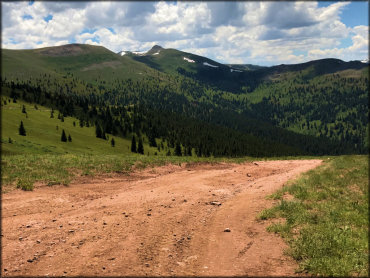
Photo Submitted 8/11/2017 (Thanks!)
Resolution Mountain Trail Photo
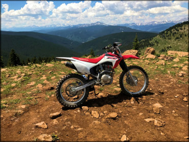
Photo Submitted 8/11/2017 (Thanks!)
ADD PHOTOS
TERRAIN
| Miles Of Trail | 10 | |
| Climate Type | Forest | |
| Elevation | 9200 to 12000 ft. | |
| Trail Maintenance | Marked, Not Rated, Lightly Maintained | |
| Loose Dirt |  None None | |
| Hard Pack |  Mostly Mostly | |
| Sand | None | |
| Mud |  Little Little | |
| Dust | Little | |
| Rocks |  Some Some | |
| Trees |  All All | |
| Steep Hills | Some | |
| Water Crossings |  Few Few | |
| Small Jumps | None | |
| Large Jumps | None | |
| Berms | None | |
| Sand/Gravel Pits | None | |
| Single Track | None | |
| Roads | Mostly | |
| Shade |  Many Many | |
| Hazards | Few | (hazards assumed marked but use caution) |
 Novice Novice | Some | |
 Amateur Amateur | Mostly | |
 Expert Expert | Little |

KEY SERVICES
 Gasoline Gasoline | 5-20 Miles (S) | Shell (719) 486-1200 |
| Diesel | 5-20 Miles (S) | Shell (719) 486-1200 |
 Water Water | 5-20 Miles (SW) | Sugar Loafin Campground (719) 486-1031 |
 RV Hookup RV Hookup | 5-20 Miles (SW) | Sugar Loafin Campground (719) 486-1031 |
 RV Disposal RV Disposal | 5-20 Miles (SW) | Sugar Loafin Campground (719) 486-1031 |
| Campground | On Site | Camp Hale Memorial Campground (970) 827-5715 |
 Conv Store Conv Store | 5-20 Miles (S) | Shell (719) 486-1200 |
RIDER COMMENTS & REVIEWS