 |
      |
| Home > Colorado > Straight Creek Trail |
Straight Creek Trail
Saturday, December 23, 2023
| Other Names | Tenderfoot Mountain, Eisenhower Tunnel, Blue River, White River National Forest, Dillon Ranger District |
| Last Known Status | Closed For Season |
This old logging road follows I-70 and ends near the Eisenhower Tunnel. The trail is roughly six miles long each way and is rated as moderately challenging (depending on the weather) due to moderate elevation changes, loose chunk rock and several challenging creek crossings.
The main staging area has minimal parking and is gated. As of this writing there is no fee charged to ride or park, but motorcycles must display a current Colorado OHV Sticker.
The trail is seasonal and usually opens to motorized use around late May through the end of November. Exact dates vary so call before you haul.
REGULATIONS
| Permit Required | Yes | Colorado OHV Sticker |
| Dates Open | May 21 - November 22 | |
| Other ATV Stickers Accepted | No | Colorado Non-Resident OHV permit required. |
| Spark Arrestor | Yes | A spark arresting exhaust silencer or end cap is required for all vehicles. |
| Noise Limit | Yes (96 dB) | (1998/older limit 99 dB, 1998/newer limit 96 dB) |
| Whip Flags | Not Required | |
| Maximum Vehicle Width | Yes (50 inches) | has entrance gate and narrow terrain |
 Motorcycles & Dirt Bikes Motorcycles & Dirt Bikes | Permitted | |
 ATVs ATVs | Permitted | (maximum width 50 inches) |
 UTV & SXS UTV & SXS | Permitted | (maximum width 50 inches) |
 4x4 & Jeeps (registered) 4x4 & Jeeps (registered) | Prohibited | |
| Dune Buggy & Sand Rail 4x4 (unregistered) | Prohibited | |
| 2 Stroke Engines | No Restriction | |
 Camping Camping | ||
 Campfires Campfires | ||
| Night Riding | Unknown | |
| Trail Blazing | Prohibited | stay on trail |
| Rule Enforcement |
TYPE OF AREA
| Area | Motorized Trails |
| Land | National Forest |
FEES & PASSES
| Parking | (None) |
| Entry | (None) |
| Riding | (None) |
| Camping | (None) |
RATINGS
| Our Rating |  Good Good |
| Recommended Stay | Full Day |
| Comments | (Scroll Down For Rider Reviews & Comments) |
DRIVING DIRECTIONS
| Nearest City | Dillon, CO | ||
| From: Denver, CO
1) Take I-70 west to Exit 205 2) Turn left (south) off the exit ramp onto Hwy 6, continue about 1 mile 3) Turn left (north) onto Evergreen Road then take an immediate right (east) onto County Road 51, continue about 2 miles toward staging area. |


OFFICIAL CONTACTS
| Contact Info | White River National Forest - Dillon Ranger District 680 Blue River Pkwy Silverthorne, CO 80498 (970) 468-5400 mailroom_r2_white_river@fs.fed.us www.fs.usda.gov |
Straight Creek Trail Photo
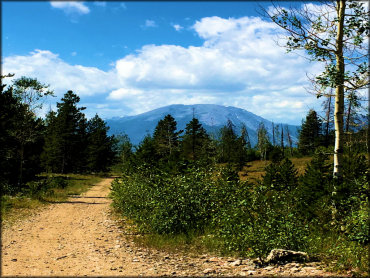
Photo Submitted 9/11/2019 (Thanks!)
Straight Creek Trail Photo
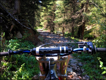
Photo Submitted 9/11/2019 (Thanks!)
Straight Creek Trail Photo
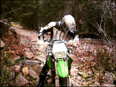
Photo Submitted 4/19/2016 (Thanks!)
ADD PHOTOS
TERRAIN
| Miles Of Trail | 12 | |
| Climate Type | Forest | |
| Elevation | 9314 to 12777 ft. | |
| Trail Maintenance | Marked, Not Rated, Lightly Maintained | |
| Loose Dirt |  Little Little | |
| Hard Pack |  Mostly Mostly | |
| Sand |  None None | |
| Mud | Little | |
| Dust | Little | |
| Rocks | Mostly | |
| Trees |  All All | |
| Steep Hills | None | |
| Water Crossings |  Many Many | |
| Small Jumps | None | |
| Large Jumps | None | |
| Berms | None | |
| Sand/Gravel Pits | None | |
| Single Track | None | |
| Roads |  Few Few | |
| Shade | Many | |
| Hazards | Few | (hazards assumed marked but use caution) |
 Novice Novice | Little | |
 Amateur Amateur | Mostly | |
 Expert Expert |  Some Some |


KEY SERVICES
 Gasoline Gasoline | 1-5 Miles (SW) | City Market Gas Station (970) 468-2363 |
| Diesel | 1-5 Miles (SW) | City Market Gas Station (970) 468-2363 |
 Water Water | 1-5 Miles (SW) | Heaton Bay Campground (970) 945-2521 |
 RV Hookup RV Hookup | 1-5 Miles (SW) | Heaton Bay Campground (970) 945-2521 |
 RV Disposal RV Disposal | 5-20 Miles (S) | Upper Blue Sanitation District (970) 453-6442 |
| Campground | 1-5 Miles (SW) | Heaton Bay Campground (970) 945-2521 |
 Conv Store Conv Store | 1-5 Miles (SW) | City Market Gas Station (970) 468-2363 |
RIDER COMMENTS & REVIEWS