 |
      |
| Home > Kentucky > MOP |
Mountain Parkway Off-Road Park
Saturday, December 23, 2023
| Other Names | Mop Off Road, Hardwick Creek, Rose Lane |
| Last Known Status | Closed |
This offroad park at one time offered miles of trails that ranged from easy to challenging and a motocross track but is now closed. This listing will remain up for historical purposes.
REGULATIONS
| Permit Required | ||
| Dates Open | Closed | |
| Spark Arrestor | Recommended | A spark arresting exhaust silencer or end cap is recommended. |
| Noise Limit | ||
| Whip Flags | Not Required | |
| Maximum Vehicle Width | ||
 Motorcycles & Dirt Bikes Motorcycles & Dirt Bikes | Permitted | |
 Four Wheelers Four Wheelers | Permitted | |
 UTV & SXS UTV & SXS | Prohibited | |
 SUVs & Jeeps (registered) SUVs & Jeeps (registered) | Prohibited | |
| Dune Buggy & Sand Rail 4x4 (unregistered) | Prohibited | |
| 2 Stroke Engines | No Restriction | |
 Camping Camping | Some Areas | (camp in developed sites only) |
 Campfires Campfires | ||
| Night Riding | Unknown | |
| Trail Blazing | Prohibited | stay on the trail |
| Rule Enforcement |
Advertisement
TYPE OF AREA
| Area | Motorized Trails, MX Track |
| Land | Privately Owned / Commercial |
FEES & PASSES
| Parking | (Unknown) |
| Entry | (Unknown) |
| Riding | Yes ($15.00 per rider) $25.00 per rider for 2 days |
| Camping | (None) |
RATINGS
| Our Rating |  |
| Recommended Stay | Full Day |
| Comments | (Scroll Down For Rider Reviews & Comments) |
DRIVING DIRECTIONS
| Nearest City | Clay City, KY | ||
| Address | 201 Lake Drive, Clay City, KY 40312 | ||
| From: Lexington, KY
1) Take I-64 east to exit 98, about 20 miles (exit 98 merges onto Bart T. Combs Mountain Parkway) 2) Continue about 16 miles on Bart T. Combs Mountain Parkway to exit 16 3) Turn left off the exit ramp on SR-15/Winchester Road, continue about 2 miles 4) Turn right on SR-1057, continue 3.7 miles 5) Turn left on Rose Lane, proceed toward the park entrance. |


OFFICIAL CONTACTS
MOP OHV Area Photo
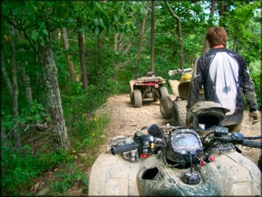
Photo Submitted 3/26/2014 (Thanks!)
ADD PHOTOS
TERRAIN
| Approx Size | 2,000 acres (3 sq mi) | |
| Climate Type | Forest | |
| Elevation | 650 to 1200 ft. | |
| Trail Maintenance | Unknown | |
| Loose Dirt |  Some Some | |
| Hard Pack |  Little Little | |
| Sand | Little | |
| Mud |  Mostly Mostly | |
| Dust | Little | |
| Rocks | Little | |
| Trees |  Many Many | |
| Steep Hills |  Few Few | |
| Water Crossings | Few | |
| Small Jumps |  None None | |
| Large Jumps | None | |
| Hazards | Few | (hazards assumed marked but use caution) |
 Novice Novice | Some | |
 Amateur Amateur | Mostly | |
 Expert Expert | Some |
GPS POINTS


KEY SERVICES
 Gasoline Gasoline | 1-5 Miles (N) | McKinney's Food Mart (606) 663-4332 |
| Diesel | 1-5 Miles (N) | McKinney's Food Mart (606) 663-4332 |
 Water Water | 20-30 Miles (SE) | Natural Bridge State Resort Middlefork Campground (606) 663-2214 |
 RV Hookup RV Hookup | 20-30 Miles (SE) | Natural Bridge State Resort Middlefork Campground (606) 663-2214 |
 RV Disposal RV Disposal | 20-30 Miles (SE) | Natural Bridge State Resort Middlefork Campground (606) 663-2214 |
| Campground | On Site | |
 Conv Store Conv Store | 1-5 Miles (N) | McKinney's Food Mart (606) 663-4332 |
RIDER COMMENTS & REVIEWS