 |
      |
| Home > Louisiana > Zman's MX |
Zmans MX
Saturday, December 23, 2023
| Other Names | Area 751 Adventure Sports, Hwy 70 MX |
| Last Known Status | Open (open during select weekends) |
This motocross park has reopened to the public after a brief period of closure. The property offers a main track that is groomed and watered and a separate peewee track for beginners. Amenities include shaded parking area and a concession stand. As of this writing the track is only open during select weekends so call first before heading out.
REGULATIONS
| Permit Required | No | |
| Dates Open | open during select weekends | |
| Spark Arrestor | No | A spark arresting exhaust silencer or end cap is not required but is always recommended. |
| Noise Limit | No | |
| Whip Flags | ||
| Maximum Vehicle Width | ||
 Motorcycles & Dirt Bikes Motorcycles & Dirt Bikes | Permitted | |
 Four Wheelers Four Wheelers | Prohibited | |
 UTV & SXS UTV & SXS | Prohibited | |
 SUVs & Jeeps (registered) SUVs & Jeeps (registered) | Prohibited | |
| Dune Buggy & Sand Rail 4x4 (unregistered) | Prohibited | |
| 2 Stroke Engines | No Restriction | |
| MX Helmet Required | Yes | |
 Camping Camping | Prohibited | |
 Campfires Campfires | Prohibited | |
| Night Riding | No | |
| Alcohol | Prohibited | |
| Rule Enforcement |
Advertisement
TYPE OF AREA
| Area | MX Track |
| Land | Privately Owned / Commercial |
MX TRACK 
| Features | Public |
| Max Engine Size | No Maximum |
| Min Engine Size | No Minimum |
MX TRACK
| Features | Public, Watered, Groomed |
| Max Engine Size | 65 cc Max |
| Min Engine Size | 50 cc Min |
| Comment | PeeWee Track |
FEES & PASSES
| Parking | (None) |
| Entry | (None) |
| Riding | Yes ($40.00 per rider) kids 7 and under - $30/rider |
| Camping | (None) |
RATINGS
| Our Rating |  Good Good |
| Recommended Stay | Full Day |
| Comments | (Scroll Down For Rider Reviews & Comments) |
DRIVING DIRECTIONS
| Nearest City | Paincourtville, LA | ||
| Address | 6266 LA 70, Paincourtville, LA 70391 | ||
| From: Baton Rouge, LA
1) Take I-10 east to exit 182 2) Turn right off the exit ramp onto SR-22, continue .3 miles 3) Turn left (south) onto SR-70, continue 18 miles 4) Track entrance is on the left. |


OFFICIAL CONTACTS
| Contact Info | Barry Leblanc (Owner) Zman's MX 6266 LA 70 Paincourtville, LA 70391 (985) 498-1693 barryleblanctrucking@gmail.com |
Zman's MX Track Photo
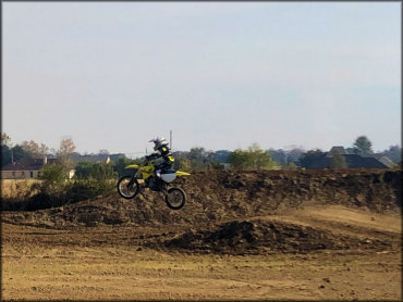
Photo Submitted 12/26/2019 (Thanks!)
Zman's MX Track Photo
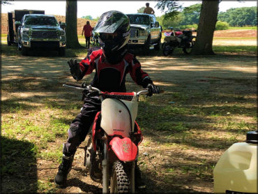
Photo Submitted 6/27/2019 (Thanks!)
ADD PHOTOS
TERRAIN
| Approx Size | 21 acres | |
| Climate Type | Urban/man-made | |
| Elevation | 15 to 30 ft. | |
| Loose Dirt |  All All | |
| Hard Pack |  None None | |
| Sand | None | |
| Mud | None | |
| Dust |  Little Little | |
| Rocks | None | |
| Trees |  Some Some | |
| Steep Hills | None | |
| Water Crossings | None | |
| Small Jumps |  Many Many | |
| Large Jumps | Some | |
| Berms | All | |
| Sand/Gravel Pits | None | |
| Single Track | None | |
| Roads | None | |
| Shade |  Few Few | |
| Hazards | Few | (hazards assumed marked but use caution) |
 Novice Novice | Some | |
 Amateur Amateur |  Mostly Mostly | |
 Expert Expert | Little |


KEY SERVICES
 Gasoline Gasoline | 1-5 Miles (SE) | Plattenville Self-Serv (985) 369-2559 |
| Diesel | 5-20 Miles (NE) | Shell (225) 473-0903 |
 Water Water | Paincourtville, LA | |
 RV Hookup RV Hookup | 30+ Miles (NE) | Yogi Bear's Jellystone Park (985) 542-1507 |
 RV Disposal RV Disposal | 30+ Miles (NE) | Yogi Bear's Jellystone Park (985) 542-1507 |
| Campground | 30+ Miles (SW) | Lonely Oaks Campground (985) 395-6765 |
 Conv Store Conv Store | 1-5 Miles (SE) | Plattenville Self-Serv (985) 369-2559 |
RIDER COMMENTS & REVIEWS