 |
      |
| Home > Nevada > Keystone Canyon |
Keystone Canyon
Saturday, December 23, 2023
| Other Names | Highland Ditch, Bull Ranch Creek, Toiyabe National Forest, Rancho San Rafael Regional Park, Peavine Peak, Humboldt Toiyabe National Forest |
| Last Known Status | Open |
Still legal, last time we checked, but fading fast. There are two trailheads here. The east (first one you encounter) is for non-motorized use only. The west trailhead is for off highway vehicles. The area is being developed fast, but the best trails are actually quite a distance in the National Forest. Keep heading west and the trails eventually tie into Bull Ranch Creek.
REGULATIONS
| Permit Required | Yes | NVOHV sticker required |
| Dates Open | Year-Round | |
| Other ATV Stickers Accepted | Yes | Nevada registration is not required if the vehicle is already registered in another state and will be located in Nevada for no more than 15 days. |
| Spark Arrestor | Yes | A spark arresting exhaust silencer or end cap is required for all vehicles. |
| Noise Limit | Yes (96 dB) | |
| Whip Flags | Not Required | |
| Maximum Vehicle Width | No Restriction | |
 Motorcycles & Dirt Bikes Motorcycles & Dirt Bikes | Permitted | |
 ATVs ATVs | Permitted | |
 UTV & SXS UTV & SXS | Permitted | |
 SUVs & Jeeps (registered) SUVs & Jeeps (registered) | Permitted | |
| Dune Buggy & Sand Rail 4x4 (unregistered) | Permitted | |
| 2 Stroke Engines | No Restriction | |
 Camping Camping | No Restriction | Not Recommended (camp anywhere) |
 Campfires Campfires | Prohibited | |
| Night Riding | Yes | Not Recommended |
| Trail Blazing | Prohibited | stay on designated trails |
| Alcohol | No Restriction | |
| Rule Enforcement | Few/Periodic |
TERRAIN
| Approx Size | 3,200 acres (5 sq mi) | |
| Miles Of Trail | 3 | |
| Climate Type | Desert | |
| Elevation | 4900 to 5800 ft. | |
| Trail Maintenance | Marked, Not Rated, Lightly Maintained | |
| Loose Dirt |  Little Little | |
| Hard Pack |  Mostly Mostly | |
| Sand |  None None | |
| Mud | Little | |
| Dust | Mostly | |
| Rocks |  Some Some | |
| Trees | Some | |
| Steep Hills |  Few Few | |
| Water Crossings | Few | |
| Small Jumps | Few | |
| Large Jumps | None | |
| Berms | Few | |
| Sand/Gravel Pits | None | |
| Single Track | Few | |
| Roads | Some | |
| Intersections | Few | |
| Rider Traffic | Few | |
| Shade | None | |
| Ranges/Gunfire | Few | |
| Hazards | Few | (hazards not marked) |
 Novice Novice | Some | |
 Amateur Amateur | Mostly | |
 Expert Expert | Little | |
| Comment | The main area in the vicinity of the staging lot is mosty rocky fire roads with some dusty ATV side trails. If you continue far enough west, however, you will reach the Peavine / Bull Ranch Creek area, with more trees and various woods single track trails. | |
TYPE OF AREA
| Area | Motorized Trails |
| Land | National Forest |
GPS POINTS


KEY SERVICES
 Gasoline Gasoline | 1-5 Miles (SE) | Wolf Fastop Food Mart (775) 327-4110 |
| Diesel | 1-5 Miles (SE) | Wolf Fastop Food Mart (775) 327-4110 |
 Water Water | 1-5 Miles (SE) | Keystone RV Park (775) 324-5000 or (800) 686-8559 |
 RV Hookup RV Hookup | 1-5 Miles (SE) | Keystone RV Park (775) 324-5000 or (800) 686-8559 |
 RV Disposal RV Disposal | 1-5 Miles (SE) | Keystone RV Park (775) 324-5000 or (800) 686-8559 |
| Campground | 5-20 Miles (W) | Reno KOA at Boomtown (775) 345-2444 |
 Conv Store Conv Store | 1-5 Miles (SE) | Wolf Fastop Food Mart (775) 327-4110 |
FEES & PASSES
| Parking | (None) |
| Entry | (None) |
| Riding | (None) |
| Camping | (None) |
RATINGS
| Pros | free, alternate access point to peavine mountain and bull ranch creek |
| Cons | only one staging area, other parking areas are for non-motorized use only, nothing too interesting in the immediate area |
| Our Rating |  Fair Fair |
| Recommended Stay | Half Day |
| Comments | (Scroll Down For Rider Reviews & Comments) |
DRIVING DIRECTIONS
| Nearest City | Reno, NV | ||
| From: Reno, NV
1) Take I-80 to Exit 10 2) Turn north off the exit ramp onto N. McCarran Blvd., continue 2.2 miles 3) Turn left on Victory Lane, continue about .25 miles 4) Turn left at the T-intersection onto Leadership Pkwy., continue about 1 mile 5) Turn right at the roundabout (you will see a sign to keep right) 6) Halfway into the roundabout turn right again (you will see a brown forest service sign) 7) Turn right at the brown forest service sign, continue to the West Keystone Trailhead. |


OFFICIAL CONTACTS
| Contact Info | Humboldt - Toiyabe National Forest - Supervisor's Office 1200 Franklin Way Sparks, NV 89431 (775) 331-6444 mailroom_r4_humboldt_toiyabe@fs.fed.us www.fs.usda.gov |
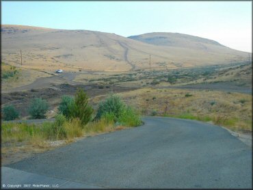
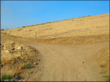
Keystone Canyon Trail Photo
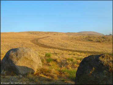
Fortunately most of the riding is way up over this hill a few miles in. That will most likely stay.
Keystone Canyon Trail Photo
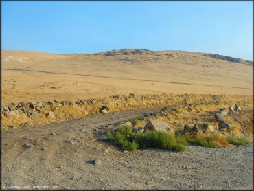
The trail gets off to a simple start, but there area a lot of great trails once you get over the first few hills.
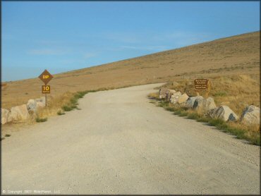
Keystone Canyon Trail Photo
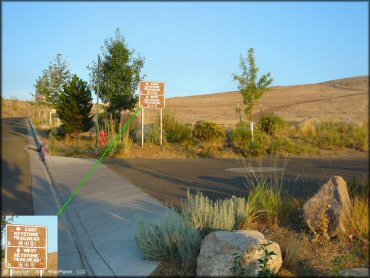
Keep going straight and be sure you reach the WEST Keystone Trailhead. (Note the MC symbol on bottom of the sign.)
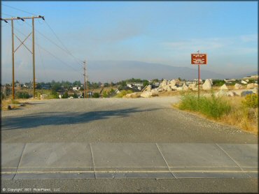
Keystone Canyon Trail Photo
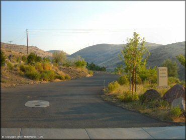
This is the entrance to the non-motorized area.
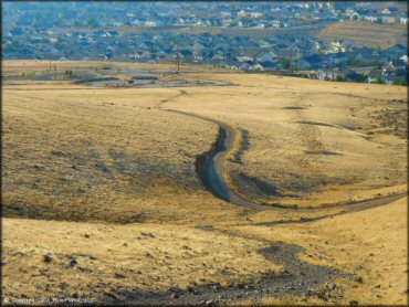
Keystone Canyon Trail Photo
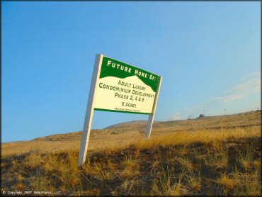
Yikes! That's not good. Used to be ours, soon to be theirs.
Keystone Canyon Trail Photo
Keystone Canyon Trail Photo
This is the entrance to the WEST trailhead, which is for motorized use.
Keystone Canyon Trail Photo
Ride up this road to reach the trails.
Keystone Canyon Trail Photo
Keystone Canyon Trail Photo
A look back at the staging area - hmm how long is that gonna last?
Keystone Canyon Trail Photo
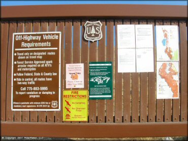
When the new residents try to tell you that you can't ride here, point to this sign. It's in the center of at the staging area.
Keystone Canyon Trail Photo
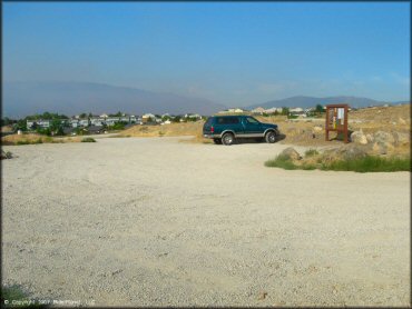
The staging area is small with no amenities other than the kiosk.
RIDER COMMENTS & REVIEWS