 |
      |
| Home > New Mexico > Cedro Peak |
Cedro Peak
Sunday, February 25, 2024
| Other Names | Sandia Ranger District, East Mountains, Cibola National Forest, Chamisoso Canyon, Cedro Canyon, Primera Agua Canyon, Tunnel Canyon, Otero Canyon, Sandia Mountains, Manzanita Mountains |
| Last Known Status | Open |
This part of the Cibola National Forest offers a large multiple use trail system that ranges from hard packed and rocky to smooth single track. The trails wind through a mixed pinyon pine, juniper and ponderosa forest.
There are currently eight trailheads and roughly 80 miles of trails that form long loops. This is a good place to go for a quick day ride or for the weekend.
Primitive camping is permitted at select routes (see map) however Oak Flat and Cedro Group Campgrounds can be reserved online.
REGULATIONS
| Permit Required | Yes | NM OHV Permit |
| Dates Open | Year-Round | |
| Other ATV Stickers Accepted | Yes | Residents of any state without an OHV registration program must purchase a Nonresident OHV Use Permit. (AK, AL, FL, GA, HI, IL, KS, KY, MS, NC, NE, OK, SC, SD, TN, VA, WV) |
| Spark Arrestor | Yes | A spark arresting exhaust silencer or end cap is required for all vehicles. |
| Noise Limit | Yes (96 dB) | |
| Whip Flags | Not Required | |
| Maximum Vehicle Width | ||
 Motorcycles & Dirt Bikes Motorcycles & Dirt Bikes | Permitted | |
 ATVs ATVs | Some Areas | Not Recommended permitted on designated forest service roads |
 UTV & SXS UTV & SXS | Some Areas | Not Recommended permitted on designated forest service roads |
 SUVs & Jeeps (registered) SUVs & Jeeps (registered) | Some Areas | Not Recommended permitted on designated forest service roads |
| Dune Buggy & Sand Rail 4x4 (unregistered) | Some Areas | permitted on designated forest service roads |
| 2 Stroke Engines | No Restriction | |
| MX Helmet Required | Youth Only | required for persons under 18 by state law (RiderPlanet strongly recommends helmets for all riders.) |
 Camping Camping | Some Areas | (camp in developed sites only) |
 Campfires Campfires | Some Areas | (permitted in developed campsites only) |
| Night Riding | Unknown | |
| Trail Blazing | Prohibited | stay on trail |
| Rule Enforcement |
TYPE OF AREA
| Area | Motorized Trails |
| Land | National Forest |
FEES & PASSES
| Parking | Yes ($5.00) |
| Entry | (None) |
| Riding | (None) |
| Camping | (None) |
RATINGS
| Our Rating |  Good Good |
| Recommended Stay | 1-2 Days |
| Comments | (Scroll Down For Rider Reviews & Comments) |
DRIVING DIRECTIONS
| Nearest City | Tijeras, NM | ||
| Address | Chamisoso Canyon Road, Tijeras, NM 87059 | ||
| From: Albuquerque, NM
1) Take I-40 East to Exit 175 2) Turn right (south) on SR-337, continue 1.4 miles 3) Turn left (east) on Chamisoso Canyon Road, continue .25 miles 4) Staging area is on the right (south). |


OFFICIAL CONTACTS
| Contact Info | Cibola National Forest - Sandia Ranger District 11776 Highway 337 Tijeras, NM 87059 (505) 281-3304 mailroom_r3_cibola@fs.fed.us www.fs.usda.gov |
| Contact Info | New Mexico Game And Fish 1 Wildlife Way Santa Fe, NM 87507 (888) 248-6866 (505) 476-8000 ispa@state.nm.us www.wildlife.state.nm.us |
| Comment | OHV Permit Info |
Cedro Peak Trail Photo
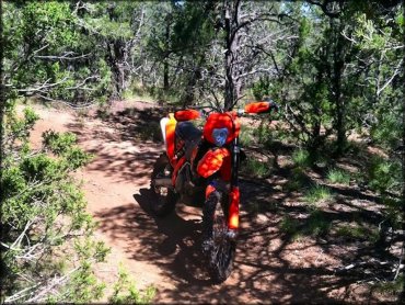
Photo Submitted 9/19/2014 (Thanks!)
Cedro Peak Trail Photo
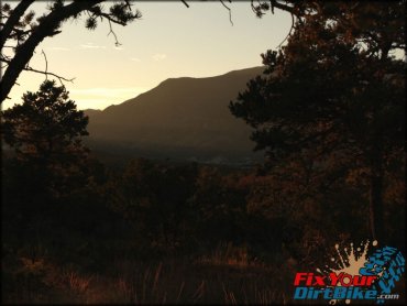
Photo Submitted 1/4/2015 (Thanks!)
Cedro Peak Trail Photo
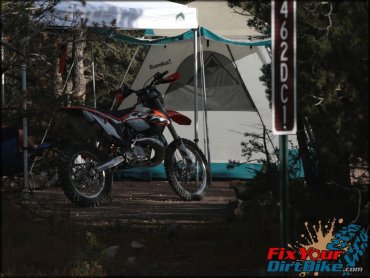
Photo Submitted 1/4/2015 (Thanks!)
ADD PHOTOS
TERRAIN
| Approx Size | 19,200 acres (30 sq mi) | |
| Miles Of Trail | 80 | |
| Climate Type | Forest | |
| Elevation | 6400 to 7800 ft. | |
| Trail Maintenance | Marked, Not Rated, Lightly Maintained | |
| Loose Dirt |  Little Little | |
| Hard Pack |  Mostly Mostly | |
| Sand |  None None | |
| Mud | Little | |
| Dust | Little | |
| Rocks |  Some Some | |
| Trees | Some | |
| Steep Hills | Some | |
| Small Jumps | None | |
| Large Jumps | None | |
| Berms |  Few Few | |
| Sand/Gravel Pits | None | |
| Single Track |  Many Many | |
| Roads | Few | |
| Intersections | Some | |
| Rider Traffic | Few | |
| Shade | Some | |
| Hazards | Few | (hazards assumed marked but use caution) |
 Novice Novice | Some | |
 Amateur Amateur | Mostly | |
 Expert Expert | Little |
GPS POINTS

KEY SERVICES
 Gasoline Gasoline | 1-5 Miles (N) | Cedar Crest Chevron Redi-Mart (505) 286-5500 |
| Diesel | 1-5 Miles (N) | Cedar Crest Chevron Redi-Mart (505) 286-5500 |
 Water Water | On Site | Oak Flat Campground (877) 444-6777 |
 RV Hookup RV Hookup | 1-5 Miles (NE) | Hidden Valley RV Resort (800) 326-2024 |
 RV Disposal RV Disposal | 1-5 Miles (NE) | Hidden Valley RV Resort (800) 326-2024 |
| Campground | On Site | Cedro Group and Oak Flat Campgrounds (877) 444-6777 |
 Conv Store Conv Store | 1-5 Miles (N) | Cedar Crest Chevron Redi-Mart (505) 286-5500 |
RIDER COMMENTS & REVIEWS