 |
      |
| Home > Oregon > Blue Ridge Trails |
Blue Ridge Trails
Saturday, December 23, 2023
| Other Names | Blue Ridge Trail System, Sumner |
| Last Known Status | Open |
These trails are mostly single track and are marked, rated and frequently maintained. They are multi-use trails with thick forest vegetation, slippery tree roots, mud puddles, logs, and occasional road crossings.
The heavily forested area gets muddy quickly and dries out slowly, so it is recommended to wait a few extra days after a hard rain. It is easy to access the staging area which has a small gravel parking lot but no services.
REGULATIONS
| Permit Required | Yes | Oregon ATV Permit stickers required |
| Dates Open | April - December. Call (541) 756-0100 for current trail conditions. | |
| Other ATV Stickers Accepted | Yes | An operating permit issued for another state will be honored, but only if the issuing state also honors Oregon operating permits. (As of October 1, 2021, Oregon no longer honors stickers from Washington.) (AZ, CA, ID, IN, MO, NV, PA, SC, UT, VT) |
| Spark Arrestor | Yes | A spark arresting exhaust silencer or end cap is required for all vehicles. |
| Noise Limit | Yes (99 dB) | Oregon ATV noise limits apply (all vehicles limit 99 dB) |
| Whip Flags | Not Required | |
| Maximum Vehicle Width | ||
 Motorcycles & Dirt Bikes Motorcycles & Dirt Bikes | Permitted | |
 ATVs ATVs | Prohibited | trails too narrow for quads, class III only |
 UTV & SXS UTV & SXS | Prohibited | |
 4x4 & Jeeps (registered) 4x4 & Jeeps (registered) | Prohibited | trails too narrow for quads, class III only |
| Dune Buggy & Sand Rail 4x4 (unregistered) | Prohibited | Oregon ATV Permit stickers required |
| 2 Stroke Engines | No Restriction | |
| MX Helmet Required | Youth Only | required for persons under 18 by state law (RiderPlanet strongly recommends helmets for all riders.) |
 Camping Camping | Some Areas | |
 Campfires Campfires | Some Areas | |
| Night Riding | Unknown | |
| Trail Blazing | Prohibited | keep on the trail |
| Alcohol | No Restriction | |
| Rule Enforcement | Few/Periodic | |
| Comment | beware: trails are multiple use (bike/hike/equestrians) some trails are closed to motorized vehicles | |
TERRAIN
| Approx Size | 1,405 acres (2 sq mi) | |
| Miles Of Trail | 12 | |
| Climate Type | Forest | |
| Elevation | 825 to 1050 ft. | |
| Trail Maintenance | Marked, Rated, Heavily Maintained | |
| Loose Dirt |  Mostly Mostly | |
| Hard Pack |  Some Some | |
| Sand |  None None | |
| Mud | Some | |
| Dust | Some | |
| Rocks |  Little Little | |
| Trees |  All All | |
| Steep Hills |  Few Few | |
| Water Crossings | Few | |
| Small Jumps | Few | |
| Large Jumps | None | |
| Berms | Some | |
| Sand/Gravel Pits | None | |
| Single Track | All | |
| Roads | Few | |
| Intersections | Few | |
| Rider Traffic | Few | |
| Shade | All | |
| Ranges/Gunfire | None | |
| Hazards | Few | (hazards not marked) |
 Novice Novice | Little | |
 Amateur Amateur | Mostly | |
 Expert Expert | Some |
TYPE OF AREA
| Area | Motorized Trails |
| Land | BLM |


KEY SERVICES
 Gasoline Gasoline | 5-20 Miles (NW) | Bayshore Chevron (541) 266-0201 |
| Diesel | 5-20 Miles (NW) | Bayshore Chevron (541) 266-0201 |
 Water Water | 5-20 Miles (E) | potable water Laverne County Park (541) 396-2344 |
 RV Hookup RV Hookup | 5-20 Miles (E) | Laverne County Park (541) 396-2344 |
 RV Disposal RV Disposal | 5-20 Miles (S) | Coquille Chamber of Commerce (541) 396-3414 |
| Campground | On Site | |
 Conv Store Conv Store | 5-20 Miles (NW) | Bayshore Chevron (541) 266-0201 |
FEES & PASSES
| Parking | (None) |
| Entry | (None) |
| Riding | (None) |
| Camping | (None) |
RATINGS
| Pros | well maintained trails (pavers in the ruts), well marked, rated, good signs at entry to help you find the trails, very fun trails |
| Cons | gets muddy quickly, no services, multi-use - share trails with bikes/horses/hikers |
| Our Rating |  Excellent Excellent |
| Recommended Stay | Full Day |
| Comments | (Scroll Down For Rider Reviews & Comments) |
DRIVING DIRECTIONS
| Nearest City | Coos Bay, OR | ||
| From: Coos Bay, OR
1) 101 South from Coos Bay 2) Left (east) on Coos-Sumner Road/Lane (Turns into Sumner-Fairview Road) 3) Continue straight through the small town of Sumner until road turns to gravel 4) Take the first paved road on the left (Blue Ridge Road #26-12-4.2) 5) Head approximately 3 miles up the ridge 6) Veer right on 23-12-35, then veer right again 7) Staging on left next to pond, or further up the road for campsites & picnic tables. |


OFFICIAL CONTACTS
| Contact Info | BLM - Coos Bay Office 1300 Airport Lane North Bend, OR 97459 (541) 756-0100 blm_or_cb_mail@blm.gov www.blm.gov |
| Contact Info | Oregon ATV Safety Education Card (877) 772-3359 www.oregon.gov |
| Contact Info | Oregon State Parks Online Store 725 Summer Street NE, Suite C Salem, OR 97301 (800) 551-6949 park.info@oregon.gov store.oregonstateparks.org |
| Contact Info | Coos Forest Protective Associaton 63612 Fifth Road Coos Bay, OR 97420 (541) 267-1789 coosfpa@gmail.com www.coosfpa.net |
| Comment | Contact for current fire season info. |
Blue Ridge Trails Photo
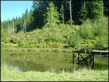
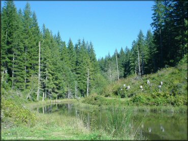
This pond is located near the main entrance. Some people stage here, but if you continue past the pond you'll reach a gravel parking lot.
Blue Ridge Trails Photo
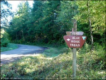
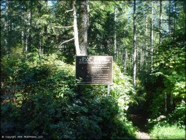
This is the sign marking the main entrance to the area.
Blue Ridge Trails Photo
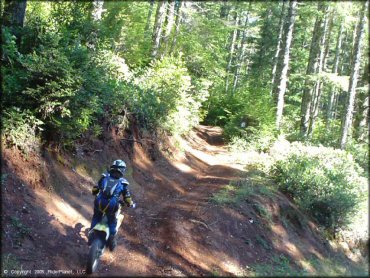
Blue Ridge Trails Photo
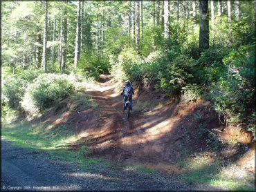
The trails are well maintaned, but they still get muddy.
Blue Ridge Trails Photo
Blue Ridge Trails Photo
Blue Ridge Trails Photo
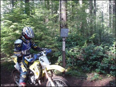
This sign at the main parking area has some rules and regulations and trail information.
Blue Ridge Trails Photo
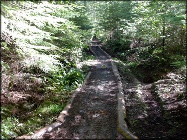
Blue Ridge Trails Photo
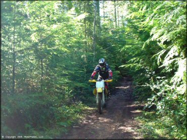
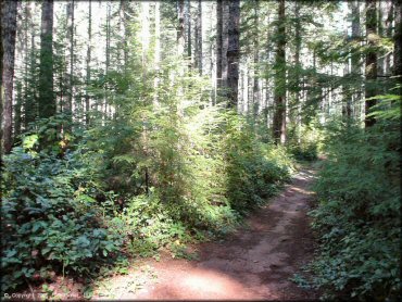
Thick vegetation and some top notch single track.
Blue Ridge Trails Photo
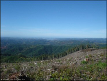
Great scenery.
Blue Ridge Trails Photo
This is the parking and staging area at the main entrance to the trails.
Blue Ridge Trails Photo
RIDER COMMENTS & REVIEWS