 |
      |
| Home > Pennsylvania > Shade Mountain Trail |
Shade Mountain Trail
Saturday, December 23, 2023
| Other Names | Bald Eagle State Forest, Shade Mountain OHM Trail System, Diamond Trail, Deer Spring Trail, Mitchell Trail, Tram Trail, Varner Gap, Shawyerville Trail, Arney Gap, Allen Gap, West Boyer Trail, Dug Trail, Forster Gap, Shellenberger Gap, Richfield Path, Snyder County, Juniata County |
| Last Known Status | Closed For Season |
This area offers miles of enduro style trails that are geared toward the more advanced rider. Trails are marked with purple blazes and terrain mainly consists of rocky sections, steep climbs and sharp off camber turns.
The trail is open to non-street legal motorcycles, but has a seasonal closure that generally begins the Friday before Memorial Day through the last full weekend in September. Call before you haul.
REGULATIONS
| Permit Required | No | |
| Dates Open | Friday before Memorial Day through last full weekend in September | |
| Other ATV Stickers Accepted | Yes | (AR, AZ, CA, CO, CT, DE, IA, ID, IN, LA, MA, ME, MI, MN, MO, MT, ND, NH, NJ, NM, NY, OH, OK, RI, UT, VT, WA, WI) |
| Spark Arrestor | Yes | A spark arresting exhaust silencer or end cap is required for all vehicles. |
| Noise Limit | Yes | |
| Whip Flags | Not Required | |
| Maximum Vehicle Width | ||
 Motorcycles & Dirt Bikes Motorcycles & Dirt Bikes | Permitted | |
 ATVs ATVs | Prohibited | |
 UTV & SXS UTV & SXS | Prohibited | |
 SUVs & Jeeps (registered) SUVs & Jeeps (registered) | Prohibited | |
| Dune Buggy & Sand Rail 4x4 (unregistered) | Prohibited | |
| 2 Stroke Engines | No Restriction | |
| MX Helmet Required | Yes | helmets required by state law |
 Camping Camping | ||
 Campfires Campfires | ||
| Night Riding | Unknown | |
| Trail Blazing | Prohibited | stay on trails |
| Rule Enforcement | ||
| Comment | Licensed dual sport motorcycles can ride on roads and drivable trails open to all license motorized vehicles throughout the year. | |
TERRAIN
| Miles Of Trail | 17 | |
| Climate Type | Forest | |
| Elevation | 1600 to 2100 ft. | |
| Trail Maintenance | Marked, Not Rated, Lightly Maintained | |
| Loose Dirt |  Some Some | |
| Hard Pack |  Mostly Mostly | |
| Sand |  None None | |
| Mud |  Little Little | |
| Dust | Little | |
| Rocks | Mostly | |
| Trees |  All All | |
| Steep Hills | Some | |
| Single Track | All | |
| Hazards |  Few Few | (hazards assumed marked but use caution) |
 Novice Novice | Little | |
 Amateur Amateur | Some | |
 Expert Expert | Mostly | |
| Comment | Motorcycle trails are marked with purple blazes. | |
TYPE OF AREA
| Area | Motorized Trails |
| Land | State Forest |
GPS POINTS

KEY SERVICES
 Gasoline Gasoline | 1-5 Miles (S) | Exxon/Rosewood Market (717) 463-3259 |
| Diesel | 5-20 Miles (SW) | Exxon/Deans Store (717) 463-2411 |
 Water Water | 5-20 Miles (NE) | Shady Brook Campground & Boat Rental (570) 837-9773 |
 RV Hookup RV Hookup | 5-20 Miles (NE) | Shady Brook Campground & Boat Rental (570) 837-9773 |
 RV Disposal RV Disposal | 5-20 Miles (NE) | Shady Brook Campground & Boat Rental (570) 837-9773 |
| Campground | 5-20 Miles (NE) | Shady Brook Campground & Boat Rental (570) 837-9773 |
 Conv Store Conv Store | 1-5 Miles (S) | Exxon/Rosewood Market (717) 463-3259 |
FEES & PASSES
| Parking | (None) |
| Entry | (None) |
| Riding | (None) |
| Camping | (None) |
RATINGS
| Our Rating |  Good Good |
| Recommended Stay | Full Day |
| Comments | (Scroll Down For Rider Reviews & Comments) |
DRIVING DIRECTIONS
| Nearest City | Mcalisterville, PA | ||
| From: Mcalisterville, PA
1) Take SR-235 North about 5.5 miles 2) Staging area is on the right. |


OFFICIAL CONTACTS
| Contact Info | Bald Eagle State Forest 18865 Old Turnpike Road Millmont, PA 17845 (570) 922-3344 fd07@pa.gov www.dcnr.pa.gov |
| Contact Info | Pennsylvania Trail Riders Association 6064 Old Hickory Road Coopersburg, PA 18036 info@patrailriders.org patrailriders.org |
Shade Mountain Trail Photo
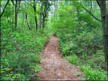
Photo Submitted 8/8/2012 (Thanks!)
Shade Mountain Trail Photo
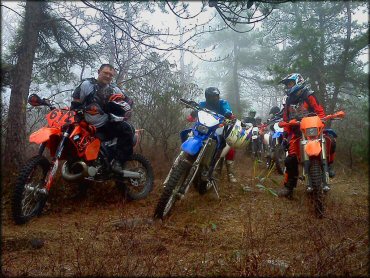
Photo Submitted 8/8/2012 (Thanks!)
Shade Mountain Trail Photo
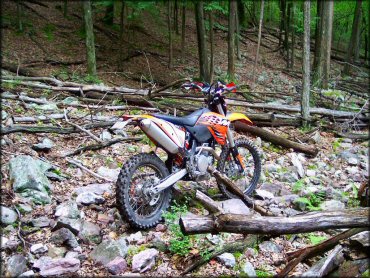
Photo Submitted 8/8/2012 (Thanks!)
Shade Mountain Trail Photo
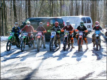
Photo Submitted 8/9/2012 (Thanks!)
Shade Mountain Trail Photo
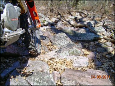
Photo Submitted 8/9/2012 (Thanks!)
RIDER COMMENTS & REVIEWS