 |
      |
| Home > Tennessee > Buffalo Mountain |
Buffalo Mountain ATV Trail
Sunday, March 31, 2024
| Other Names | Buffalo Mountain Park, Buffalo Mountain, Cherokee National Forest, Horse Cove Gap Trailhead, Unicoi County, Cherokee Mountain, Pinnacle Mountain, Straight Creek, Sinking Creek, Briar Creek, Trail #29, Unaka Ranger District, Ramsey Creek |
| Last Known Status | Open |
The Buffalo Mountain ATV Trail (not to be confused with Buffalo Mountain in West Virginia) is the only trail within the Cherokee National Forest that is open to ATVs. The staging area is small and open for day use only but is paved and has a loading ramp and self pay kiosk station.
The trail is linear (one way in, one way out) and is about 13 miles long each way. The trail starts off with a steep climb from the staging area but eventually heads south and follows the ridgeline of Buffalo Mountain. The trails also winds near the Pinnacle Mountain Fire Tower, which can be accessed by a short hiking trail.
The trail has a seasonal closure which usually begins in mid December and ends around late March. Exact dates vary each year, so check with the ranger station before heading out.
Visitors should note that this trail is not recommended for beginner riders due to rocky sections, roots, tree stumps, steep climbs and descents.
REGULATIONS
| Permit Required | No | |
| Dates Open | March - December 15 | |
| Other ATV Stickers Accepted | Unknown | |
| Spark Arrestor | Yes | A spark arresting exhaust silencer or end cap is required for all vehicles. |
| Noise Limit | Yes (96 dB) | |
| Whip Flags | Not Required | |
| Maximum Vehicle Width | Yes (50 inches) | has entrance gate or posts |
 Motorcycles & Dirt Bikes Motorcycles & Dirt Bikes | Permitted | |
 Four Wheelers Four Wheelers | Permitted | (maximum width 50 inches) |
 UTV & SXS UTV & SXS | Permitted | (maximum width 50 inches) |
 SUVs & Jeeps (registered) SUVs & Jeeps (registered) | Prohibited | |
| Dune Buggy & Sand Rail 4x4 (unregistered) | Prohibited | |
| 2 Stroke Engines | No Restriction | |
| MX Helmet Required | Yes | |
 Camping Camping | Prohibited | |
 Campfires Campfires | Prohibited | |
| Night Riding | No | riding hours sunrise to sunset |
| Trail Blazing | Prohibited | stay on trail |
| Rule Enforcement |
TERRAIN
| Approx Size | 2,560 acres (4 sq mi) | |
| Miles Of Trail | 26 | |
| Climate Type | Forest | |
| Elevation | 2400 to 3000 ft. | |
| Trail Maintenance | Marked, Not Rated, Lightly Maintained | |
| Loose Dirt |  Little Little | |
| Hard Pack |  Mostly Mostly | |
| Sand | Little | |
| Mud |  Some Some | |
| Dust | Some | |
| Rocks | Mostly | |
| Trees |  All All | |
| Steep Hills | Some | |
| Small Jumps |  None None | |
| Large Jumps | None | |
| Berms |  Few Few | |
| Sand/Gravel Pits | None | |
| Single Track | None | |
| Shade |  Many Many | |
| Hazards | Few | (hazards assumed marked but use caution) |
 Novice Novice | Little | |
 Amateur Amateur | Mostly | |
 Expert Expert | Some | |
| Comment | Trail is 13 miles long each way. | |
TYPE OF AREA
| Area | Motorized Trails |
| Land | National Forest |


KEY SERVICES
 Gasoline Gasoline | 5-20 Miles (NE) | Shell (423) 928-6273 |
| Diesel | 5-20 Miles (NE) | Shell (423) 928-6273 |
 Water Water | 5-20 Miles (SE) | Rock Creek Recreation Area Campground (423) 638-4109 |
 RV Hookup RV Hookup | 5-20 Miles (SE) | Nolichucky Gorge Campground (423) 743-8876 |
 RV Disposal RV Disposal | 5-20 Miles (SE) | Rock Creek Recreation Area Campground (423) 638-4109 |
| Campground | 5-20 Miles (SE) | Rock Creek Recreation Area Campground (423) 638-4109 |
 Conv Store Conv Store | 5-20 Miles (NE) | Shell (423) 928-6273 |
FEES & PASSES
| Parking | (None) |
| Entry | Yes ($5.00 per vehicle) |
| Riding | (None) |
| Camping | (None) |
RATINGS
| Our Rating |  Good Good |
| Recommended Stay | Full Day |
| Comments | (Scroll Down For Rider Reviews & Comments) |
DRIVING DIRECTIONS
| Nearest City | Johnson City, TN | ||
| Address | Dry Creek Road, Johnson City, TN 37604 | ||
| From: Johnson City, TN
1) Take I-26 South to Exit 24 2) Stay in the left lane and turn left (west) off the exit ramp onto University Pkwy, continue 1.2 miles 3) Turn left (south) onto Hwy 67, continue 2.1 miles 4) Turn left (south-east) onto Lone Oak Road (road name changes to Dry Creek Road), continue 3.5 miles 5) Staging area is on the left (east). |


OFFICIAL CONTACTS
| Contact Info | Cherokee National Forest - Unaka Ranger District 4900 Asheville Hwy SR70 Greenville, TN 37743 (423) 638-4109 mailroom_r8_cherokee@fs.fed.us www.fs.usda.gov |
Buffalo Mountain Trail Photo
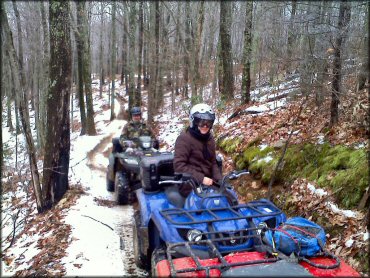
This trail is very popular with the four wheelers. Photo Submitted 7/9/2012 (Thanks!)
Buffalo Mountain Trail Photo
The staging area is surrounded by trees, providing some shade. Photo Submitted 4/20/2013 (Thanks!)
Buffalo Mountain Trail Photo

The main staging area is small but has paved parking. Compact trucks and small trailers only. Photo Submitted 4/20/2013 (Thanks!)
Buffalo Mountain Trail Photo
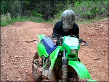
The terrain is mostly hardpacked with loose chunk rock, tree roots, stumps and some steep climbs. This section of the trail smoothed out for a little bit. Photo Submitted 5/4/2013 (Thanks!)
RIDER COMMENTS & REVIEWS