 |
      |
| Home > Texas > Lake Mcclellan |
Lake Mcclellan Recreation Area
Saturday, December 23, 2023
| Other Names | Mcclellan National Grassland, Cibola National Forest, Black Kettle District, Mcclellan Creek |
| Last Known Status | Open |
Overlooking the shores of Lake Mcclellan, this recreation area offers about ten miles of narrow ATV trails with gradual elevation changes and moderate difficulty. The vegetation ranges from open grasslands to a mixed hardwood forest.
Camping is available and there are 60 sites to choose from, many with electric and water hookups plus direct trail access. Both campground and trails are open year-round but the best time to visit is during the spring and fall months. The lake also has a boat ramp and several picnic sites that offers nice views of the area.
REGULATIONS
| Permit Required | Yes | |
| Dates Open | Year-Round | |
| Other ATV Stickers Accepted | No | At this time, there are no reciprocity agreements between Texas and any other states. All visiting riders must purchase a Texas OHV decal. |
| Spark Arrestor | Yes | A spark arresting exhaust silencer or end cap is required for all vehicles. |
| Noise Limit | Yes (96 dB) | |
| Whip Flags | Not Required | |
| Maximum Vehicle Width | Yes (50 inches) | narrow terrain |
 Motorcycles & Dirt Bikes Motorcycles & Dirt Bikes | Permitted | |
 ATVs ATVs | Permitted | (maximum width 50 inches) |
 UTV & SXS UTV & SXS | Permitted | (maximum width 50 inches) |
 SUVs & Jeeps (registered) SUVs & Jeeps (registered) | Prohibited | |
| Dune Buggy & Sand Rail 4x4 (unregistered) | Prohibited | |
| 2 Stroke Engines | No Restriction | |
| MX Helmet Required | Yes | helmets required by state law |
 Camping Camping | Some Areas | (camp in developed sites only) |
 Campfires Campfires | Some Areas | (permitted in developed campsites only) |
| Night Riding | Unknown | |
| Trail Blazing | Prohibited | keep on the trail |
| Rule Enforcement |
TERRAIN
| Approx Size | 1,140 acres (2 sq mi) | |
| Miles Of Trail | 10 | |
| Climate Type | Forest | |
| Elevation | 2900 to 3000 ft. | |
| Trail Maintenance | Marked, Not Rated, Lightly Maintained | |
| Loose Dirt |  Some Some | |
| Hard Pack |  Little Little | |
| Sand | Some | |
| Mud | Little | |
| Dust | Little | |
| Rocks | Little | |
| Trees | Some | |
| Steep Hills |  Few Few | |
| Water Crossings |  None None | |
| Small Jumps | Few | |
| Large Jumps | None | |
| Berms | Some | |
| Sand/Gravel Pits | None | |
| Single Track | None | |
| Roads | None | |
| Shade | Few | |
| Hazards | Few | (hazards assumed marked but use caution) |
 Novice Novice | Some | |
 Amateur Amateur |  Mostly Mostly | |
 Expert Expert | Little |
TYPE OF AREA
| Area | Motorized Trails |
| Land | National Forest |


KEY SERVICES
 Gasoline Gasoline | 5-20 Miles (W) | Texaco (814) 742-7180 |
| Diesel | 5-20 Miles (W) | Texaco (814) 742-7180 |
 Water Water | On Site | |
 RV Hookup RV Hookup | On Site | |
 RV Disposal RV Disposal | On Site | |
| Campground | On Site | |
 Conv Store Conv Store | 5-20 Miles (W) | Texaco (814) 742-7180 |
FEES & PASSES
| Parking | Yes ($3.00) day use parking fee |
| Entry | (None) |
| Riding | Yes ($5.00 per OHV) |
| Camping | Yes Tent: $10.00 RV: $15.00 Addtl. Vehicle: $0.00 tent site - $10/night; electric and water - $15/night |
RATINGS
| Our Rating |  Good Good |
| Recommended Stay | Full Day |
| Comments | (Scroll Down For Rider Reviews & Comments) |
DRIVING DIRECTIONS
| Nearest City | Pampa, TX | ||
| From: Amarillo, TX
1) Take I-40 East to Exit 128 2) Turn left (north) off the exit ramp onto FM-2477, continue about 4 miles 3) Campground entrance is on the left (south). |


OFFICIAL CONTACTS
| Contact Info | Cibola National Forest - Black Kettle District Route 1, Box 55-B Cheyenne, OK 73628-9725 (580) 497-2143 mailroom_r3_cibola@fs.fed.us www.fs.usda.gov |
| Contact Info | Trey Cooksey (OHV Program Manager) Texas Parks And Wildlife 4200 Smith School Road Austin, TX 78744 (512) 389-8743 trey.cooksey@tpwd.texas.gov tpwd.texas.gov |
| Comment | Texas OHV Decal Info |
Lake Mcclellan Trail Photo
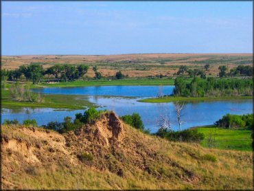
Photo Submitted 10/21/2013 (Thanks!)
Lake Mcclellan Trail Photo
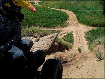
Photo Submitted 6/28/2018 (Thanks!)
Lake Mcclellan Trail Photo
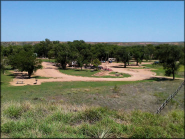
Photo Submitted 6/28/2018 (Thanks!)
Lake Mcclellan Trail Photo
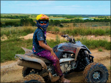
Photo Submitted 6/28/2018 (Thanks!)
Lake Mcclellan Trail Photo
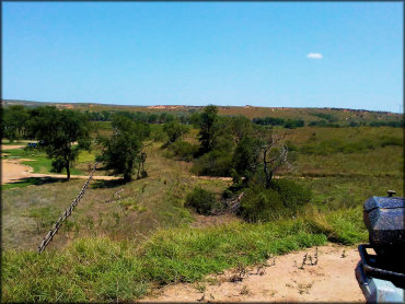
Photo Submitted 6/28/2018 (Thanks!)
Lake Mcclellan Trail Photo
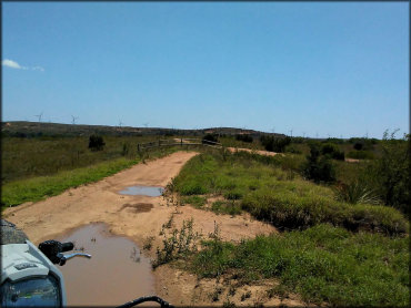
Photo Submitted 6/28/2018 (Thanks!)
RIDER COMMENTS & REVIEWS