 |
      |
| Home > Utah > Skyline Trail |
Skyline Trail
Saturday, December 23, 2023
| Other Names | Skyline Drive, North Ogden Divide Trailhead, Uinta-wasatch-cache National Forest, Ogden Ranger District, Ben Lomond Peak, Pineview Reservoir, Ogden Valley, Willard Peak, Willard Basin, Lewis Peak |
| Last Known Status | Open |
This part of the Uinta-Wasatch-Cache National Forest offers over 20 miles of pure single track trails. The trails can be accessed by the North Ogden Divide Trailhead which offers direct access to the southern trail. The northern section is located across the street from the staging area but is seasonally closed to motorcycles until July 15.
Both northern and southern parts have narrow and sharp switchbacks with some loose chunk rock and overgrown tree roots covering the trail. The trail eventually levels out at the top and offers beautiful panoramic mountain and city views.
REGULATIONS
| Permit Required | Yes | UT OHV Sticker |
| Dates Open | Year-Round | |
| Other ATV Stickers Accepted | No | Non-residents must purchase a non-resident OHV permit. |
| Spark Arrestor | Yes | A spark arresting exhaust silencer or end cap is required for all vehicles. |
| Noise Limit | Yes | |
| Whip Flags | Not Required | |
| Maximum Vehicle Width | ||
 Motorcycles & Dirt Bikes Motorcycles & Dirt Bikes | Permitted | |
 ATVs ATVs | Prohibited | |
 UTV & SXS UTV & SXS | Prohibited | |
 SUVs & Jeeps (registered) SUVs & Jeeps (registered) | Prohibited | |
| Dune Buggy & Sand Rail 4x4 (unregistered) | Prohibited | |
| 2 Stroke Engines | No Restriction | |
 Camping Camping | ||
 Campfires Campfires | ||
| Night Riding | Unknown | |
| Trail Blazing | Prohibited | riders must stay on trail |
| Rule Enforcement |
TYPE OF AREA
| Area | Motorized Trails |
| Land | National Forest |
FEES & PASSES
| Parking | (None) |
| Entry | (None) |
| Riding | (None) |
| Camping | (None) |
RATINGS
| Our Rating |  Very Good Very Good |
| Recommended Stay | Full Day |
| Comments | (Scroll Down For Rider Reviews & Comments) |
DRIVING DIRECTIONS
| Nearest City | Ogden, UT | ||
| From: Salt Lake City, UT
1) Take I-15 north to Exit 352 2) Turn right (east) onto SR-134, continue 1 mile 3) Turn right (south) onto US-89, continue .2 miles 4) Turn left (east) onto SR-235, continue 2 miles 5) Turn left (north) onto Washington Blvd, continue .1 miles 6) Turn right (east) onto E. 2600 N, continue 1.1 miles 7) Turn left (north) onto N. 1050, continue .7 miles 8) Turn right (east) onto North Ogden Canyon Road, contine 3.8 miles 9) Staging area is on the right (south). |


OFFICIAL CONTACTS
| Contact Info | Uinta-wasatch-cache National Forest - Ogden Ranger District 507 25th Street, Suite 103 Ogden, UT 84401 (801) 625-5112 mailroom_r4_uinta@fs.fed.us www.fs.usda.gov |
| Contact Info | Utah State Parks OHV Education Office 1594 W North Temple, Suite 116 Salt Lake City, UT 84116 (800) 648-7433 ohveducation@utah.gov stateparks.utah.gov |
Skyline Trail Photo
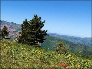
Photo Submitted 6/2/2018 (Thanks!)
Skyline Trail Photo
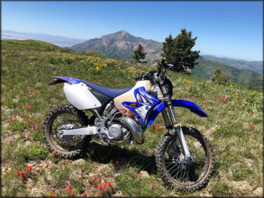
Photo Submitted 6/2/2018 (Thanks!)
ADD PHOTOS
TERRAIN
| Miles Of Trail | 20 | |
| Climate Type | Forest | |
| Elevation | 6200 to 9600 ft. | |
| Trail Maintenance | Marked, Not Rated, Lightly Maintained | |
| Loose Dirt |  Little Little | |
| Hard Pack |  Mostly Mostly | |
| Sand |  None None | |
| Mud | Little | |
| Dust | Little | |
| Rocks |  Some Some | |
| Trees |  All All | |
| Steep Hills |  Many Many | |
| Small Jumps | None | |
| Large Jumps | None | |
| Berms |  Few Few | |
| Sand/Gravel Pits | None | |
| Single Track | All | |
| Roads | None | |
| Shade | Many | |
| Hazards | Few | (hazards assumed marked but use caution) |
 Novice Novice | Little | |
 Amateur Amateur | Mostly | |
 Expert Expert | Some |
GPS POINTS


KEY SERVICES
 Gasoline Gasoline | 5-20 Miles (W) | 7-11 (801) 782-9673 |
| Diesel | 5-20 Miles (W) | 7-11 (801) 782-9673 |
 Water Water | 5-20 Miles (NW) | Anderson Cove Campground (877) 444-6777 |
 RV Hookup RV Hookup | 5-20 Miles (SE) | Anderson Cove Campground (877) 444-6777 |
 RV Disposal RV Disposal | 5-20 Miles (SE) | Anderson Cove Campground (877) 444-6777 |
| Campground | 5-20 Miles (SE) | Anderson Cove Campground (877) 444-6777 |
 Conv Store Conv Store | 5-20 Miles (W) | 7-11 (801) 782-9673 |
RIDER COMMENTS & REVIEWS