 |
      |
| Home > Utah > Wasatch Mountain |
Wasatch Mountain State Park
Saturday, December 23, 2023
| Other Names | Cascade Springs, Mill Flat, Little Deer Creek Campground, Wasatch Mountains, Provo Deer Creek, Lundeen Creek, Soldier Hollow, Heber Valley |
| Last Known Status | Open |
This state forest offers about 30 miles of ATV trails. Those with dual sport motorcycle can keep heading west and tie into the Tibble Fork singletrack. The trails are mostly hardpacked with moderate elevation changes but winds through a nice mix of beautiful forests and high mountain desert.
The trail system has two designated day use staging areas and a primitive campground with direct trail access. The trails are open year-round, and during the winter months can be explored by snowmobiles when conditions allow.
REGULATIONS
| Permit Required | Yes | UT OHV Sticker |
| Dates Open | Year-Round | |
| Other ATV Stickers Accepted | No | Non-residents must purchase a non-resident OHV permit. |
| Spark Arrestor | Yes | A spark arresting exhaust silencer or end cap is required for all vehicles. |
| Noise Limit | ||
| Whip Flags | Not Required | |
| Maximum Vehicle Width | No Restriction | |
 Motorcycles & Dirt Bikes Motorcycles & Dirt Bikes | Permitted | |
 ATVs ATVs | Permitted | |
 UTV & SXS UTV & SXS | Permitted | |
 SUVs & Jeeps (registered) SUVs & Jeeps (registered) | Permitted | |
| Dune Buggy & Sand Rail 4x4 (unregistered) | Prohibited | |
| 2 Stroke Engines | No Restriction | |
 Camping Camping | Some Areas | (camp in developed sites only) permitted at Little Deer Creek Campground |
 Campfires Campfires | Some Areas | (permitted in developed campsites only) |
| Night Riding | No | |
| Trail Blazing | Prohibited | stay on trails |
| Rule Enforcement |
TYPE OF AREA
| Area | Motorized Trails |
| Land | State Forest |
FEES & PASSES
| Parking | (Unknown) |
| Entry | (None) |
| Riding | (None) |
| Camping | Yes Tent: $14.00 RV: $14.00 Addtl. Vehicle: $0.00 Little Deer Creek Campground Fee |
RATINGS
| Our Rating |  Good Good |
| Recommended Stay | Full Day |
| Comments | (Scroll Down For Rider Reviews & Comments) |
DRIVING DIRECTIONS
| Nearest City | Midway, UT | ||
| From: Salt Lake City, UT
For the Cascade Springs Staging Area: 1) Take I-80 east to exit 146 2) Merge onto US-189 south, continue about 20 miles 3) Turn right (south-west) onto River Road, continue about 13 miles 4) Turn right (west) onto Main Street, continue .4 miles 5) Turn left (south) onto Center Street, continue 1.8 miles 6) Turn right (west) onto Tate Lane, continue .5 miles 7) Turn right (north) onto Stringtown Road, continue .3 miles 8) Turn left (west) onto Cascade Springs Drive, continue about .5 miles 9) Staging area is on the right (north). For Little Deer Creek Campground: 1) Continue west on Cascade Springs Drive about .8 miles 2) Veer right (north-west) onto Cummings Parkway, continue .7 miles 3) Veer right (north) onto Deer Creek Campground Road, continue about 1 mile 4) Campground entrance is on the left (west). |

OFFICIAL CONTACTS
| Contact Info | Wasatch Mountain State Park P.O. Box 10 Midway, UT 84049 (435) 654-1791 wasatchintern@gmail.com stateparks.utah.gov |
| Contact Info | Utah State Parks And Recreation (800) 322-3770 parkcomment@utah.gov utahstateparks.reserveamerica.com |
| Comment | Little Deer Creek Campground Reservations |
| Contact Info | Lofty Peaks Adventures 845 S Main Street Heber City, UT 84032 (435) 654-7455 info@loftypeaks.com www.loftypeaks.com |
| Contact Info | Utah State Parks OHV Education Office 1594 W North Temple, Suite 116 Salt Lake City, UT 84116 (800) 648-7433 ohveducation@utah.gov stateparks.utah.gov |
| Comment | OHV Permit Info |
Wasatch Mountain Trail Photo
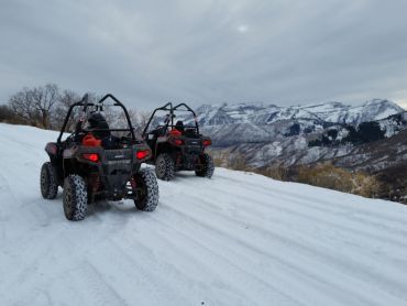
Photo Submitted 12/13/2015 (Thanks!)
Wasatch Mountain Trail Photo
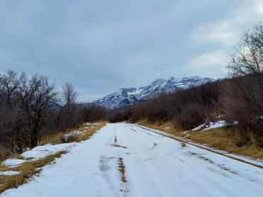
Photo Submitted 12/13/2015 (Thanks!)
ADD PHOTOS
TERRAIN
| Approx Size | 23,000 acres (36 sq mi) | |
| Miles Of Trail | 30 | |
| Climate Type | Forest | |
| Elevation | 5500 to 8000 ft. | |
| Trail Maintenance | Marked, Not Rated, Lightly Maintained | |
| Loose Dirt |  Little Little | |
| Hard Pack |  Mostly Mostly | |
| Sand |  None None | |
| Mud | Little | |
| Dust |  Some Some | |
| Rocks | Little | |
| Trees |  All All | |
| Steep Hills |  Few Few | |
| Water Crossings | Some | |
| Small Jumps | None | |
| Large Jumps | None | |
| Berms | Few | |
| Sand/Gravel Pits | None | |
| Single Track | None | |
| Roads | Some | |
| Shade | Some | |
| Hazards | Few | (hazards assumed marked but use caution) |
 Novice Novice | Mostly | |
 Amateur Amateur | Some | |
 Expert Expert | Little |
GPS POINTS


KEY SERVICES
 Gasoline Gasoline | 5-20 Miles (N) | Chevron (435) 654-6673 |
| Diesel | 5-20 Miles (N) | Chevron (435) 654-6673 |
 Water Water | On Site | Little Deer Creek Campground (435) 654-3961 |
 RV Hookup RV Hookup | 5-20 Miles (N) | Pine Creek Campground (435) 654-3961 |
 RV Disposal RV Disposal | 5-20 Miles (N) | Pine Creek Campground (435) 654-3961 |
| Campground | On Site | Little Deer Creek Campground (435) 654-3961 |
 Conv Store Conv Store | 5-20 Miles (N) | Chevron (435) 654-6673 |
RIDER COMMENTS & REVIEWS