 |
      |
| Home > Virginia > Virginia Highlands |
Virginia Highlands Horse Trail
Thursday, April 11, 2024
| Other Names | Jefferson National Forest, Little Mountain, Kirk Hollow, Snake Den Mountain, Granny Creek, Mount Rogers National Recreation Area, Blue Ridge Highlands |
| Last Known Status | Open |
This trail winds through a mixed hardwood forest and consists of double track, several creek crossings, narrow single track and plenty of scenic views of the surrounding mountains and valleys.
Visitors should note that while the total length of the trail is 67 miles, the only segment that is open to motorcycles is between Hwy 21 and Hwy 16 which is a little over 23 miles long.
The trail is open seasonally to street legal motorcycles from October through April 1 but is open year-round to non-motorized use.
REGULATIONS
| Permit Required | No | motorcycles must be street legal and tagged from VA DMV |
| Dates Open | October - April 1 | |
| Other ATV Stickers Accepted | Unknown | |
| Spark Arrestor | Yes | A spark arresting exhaust silencer or end cap is required for all vehicles. |
| Noise Limit | Yes (96 dB) | |
| Whip Flags | Not Required | |
| Maximum Vehicle Width | ||
 Motorcycles & Dirt Bikes Motorcycles & Dirt Bikes | Certain Times | permitted October through April 1 |
 ATVs ATVs | Prohibited | |
 UTV & SXS UTV & SXS | Prohibited | |
 SUVs & Jeeps (registered) SUVs & Jeeps (registered) | Prohibited | |
| Dune Buggy & Sand Rail 4x4 (unregistered) | Prohibited | |
| 2 Stroke Engines | No Restriction | |
| MX Helmet Required | Yes | helmets required by state law |
 Camping Camping | Some Areas | (camp in developed sites only) |
 Campfires Campfires | ||
| Night Riding | Unknown | |
| Trail Blazing | Prohibited | vehicles must stay on trail |
| Rule Enforcement |
TYPE OF AREA
| Area | Motorized Trails |
| Land | National Forest, Nat Recreation |
FEES & PASSES
| Parking | (None) |
| Entry | (None) |
| Riding | (None) |
| Camping | Yes Tent: $14.00 RV: $18.00 Addtl. Vehicle: $0.00 Raccoon Branch Campground Fees |
RATINGS
| Our Rating |  Good Good |
| Recommended Stay | Full Day |
| Comments | (Scroll Down For Rider Reviews & Comments) |
DRIVING DIRECTIONS
| Nearest City | Sugar Grove, VA | ||
| From: Marion, VA
1) Take I-81 to Exit 45 2) Turn south off the exit ramp onto SR-16, continue 9.5 miles 3) Turn left (south-east) onto SR-601/Flat Ridge Road, continue 1.3 miles 4) Turn left (east) onto FS-857, continue about 1 mile 5) Trailhead is on the right. |


OFFICIAL CONTACTS
| Contact Info | Mount Rogers National Recreation Area 3714 Highway 16 Marion, VA 24354 (276) 783-5196 (800) 628-7202 mailroom_r8_george_washington_jefferson@fs.fed.us www.fs.usda.gov |
Virginia Highlands Trail Photo
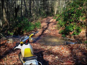
Photo Submitted 11/25/2014 (Thanks!)
Virginia Highlands Trail Photo
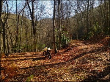
Photo Submitted 11/25/2014 (Thanks!)
Virginia Highlands Trail Photo
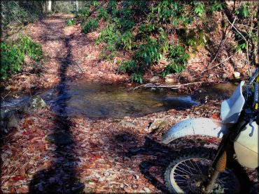
Photo Submitted 11/25/2014 (Thanks!)
ADD PHOTOS
TERRAIN
| Miles Of Trail | 23 | |
| Climate Type | Forest | |
| Elevation | 2900 to 3500 ft. | |
| Trail Maintenance | Marked, Not Rated, Lightly Maintained | trail is marked with orange paint blazes |
| Loose Dirt |  Mostly Mostly | |
| Hard Pack |  Some Some | |
| Sand |  None None | |
| Mud |  Little Little | |
| Dust | Little | |
| Rocks | Some | |
| Trees |  All All | |
| Steep Hills |  Few Few | |
| Water Crossings | Some | |
| Small Jumps | None | |
| Large Jumps | None | |
| Berms | Few | |
| Sand/Gravel Pits | None | |
| Single Track |  Many Many | |
| Roads | None | |
| Shade | Many | |
| Hazards | Few | (hazards assumed marked but use caution) |
 Novice Novice | Mostly | |
 Amateur Amateur | Some | |
 Expert Expert | Little |
GPS POINTS


KEY SERVICES
 Gasoline Gasoline | 1-5 Miles (NW) | Exxon (276) 677-3037 |
| Diesel | 1-5 Miles (NW) | Exxon (276) 677-3037 |
 Water Water | 5-20 Miles (SW) | Raccoon Branch Campground (800) 628-7202 |
 RV Hookup RV Hookup | 5-20 Miles (SW) | Raccoon Branch Campground (800) 628-7202 |
 RV Disposal RV Disposal | 5-20 Miles (SW) | Raccoon Branch Campground (800) 628-7202 |
| Campground | 5-20 Miles (SW) | Raccoon Branch Campground (800) 628-7202 |
 Conv Store Conv Store | 1-5 Miles (NW) | Exxon (276) 677-3037 |
RIDER COMMENTS & REVIEWS