 |
      |
| Home > Wisconsin > Dead Horse Run |
Dead Horse Run Trail
Friday, March 8, 2024
| Other Names | Clam Lake, Camp Loretta, Day Lake, Stock Farm Bridge, Chippewa River, Chequamegon-Nicolet National Forest, Great Divide Ranger District, Sawyer County, Deadhorse Run |
| Last Known Status | Temporarily Closed (closed for spring thaw) |
This area offers about 63 miles of hard packed and level ATV trails that wind through a scenic forest that consists of various maple, oak, aspen and birch trees. Foxes, raccoons, rabbits and white-tailed deer are among the wildlife that can be found throughout the forest. The name "Dead Horse" comes from an unfortunate event back in 1900 when a team of horses fell through ice and perished.
Camp Loretta is the suggested staging area for large trailers since it has plenty of room for parking while the northeastern Dead Horse Slough trailhead offers a smaller staging area. There is no fee for camping but there is a small day use fee charged for parking.
The trails are open daily except during spring thaw which begins around mid March through the end of April. Exact dates vary so call first before heading out.
REGULATIONS
| Permit Required | Yes | WI ATV Permit |
| Dates Open | May - March 14 (weather permitting) | |
| Other ATV Stickers Accepted | No | Wisconsin registration or a Nonresident Trail Pass required. |
| Spark Arrestor | Yes | A spark arresting exhaust silencer or end cap is required for all vehicles. |
| Noise Limit | Yes (96 dB) | |
| Whip Flags | Not Required | |
| Maximum Vehicle Width | Yes (65 inches) | has entrance gate or posts |
 Motorcycles & Dirt Bikes Motorcycles & Dirt Bikes | Permitted | |
 ATVs ATVs | Permitted | |
 UTV & SXS UTV & SXS | Permitted | (maximum width 65 inches) |
 SUVs & Jeeps (registered) SUVs & Jeeps (registered) | Prohibited | |
| Dune Buggy & Sand Rail 4x4 (unregistered) | Prohibited | |
| 2 Stroke Engines | No Restriction | |
 Camping Camping | Some Areas | (camp in developed sites only) |
 Campfires Campfires | ||
| Night Riding | Unknown | |
| Trail Blazing | Prohibited | stay on trails |
| Rule Enforcement |
TYPE OF AREA
| Area | Motorized Trails |
| Land | National Forest |
FEES & PASSES
| Parking | Yes ($5.00) Annual Pass - $20 |
| Entry | (None) |
| Riding | (None) |
| Camping | (None) |
RATINGS
| Our Rating |  Good Good |
| Recommended Stay | 1-2 Days |
| Comments | (Scroll Down For Rider Reviews & Comments) |
DRIVING DIRECTIONS
| Nearest City | Fifield, WI | ||
| From: Fifield, WI
1) Take SR-70 West 23 miles 2) Turn right (north) onto CR-GG, continue 2.6 miles 3) Turn left (west) onto FS Road 621, continue .2 miles to staging area. |


OFFICIAL CONTACTS
| Contact Info | Chequamegon National Forest - Great Divide Ranger District N22223 Hwy. 13 Glidden, WI 54527 (715) 634-4821 (715) 264-2511 sm.fs.cnnfadmin@usda.gov www.fs.usda.gov |
| Contact Info | Wisconsin DNR P.O. Box 78701 Milwaukee, WI 53278-0701 (888) 936-7463 dnrfb@wisconsin.gov dnr.wisconsin.gov |
| Comment | ATV and UTV Permit Info |
Dead Horse Run Trail Photo
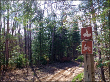
Photo Submitted 5/23/2016 (Thanks!)
Dead Horse Run Trail Photo
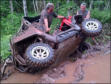
Photo Submitted 11/6/2013 (Thanks!)
ADD PHOTOS
TERRAIN
| Approx Size | 85,000 acres (133 sq mi) | |
| Miles Of Trail | 63 | |
| Climate Type | Forest | |
| Elevation | 1400 to 1500 ft. | |
| Trail Maintenance | Marked, Not Rated, Lightly Maintained | |
| Loose Dirt |  Little Little | |
| Hard Pack |  Mostly Mostly | |
| Sand | Little | |
| Mud |  Some Some | |
| Dust |  None None | |
| Rocks | Some | |
| Trees |  All All | |
| Steep Hills |  Few Few | |
| Water Crossings | Some | |
| Small Jumps | None | |
| Large Jumps | None | |
| Berms | None | |
| Sand/Gravel Pits | None | |
| Single Track | None | |
| Roads | None | |
| Shade | All | |
| Hazards | Few | (hazards assumed marked but use caution) |
 Novice Novice | Some | |
 Amateur Amateur | Mostly | |
 Expert Expert | Little |
GPS POINTS


KEY SERVICES
 Gasoline Gasoline | 20-30 Miles (E) | Fifield Station (715) 762-8844 |
| Diesel | Fifield, WI | |
 Water Water | Fifield, WI | |
 RV Hookup RV Hookup | 20-30 Miles (W) | Lake Chippewa Campground (715) 462-3672 |
 RV Disposal RV Disposal | 20-30 Miles (W) | Lake Chippewa Campground (715) 462-3672 |
| Campground | On Site | Camp Loretta |
 Conv Store Conv Store | 5-20 Miles (SW) | BP Food Mart (715) 266-7676 |
RIDER COMMENTS & REVIEWS