 |
      |
| Home > Massachusetts |

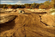
 508 Intl
Status: Variable Schedule (open during select weekends)
Type: Combo (Privately Owned / Commercial)
Location: Charlton, MA
Difficulty:

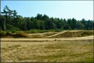
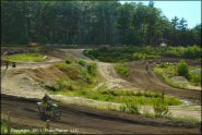
This off-road park features a motocross track with a two minute lap time, a peewee track, 1/4 mile clay flat track plus a 4x4 rock crawl course for all vehicle types. More...
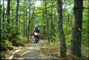
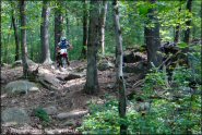
 Beartown State Forest
 Status: Closed For Season
Type: Trail (State Forest)
Location: Monterey, MA
Difficulty:
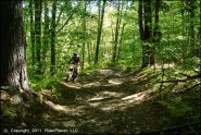
This state forest offers 16.4 miles of challenging ATV trails that consists mostly of loose and chunk rock, mud puddles, tree roots and steep uphill and downhill sections. More...
 Bonny Rigg Campground
 Status: Closed For Season
Type: Trail (Privately Owned / Commercial)
Location: Becket, MA
Difficulty:
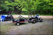
Bonny Rigg Campground offers spacious RV and tent sites and a couple miles of rocky ATV trails that form a short loop through a mixed hardwood forest. More...

 Capeway Rovers Motocross
 Status: Closed For Season
Type: Track (Privately Owned / Commercial)
Location: Middleboro, MA
Difficulty:
This renowned motocross park is claimed to be the oldest track on the east coast. More...
 Crow Hill Motor Sports Park L.L.C
Status: Open
Type: Combo (Privately Owned / Commercial)
Location: Baldwinville, MA
Difficulty:
This wooded park offers a full size motocross track and a peewee track. More...
 Diamond MX
 Status: Open
Type: Track (Privately Owned / Commercial)
Location: Wareham, MA
Difficulty:
Located on a cranberry bog behind Wareham Cycle Center, this motocross track is about one mile long and mainly consists of sand, some hard packed dirt, wood chips and pond silt worked in. More...
 F. Gilbert Hills State Forest
 Status: Closed For Season
Type: Trail (State Forest)
Location: Wrentham, MA
Difficulty:
This dense pine and oak forest has about 8 miles of rocky single track and 23 miles of non-motorized trails. More...
 Franklin Trails
 Status: Closed For Season
Type: Trail (State Forest)
Location: Franklin, MA
Difficulty:
This wooded area in southeastern Massachusetts has just a few miles of fairly easy and flat single track. More...
 Freetown-Fall River State Forest
 Status: Closed For Season
Type: Trail (State Forest)
Location: Fall River, MA
Difficulty:

This state forest boasts 25 miles of single track motorcycle-only trails that range from moderate to very difficult with some nice forest scenery. More...
(Page 1 of 3)

Trail Opening Next Week
Wrentham Trails
Wrentham Trails is expected to open on Wednesday, May 1, 2024.
Details... Map...Trail Opening Next Week
Pittsfield State Forest
Pittsfield State Forest is expected to open on Wednesday, May 1, 2024.
Details... Map...Trail Opening Next Week
Beartown State Forest
Beartown State Forest is expected to open on Wednesday, May 1, 2024.
Details... Map...Trail Opening Next Week
Franklin Trails
Franklin Trails is expected to open on Wednesday, May 1, 2024.
Details... Map...Trail Opening Next Week
Bonny Rigg Campground
Bonny Rigg Campground is expected to open on Wednesday, May 1, 2024.
Details... Map...Trail Opening Next Week
F. Gilbert Hills State Forest
F. Gilbert Hills State Forest is expected to open on Wednesday, May 1, 2024.
Details... Map...Trail Opening Next Week
October Mountain State Forest
October Mountain State Forest is expected to open on Wednesday, May 1, 2024.
Details... Map...Trail Opening Next Week
Tolland State Forest
Tolland State Forest is expected to open on Wednesday, May 1, 2024.
Details... Map...(Page 1 of 3)