 |
      |
| Home > Arkansas > Buckhorn |
Buckhorn OHV Trail System
Tuesday, August 19, 2025
| Other Names | Ozark National Forest, Boston Mountain Ranger District, Lee Creek, Fall Creek, Buckhorn Creek, Cove Creek |
| Last Known Status | Open |
This part of the Ozark National Forest offers two main loops with several short cuts that go near small caves and waterfalls. The area features a wide variety of scenery that ranges from mountain views, rolling hills and valleys covered in a variety of hardwood trees. Most of terrain is hard packed dirt and clay with loose chunk rock and light to moderate elevation changes. There are a few creek crossings but depending on the time of year and amount of rainfall, crossings can get very deep.
The main staging area off Lee Creek Road offers access to the center of the trail system, but the eastern loop can be accessed off Freedom Road and the western loop off of Cove Creek Crossing Road. The main staging area offers graveled parking and forms a loop, making it easy for trailers to get in and out. There is one vault toilet but no other services, some come prepared.
The trail system is open daily, year-round but for current water levels contact the Boston Mountain Ranger District. The Forest Service is looking to make future improvements to trailheads and stream crossings by 2022, so be sure to say thanks for all their hard work.
REGULATIONS
| Permit Required | No | |
| Dates Open | Year-Round | |
| Other ATV Stickers Accepted | Unknown | |
| Spark Arrestor | Yes | A spark arresting exhaust silencer or end cap is required for all vehicles. |
| Noise Limit | Yes (96 dB) | |
| Whip Flags | Not Required | |
| Maximum Vehicle Width | Yes (72 inches) | has entrance gate or posts |
 Motorcycles & Dirt Bikes Motorcycles & Dirt Bikes | Permitted | |
 ATVs ATVs | Permitted | |
 UTV & SXS UTV & SXS | Permitted | |
 SUVs & Jeeps (registered) SUVs & Jeeps (registered) | Prohibited | |
| Dune Buggy & Sand Rail 4x4 (unregistered) | Prohibited | |
| 2 Stroke Engines | No Restriction | |
| MX Helmet Required | Yes | |
 Camping Camping | Some Areas | (camp in developed sites only) |
 Campfires Campfires | Some Areas | (permitted in developed campsites only) |
| Night Riding | Unknown | Not Recommended |
| Trail Blazing | Prohibited | keep on the trail |
| Rule Enforcement | ||
| Comment | Arkansas residents are required to register all 3 and 4-wheeled OHVs with the AR Department of Revenue. Decal is not a forest pass, it fulfills state requirements only. Arkansas residents can call their county revenue department for more information. | |
TERRAIN
| Miles Of Trail | 60 | |
| Climate Type | Forest | |
| Elevation | 900 to 1200 ft. | |
| Trail Maintenance | Marked, Not Rated, Lightly Maintained | Trails are marked with orange and red diamonds. |
| Loose Dirt |  None None | |
| Hard Pack |  Mostly Mostly | |
| Sand | None | |
| Mud |  Some Some | |
| Dust | Some | |
| Rocks | Some | |
| Trees |  All All | |
| Steep Hills |  Few Few | |
| Water Crossings | Some | |
| Small Jumps | None | |
| Large Jumps | None | |
| Berms | None | |
| Sand/Gravel Pits | None | |
| Single Track | None | |
| Roads | Few | |
| Shade | All | |
| Hazards | Few | (hazards assumed marked but use caution) |
 Novice Novice | Some | |
 Amateur Amateur | Mostly | |
 Expert Expert |  Little Little |
TYPE OF AREA
| Area | Motorized Trails |
| Land | National Forest |
GPS POINTS


KEY SERVICES
 Gasoline Gasoline | 5-20 Miles (S) | Cedarville Convenience Store (479) 474-1420 |
| Diesel | 5-20 Miles (S) | Cedarville Convenience Store (479) 474-1420 |
 Water Water | 20-30 Miles (S) | Parkridge Campground (479) 410-4678 |
 RV Hookup RV Hookup | 20-30 Miles (S) | Parkridge Campground (479) 410-4678 |
 RV Disposal RV Disposal | 20-30 Miles (S) | Parkridge Campground (479) 410-4678 |
| Campground | On Site | |
 Conv Store Conv Store | 5-20 Miles (S) | Cedarville Convenience Store (479) 474-1420 |
FEES & PASSES
| Parking | (None) |
| Entry | (None) |
| Riding | Yes ($3.00 per rider) |
| Camping | (None) |
| Comment | No day use fee at staging areas but a donation tube available to help maintain parking, trails and vault toilets. |
RATINGS
| Our Rating |  Good Good |
| Recommended Stay | Full Day |
| Comments | (Scroll Down For Rider Reviews & Comments) |
DRIVING DIRECTIONS
| Nearest City | Lee Creek, AR | ||
| Address | North Lee Creek Road, Chester, AR 72934 | ||
| From: Fort Smith, AR
1) Take SR-59 North about 12 miles 2) Veer right (north-east) onto SR-220, continue about 11 miles 3) Staging area is on the right (east). |


OFFICIAL CONTACTS
| Contact Info | Ozark National Forest - Boston Mountain Ranger District 1903 N. 18th Street Ozark, AR 72949 (479) 667-2191 mailroom_r8_ozark@fs.fed.us www.fs.usda.gov |
Buckhorn Trail Photo
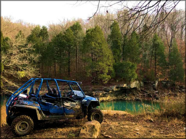
Photo Submitted 12/3/2017 (Thanks!)
Buckhorn Trail Photo
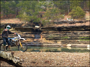
Photo Submitted 12/7/2016 (Thanks!)
Buckhorn Trail Photo
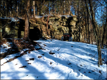
Photo Submitted 1/30/2017 (Thanks!)
Buckhorn Trail Photo
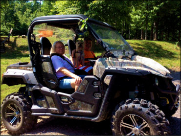
Photo Submitted 5/9/2018 (Thanks!)
RIDER COMMENTS & REVIEWS