 |
      |
| Home > Connecticut > Pachaug State Forest |
Pachaug State Forest
Saturday, May 10, 2025
| Other Names | Mt. Misery, Sawmill Pond, Pachaug River, Hodge Pond, Stanton Pond, Chapman Hill, NETRA Pachaug Enduro Loop, NETRA E8, Pachuag State Forest, Green Falls |
| Last Known Status | Open |
This large state forest offers about 58 miles of motorcycle trails that form a long loop. Most of the trails have light to moderate elevation changes with some tree roots, ruts and rocks. During dry weather the trails can get a bit dusty.
There is a designated staging area off Spaulding Road but if you're looking for camping that is a short distance from the trails try Mt. Misery Campground. This campground features 22 sites that come with a picnic table and fire ring. Several vault toilets and water spigots are also provided. Sites are back-in and can accommodate trailers up to 26 feet. Reservations are required which can be made online.
There is no fee charged to ride but motorcycles must be street legal and registered. Please note that only trails marked with red arrows are open to motorized use. Trails marked in blue are for hiking and those marked with orange signs are for equestrian use.
This trail system is open daily year-round except during mud season. Call for current conditions.
REGULATIONS
| Permit Required | No | motorcycles must be street legal and riders licensed |
| Dates Open | open daily except during mud season | |
| Other ATV Stickers Accepted | Unknown | |
| Spark Arrestor | Yes | A spark arresting exhaust silencer or end cap is required for all vehicles. |
| Noise Limit | ||
| Whip Flags | Not Required | |
| Maximum Vehicle Width | ||
 Motorcycles & Dirt Bikes Motorcycles & Dirt Bikes | Permitted | street legal motorcycles only |
 ATVs ATVs | Prohibited | |
 UTV & SXS UTV & SXS | Prohibited | |
 SUVs & Jeeps (registered) SUVs & Jeeps (registered) | Prohibited | |
| Dune Buggy & Sand Rail 4x4 (unregistered) | Prohibited | |
| 2 Stroke Engines | No Restriction | |
 Camping Camping | Some Areas | (camp in developed sites only) permitted at Mt. Misery Campground |
 Campfires Campfires | Some Areas | (permitted in developed campsites only) permitted at Mt. Misery Campground |
| Night Riding | Unknown | |
| Trail Blazing | Prohibited | keep on the trail |
| Alcohol | Prohibited | |
| Rule Enforcement |
TERRAIN
| Approx Size | 22,938 acres (36 sq mi) | |
| Miles Of Trail | 58 | |
| Climate Type | Forest | |
| Elevation | 200 to 500 ft. | |
| Trail Maintenance | Marked, Not Rated, Lightly Maintained | trails marked with red arrows attached to trees |
| Loose Dirt |  Some Some | |
| Hard Pack |  Mostly Mostly | |
| Sand |  None None | |
| Mud | Mostly | |
| Dust | None | |
| Rocks | Some | |
| Trees |  All All | |
| Water Crossings | Some | |
| Berms |  Few Few | |
| Sand/Gravel Pits | None | |
| Single Track | Some | |
| Roads | Mostly | |
| Intersections | Some | |
| Rider Traffic | Some | |
| Shade | All | |
| Hazards | Few | (hazards not marked) |
 Novice Novice | Some | |
 Amateur Amateur | Mostly | |
 Expert Expert |  Little Little |
TYPE OF AREA
| Area | Motorized Trails |
| Land | State Forest |
GPS POINTS


KEY SERVICES
 Gasoline Gasoline | 1-5 Miles (S) | Chucky's Country Store (860) 376-5943 |
| Diesel | 1-5 Miles (S) | Chucky's Country Store (860) 376-5943 |
 Water Water | On Site | Mt. Misery Campground (860) 424-3200 |
 RV Hookup RV Hookup | 1-5 Miles (SE) | Nature's Campsites (860) 376-4203 |
 RV Disposal RV Disposal | 1-5 Miles (SE) | Nature's Campsites (860) 376-4203 |
| Campground | On Site | Mt. Misery Campground (860) 424-3200 |
 Conv Store Conv Store | 1-5 Miles (S) | Chucky's Country Store (860) 376-5943 |
FEES & PASSES
| Parking | (None) |
| Entry | (None) |
| Riding | (None) |
| Camping | Yes Tent: $17.00 RV: $17.00 Addtl. Vehicle: $0.00 Mt. Misery Campground fee for residents - $17/night, non-residents - $24/night. Reservations required - (877) 668-2267 or (860) 376-4075. |
RATINGS
| Pros | scenic forest, miles of woods trails |
| Cons | must be street legal and licensed, no ATV trails |
| Our Rating |  Good Good |
| Recommended Stay | 1-2 Days |
| Comments | (Scroll Down For Rider Reviews & Comments) |
DRIVING DIRECTIONS
| Nearest City | Voluntown, CT | ||
| Address | Spaulding Road, Plainfield, CT 06374 | ||
| From: Norwich, CT
1) Take I-395 North to Exit 29 2) Turn right (east) off the exit ramp onto SR-14A, continue 1.5 miles 3) Turn right (south) onto Spaulding Road, continue .9 miles 4) Look for gravel parking lot on the left, stage here. For Mt. Misery Campground: 5) Take I-395 North to Exit 22 6) Continue straight off the exit ramp onto Griswold Expwy, continue .4 miles 7) Turn right (east) onto SR-138/Voluntown Road, continue 6.5 miles 8) Turn left (north) on Ekonk Hill Road/SR-49., continue about 1 mile 9) Look for Pachaug State Forest sign on the left, turn here 10) Veer right to stay on road, continue about 1 mile 11) Veer left at signage for Mt. Misery Campground, follow toward campground. |


OFFICIAL CONTACTS
| Contact Info | Pachaug State Forest P.O. Box 5 Voluntown, CT 06384 (860) 376-4075 deep.stateparks@ct.gov portal.ct.gov |
| Contact Info | Connecticut DMV 60 State Street Wethersfield, CT 06161 (860) 263-5700 (800) 842-8222 dmv.phonecenter@ct.gov portal.ct.gov |
| Comment | motorcycle registration info |
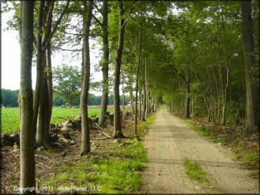
Pachaug State Forest Trail Photo
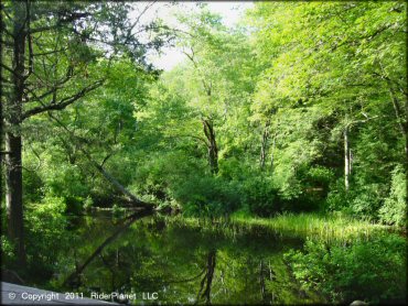
Pachaug State Forest Trail Photo
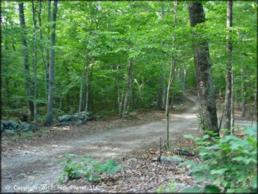
This is one of the motorcycle trails.
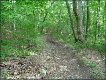
Pachaug State Forest Trail Photo
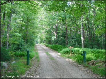
Motorcycles are permitted on all of the dirt roads throughout the forest but they must be street legal.
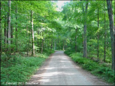
Pachaug State Forest Trail Photo
This is a good place to bring the dual sport for a late spring or fall ride.
Pachaug State Forest Trail Photo

An informational kiosk at Doug's Place Picnic Area.
Pachaug State Forest Trail Photo
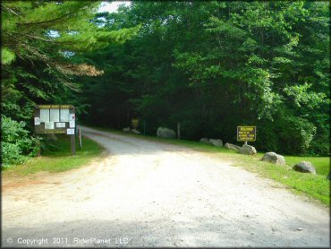
This is the main entrance to Mt. Misery Campground, which has 22 primitive sites.
Pachaug State Forest Trail Photo
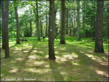
Doug's Picnic Area has some nice shady spots with BBQ grills. This area is for day use only.
Pachaug State Forest Trail Photo
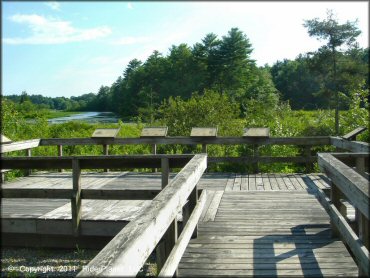
This observation deck offers some nice views of Beachdale Pond.
Pachaug State Forest Trail Photo
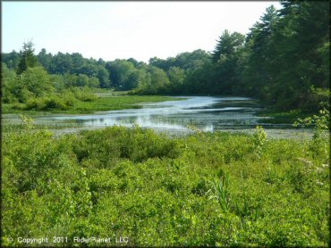
Beachdale Pond is stocked with various trout and bass fish.
Pachaug State Forest Trail Photo
Trails are that open to motorcycles are labled with red arrows on the trees.
Pachaug State Forest Trail Photo
RIDER COMMENTS & REVIEWS