 |
      |
| Home > Florida > Tates Hell OHV |
Tates Hell OHV Trail System
Saturday, May 10, 2025
| Other Names | Tate's Hell, Pine Branch Staging Area, County Line OHV Campground, Pine Log Creek, Womack Creek |
| Last Known Status | Open |
This large area offers about 150 miles of dirt roads that wind through a dense swamp and pine flatwoods forest, with wildlife consisting of panthers, bald eagles, gopher tortoise and black bear. The trails are primarily old forest service roads that are flat and hard packed with a few sandy sections. For those looking for more challenging terrain check out nearby Apalachicola National Forest.
The trail system has a nice staging area with spacious parking, picnic tables, restrooms and a self pay kiosk. A primitive campground with direct trail access can be found a couple miles north off of Hwy 67. There is a small fee charged to camp here and reservations are recomended, which can be made online.
The forest gets its name from a local legend about a farmer named Cebe Tate who back in 1875 got lost for about a week while searching for the panther that was killing his livestock. After emerging from the swamp near the town of Carrabelle he came across some locals and just before dying said "My name is Cebe Tate, and I just came from Hell!"
REGULATIONS
| Permit Required | Yes | FL OHV Permit |
| Dates Open | Year-Round | |
| Other ATV Stickers Accepted | Unknown | |
| Spark Arrestor | Yes | A spark arresting exhaust silencer or end cap is required for all vehicles. |
| Noise Limit | Yes (96 dB) | |
| Whip Flags | Not Required | |
| Maximum Vehicle Width | Yes (64 inches) | has entrance gate or posts |
 Motorcycles & Dirt Bikes Motorcycles & Dirt Bikes | Permitted | |
 ATVs ATVs | Permitted | |
 UTV & SXS UTV & SXS | Permitted | (maximum width 64 inches) |
 SUVs & Jeeps (registered) SUVs & Jeeps (registered) | Prohibited | |
| Dune Buggy & Swamp Buggy 4x4 (unregistered) | Prohibited | |
| 2 Stroke Engines | No Restriction | |
| MX Helmet Required | Youth Only | required for persons under 16 by state law (RiderPlanet strongly recommends helmets for all riders.) |
 Camping Camping | Some Areas | (camp in developed sites only) |
 Campfires Campfires | Some Areas | (permitted in developed campsites only) |
| Night Riding | No | trails open 8am to one half hour before sunset |
| Trail Blazing | Prohibited | keep on designated trails |
| Alcohol | Prohibited | |
| Rule Enforcement | ||
| Comment | Florida law requires OHVs to be titled when operating on public land. Proof of ownership is required when operating machines. | |
TYPE OF AREA
| Area | Motorized Trails |
| Land | State Forest |
FEES & PASSES
| Parking | (None) |
| Entry | (None) |
| Riding | Yes ($15.00 per rider) Three Day Pass - $15/rider |
| Camping | Yes Tent: $10.00 RV: $10.00 Addtl. Vehicle: $0.00 County Line OHV Campground Fee |
RATINGS
| Our Rating |  Good Good |
| Recommended Stay | Full Day |
| Comments | (Scroll Down For Rider Reviews & Comments) |
DRIVING DIRECTIONS
| Nearest City | Carabelle, FL | ||
| From: Tallahassee, FL
1) Take US-319 south about 50 miles 2) Turn right (north) on CR-67, continue 6.9 miles 3) Turn left (west) on Gully Branch Road, continue about .5 miles to staging area. |

OFFICIAL CONTACTS
| Contact Info | Tates Hell State Forest 290 Airport Road Carrabelle, FL 32322 (850) 697-0010 marti.miller@freshfromflorida.com www.fdacs.gov |
Tates Hell OHV Trail Photo
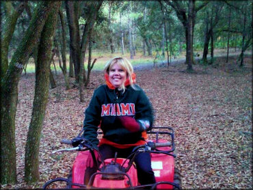
Photo Submitted 10/31/2016 (Thanks!)
ADD PHOTOS
TERRAIN
| Approx Size | 202,437 acres (316 sq mi) | |
| Miles Of Trail | 150 | |
| Climate Type | Swamp | |
| Elevation | 10 to 40 ft. | |
| Trail Maintenance | Marked, Not Rated, Lightly Maintained | |
| Loose Dirt |  None None | |
| Hard Pack |  Mostly Mostly | |
| Sand |  Little Little | |
| Mud | None | |
| Dust | Little | |
| Rocks | None | |
| Trees |  Many Many | |
| Steep Hills | None | |
| Water Crossings | None | |
| Small Jumps | None | |
| Large Jumps | None | |
| Berms | None | |
| Sand/Gravel Pits | None | |
| Single Track | None | |
| Roads |  All All | |
| Shade |  Some Some | |
| Hazards |  Few Few | (hazards assumed marked but use caution) |
 Novice Novice | Some | |
 Amateur Amateur | Mostly | |
 Expert Expert | Little |


KEY SERVICES
 Gasoline Gasoline | 5-20 Miles (S) | Chevron (850) 697-2190 |
| Diesel | 5-20 Miles (S) | Chevron (850) 697-2190 |
 Water Water | 1-5 Miles (SE) | Ho Hum RV Park (850) 697-3926 |
 RV Hookup RV Hookup | 1-5 Miles (SE) | Ho Hum RV Park (850) 697-3926 |
 RV Disposal RV Disposal | 1-5 Miles (SE) | Ho Hum RV Park (850) 697-3926 |
| Campground | 5-20 Miles (E) | Ochlockonee River State Park (850) 962-2771 |
 Conv Store Conv Store | 5-20 Miles (SW) | Carrabelle IGA (850) 697-2710 |
RIDER COMMENTS & REVIEWS