 |
      |
| Home > Georgia > Whissenhunt |
Whissenhunt OHV Trail System
Monday, September 8, 2025
| Other Names | Chattahoochee-Oconee National Forests, Blue Ridge Ranger District, Wissenhunt Mountain, Sally Free Ridge, Campbell Mountain, Little Cane Creek, Clay Creek, Whissenhunt ORV Area |
| Last Known Status | Open |
This trail system has around 11 miles of well marked trails with scenic forest and mountain views. The trails are mostly hard packed and covered with occasional loose rock and gravel. The area is best explored after a light rain since the trails can get pretty dusty during dry weather.
Those who are driving RVs or long trailers should be aware that the main entrance is narrow with only enough room for one vehicle at a time. Parking and services are limited at the staging area.
REGULATIONS
| Permit Required | Yes | OHV Trail Permit |
| Dates Open | Mid March - December 31 | |
| Other ATV Stickers Accepted | Unknown | |
| Spark Arrestor | Yes | A spark arresting exhaust silencer or end cap is required for all vehicles. |
| Noise Limit | Yes | |
| Whip Flags | Not Required | |
| Maximum Vehicle Width | Yes (48 inches) | has entrance gate or posts |
 Motorcycles & Dirt Bikes Motorcycles & Dirt Bikes | Permitted | |
 Four Wheelers Four Wheelers | Permitted | (maximum width 48 inches) |
 UTV & SXS UTV & SXS | Prohibited | |
 SUVs & Jeeps (registered) SUVs & Jeeps (registered) | Prohibited | |
| Dune Buggy & Sand Rail 4x4 (unregistered) | Prohibited | |
| 2 Stroke Engines | No Restriction | |
 Camping Camping | Prohibited | |
 Campfires Campfires | Prohibited | |
| Night Riding | No | riding hours sunrise to sunset |
| Trail Blazing | Prohibited | keep on the trail |
| Rule Enforcement |
TYPE OF AREA
| Area | Motorized Trails |
| Land | National Forest |
FEES & PASSES
| Parking | (None) |
| Entry | (None) |
| Riding | Yes ($5.00 per rider) |
| Camping | (None) |
| Comment | Annual Pass - $50/rider. Pass can be purchased at any Chattahoochee - Oconee National Forest ranger station. |
RATINGS
| Our Rating |  |
| Recommended Stay | Full Day |
| Comments | (Scroll Down For Rider Reviews & Comments) |
DRIVING DIRECTIONS
| Nearest City | Dahlonega, GA | ||
| Address | Camp Wahsega Road, Dahlonega, GA 30533 | ||
| From: Dahlonega, GA
1) Take US-19 North (SR-60) 2.2 miles 2) Turn left onto Camp Washega Road, continue 4.1 miles 3) Staging area entrance is on the left (south). |


OFFICIAL CONTACTS
| Contact Info | Chattahoochee - Oconee National Forests - Blue Ridge District 1881 Highway 515, P.O. Box 9 Blairsville, GA 30512 (706) 745-6928 mailroom_r8_chattahoochee@fs.fed.us www.fs.usda.gov |
| Contact Info | Clay Creek Falls Grocery Store 2261 Oak Grove Road Dahlonega, GA 30533 (706) 482-0515 |
| Comment | Sells Annual OHV Pass. |
Whissenhunt Trail Photo
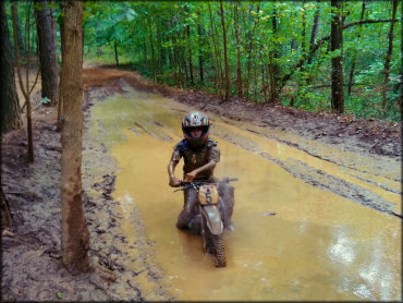
Photo Submitted 5/15/2020 (Thanks!)
Whissenhunt Trail Photo

Photo Submitted 8/29/2016 (Thanks!)
ADD PHOTOS
TERRAIN
| Approx Size | 700 acres (1 sq mi) | |
| Miles Of Trail | 11 | |
| Climate Type | Forest | |
| Elevation | 1400 to 2000 ft. | |
| Trail Maintenance | Marked, Not Rated, Lightly Maintained | |
| Loose Dirt |  Little Little | |
| Hard Pack |  Mostly Mostly | |
| Sand |  None None | |
| Mud | Little | |
| Dust | Little | |
| Rocks | Little | |
| Trees |  All All | |
| Steep Hills |  Few Few | |
| Water Crossings | None | |
| Small Jumps | None | |
| Large Jumps | None | |
| Berms |  Some Some | |
| Sand/Gravel Pits | None | |
| Single Track | None | |
| Roads | None | |
| Shade |  Many Many | |
| Hazards | Few | (hazards assumed marked but use caution) |
 Novice Novice | Little | |
 Amateur Amateur | Mostly | |
 Expert Expert | Some |
GPS POINTS


KEY SERVICES
 Gasoline Gasoline | 5-20 Miles (SE) | Chevron (706) 867-0020 |
| Diesel | 5-20 Miles (SE) | Chevron (706) 867-0020 |
 Water Water | Dahlonega, GA | |
 RV Hookup RV Hookup | 20-30 Miles (SW) | Etowah River Campground (706) 864-9035 |
 RV Disposal RV Disposal | 20-30 Miles (SW) | Etowah River Campground (706) 864-9035 |
| Campground | 20-30 Miles (SW) | Etowah River Campground (706) 864-9035 |
 Conv Store Conv Store | 5-20 Miles (SE) | Chevron (706) 867-0020 |
RIDER COMMENTS & REVIEWS