 |
      |
| Home > New Hampshire > Hopkinton-Everett |
Hopkinton-Everett Trail System
Friday, May 23, 2025
| Other Names | Stark Pond, Stark Brook, Bob Thomas Trail, River Loop, Bassett Mill Loop, Sugar Hill Loop |
| Last Known Status | Open |
This popular ATV area offers around 26 miles of narrow woods trails and designated single track motorcycle loops. The trails are regularly maintained and have moderate elevation changes with some pretty cool bridge crossings and pleasant views of Everett Lake.
The main staging is actually two fenced off adjacent dirt lots but there is plenty of space to accommodate large trailers. Each dirt lot has an informational kiosk and a loading ramp. There is no fee to ride but machines must display a current New Hampshire OHRV Sticker.
The trails are open daily during daylight hours but may close on short notice due to flood control operations so call first before heading out.
REGULATIONS
| Permit Required | Yes | NH OHRV Sticker |
| Dates Open | Late May through late November (weather and reservoir flood management operations permitting) | |
| Other ATV Stickers Accepted | No | NH OHRV or Temporary Nonresident Registration required. |
| Spark Arrestor | Yes | A spark arresting exhaust silencer or end cap is required for all vehicles. |
| Noise Limit | Yes (96 dB) | |
| Whip Flags | Not Required | |
| Maximum Vehicle Width | Yes (50 inches) | has entrance gate and narrow terrain vehicles under 1,000lbs dry weight and 50 inches wide permitted |
 Motorcycles & Dirt Bikes Motorcycles & Dirt Bikes | Permitted | |
 ATVs ATVs | Permitted | (maximum width 50 inches) |
 UTV & SXS UTV & SXS | Permitted | (maximum width 50 inches) |
 SUVs & Jeeps (registered) SUVs & Jeeps (registered) | Prohibited | |
| Dune Buggy & Sand Rail 4x4 (unregistered) | Prohibited | |
| 2 Stroke Engines | No Restriction | |
| MX Helmet Required | Yes | |
 Camping Camping | Prohibited | |
 Campfires Campfires | Prohibited | small gas grills are permitted in the parking lot |
| Night Riding | No | |
| Trail Blazing | Prohibited | stay on the trail |
| Rule Enforcement | ||
| Comment | When trails are snow covered, the road that goes through the area (Old 77) is closed to all use except for snowmobiles. For current road conditions contact the US Army Corps of Engineers. | |
TERRAIN
| Approx Size | 10,000 acres (16 sq mi) | |
| Miles Of Trail | 26 | |
| Climate Type | Forest | |
| Elevation | 380 to 420 ft. | |
| Trail Maintenance | Marked, Not Rated, Heavily Maintained | trails are marked with directional arrow signs |
| Loose Dirt |  Little Little | |
| Hard Pack |  Mostly Mostly | |
| Sand | Little | |
| Mud |  Some Some | |
| Dust | Little | |
| Rocks | Little | |
| Trees |  All All | |
| Steep Hills |  Few Few | |
| Water Crossings |  Many Many | trail system has over 100 bridge crossings |
| Small Jumps |  None None | |
| Large Jumps | None | |
| Berms | Many | |
| Sand/Gravel Pits | None | |
| Single Track | Many | single track trails have a maximum width of 36 inches |
| Roads | None | |
| Intersections | Few | |
| Rider Traffic | Some | |
| Shade | Many | |
| Hazards | Few | (hazards assumed marked but use caution) |
 Novice Novice | Some | |
 Amateur Amateur | Mostly | |
 Expert Expert | Little | |
| Comment | most trail are one-way but some sections are open to two-way traffic | |
TYPE OF AREA
| Area | Motorized Trails |
| Land | Army Corps of Engineers |


KEY SERVICES
 Gasoline Gasoline | 1-5 Miles (NE) | Trailside Gas (603) 774-8556 |
| Diesel | 1-5 Miles (NE) | Trailside Gas (603) 774-8556 |
 Water Water | 1-5 Miles (SW) | Cold Springs Campground (603) 529-2528 |
 RV Hookup RV Hookup | 1-5 Miles (SW) | Cold Springs Campground (603) 529-2528 |
 RV Disposal RV Disposal | 1-5 Miles (SW) | Cold Springs Campground (603) 529-2528 |
| Campground | 1-5 Miles (SW) | Cold Springs Campground (603) 529-2528 |
 Conv Store Conv Store | 1-5 Miles (NE) | Trailside Gas (603) 774-8556 |
FEES & PASSES
| Parking | (None) |
| Entry | (None) |
| Riding | (None) |
| Camping | (None) |
RATINGS
| Our Rating |  Good Good |
| Recommended Stay | Full Day |
| Comments | (Scroll Down For Rider Reviews & Comments) |
DRIVING DIRECTIONS
| Nearest City | Concord, NH | ||
| Address | Ray Road, Dunbarton, NH 03046 | ||
| From: Concord, NH
1) Take SR-13 West about 6 miles 2) Turn left (south) onto Ray Road, continue about 1 mile toward staging area. |


OFFICIAL CONTACTS
| Contact Info | Matthew Hackett (Park Ranger) US Army Corps of Engineers - Hopkinton-everett Lake 2097 Maple Street Contoocook, NH 03229 (603) 746-3601 matthew.r.hackett@usace.army.mil www.nae.usace.army.mil |
| Comment | Ext 321 |
| Contact Info | New Hampshire Fish And Game - OHRV Department 11 Hazen Drive Concord, NH 03301 (603) 271-4300 (603) 271-3129 licenseandregistration@wildlife.nh.gov wildlife.state.nh.us |
| Contact Info | Merrimack Valley Trail Riders 16 Winding Pond Road Londonderry, NH 03053 ta@mvtr.org squeracing@aol.com |
Hopkinton-Everett Trail Photo
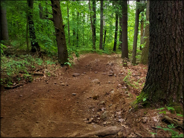
Most of the trails are fairly smooth with occasional loose chunk rock and exposed tree roots.
Hopkinton-Everett Trail Photo
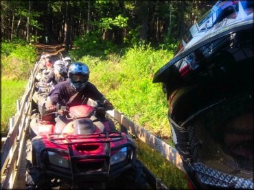
The trail system has many wooden bridges that cross over shallow creeks. The bridges support ATVs and UTVs up to 50 inches wide.
Hopkinton-Everett Trail Photo
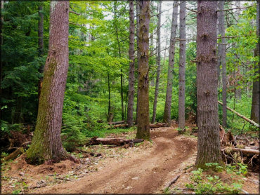
Most of the trails are twisty with light elevation changes.
Hopkinton-Everett Trail Photo

The forest is full of various wildflowers that can be seen from the ATV trails.
Hopkinton-Everett Trail Photo
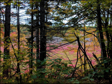
Fall is one of the best times to visit this area.
RIDER COMMENTS & REVIEWS