 |
      |
| Home > North Carolina > Wayehutta |
Wayehutta ATV System
Tuesday, March 31, 2026
| Other Names | Roy A. Taylor ATV Trail System, Jack Rabbit Hill, Nantahala National Forest |
| Last Known Status | Open |
This part of the Nantahala National Forest has about 28 miles of marked trail loops. Numerous bridge crossings, dense forest vegetation and a scenic waterfall trademark this popular trail system. Trails range from easy to difficult with some sections being very rocky and challenging.
The main staging area offers level parking and has a nice day use area that consists of picnic tables and a large gazebo. Cell phone service is not available at the staging area but a signal can usually be picked up along most of the trails and mountain ridges.
Visitors should note that there is no longer an onsite self service pay station and passes must be purchased in advance by either visiting the Nantahala Ranger District, Caney Fork General Store or Top Cat Grocery.
REGULATIONS
| Permit Required | No | |
| Dates Open | April 1 - December 15 | |
| Other ATV Stickers Accepted | Unknown | |
| Spark Arrestor | Yes | A spark arresting exhaust silencer or end cap is required for all vehicles. |
| Noise Limit | Yes (99 dB) | |
| Whip Flags | Not Required | |
| Maximum Vehicle Width | Yes (62 inches) | bridge crossings have a width restriction of about 64" |
 Motorcycles & Dirt Bikes Motorcycles & Dirt Bikes | Permitted | |
 Four Wheelers Four Wheelers | Permitted | |
 UTV & SXS UTV & SXS | Permitted | (maximum width 62 inches) |
 SUVs & Jeeps (registered) SUVs & Jeeps (registered) | Prohibited | |
| Dune Buggy & Sand Rail 4x4 (unregistered) | Prohibited | |
| 2 Stroke Engines | No Restriction | |
| MX Helmet Required | Yes | |
 Camping Camping | Prohibited | |
 Campfires Campfires | ||
| Night Riding | No | |
| Trail Blazing | Prohibited | stay on designated trails |
| Alcohol | Prohibited | |
| Rule Enforcement | ||
| Comment | Children under 8 may not operate ATVs or motorcycles. Children under 12 may not operate any ATV 70cc or larger. Children under 16 may not operate any ATV 90cc or larger. Operators under 16 must be under the supervision of a person over 18. | |
TERRAIN
| Approx Size | 39,680 acres (62 sq mi) | |
| Miles Of Trail | 28 | |
| Climate Type | Forest | |
| Elevation | 3000 to 5000 ft. | |
| Trail Maintenance | Marked, Rated, Heavily Maintained | |
| Loose Dirt |  Mostly Mostly | |
| Hard Pack |  Little Little | |
| Sand |  None None | |
| Mud | Little | |
| Dust | Little | |
| Rocks |  Some Some | |
| Trees |  All All | |
| Steep Hills |  Few Few | |
| Water Crossings | None | |
| Small Jumps | None | |
| Large Jumps | None | |
| Berms | Some | |
| Sand/Gravel Pits | None | |
| Single Track | Some | |
| Roads | None | |
| Shade |  Many Many | |
| Hazards | Few | (hazards assumed marked but use caution) |
 Novice Novice | Some | |
 Amateur Amateur | Mostly | |
 Expert Expert | Some | |
| Comment | MedWest EMS (828) 456-7311 serves up to the parking lot with normal EMS service. Jackson County Rescue Squad (828) 586-8719 will respond anywhere in the park with multiple UTVs and medical bed. | |
TYPE OF AREA
| Area | Motorized Trails |
| Land | National Forest |
GPS POINTS


KEY SERVICES
 Gasoline Gasoline | 5-20 Miles (S) | Moonshine Mini Mart (828) 293-5015 |
| Diesel | 5-20 Miles (S) | Moonshine Mini Mart (828) 293-5015 |
 Water Water | On Site | |
 RV Hookup RV Hookup | 5-20 Miles (N) | Moonshine Creek Campground (828) 586-6666 |
 RV Disposal RV Disposal | 5-20 Miles (N) | Moonshine Creek Campground (828) 586-6666 |
| Campground | Cullowhee, NC | |
 Conv Store Conv Store | 5-20 Miles (S) | Moonshine Mini Mart (828) 293-5015 |
FEES & PASSES
| Parking | (None) |
| Entry | (None) |
| Riding | Yes ($5.00 per OHV) |
| Camping | (None) |
RATINGS
| Our Rating |  |
| Recommended Stay | Full Day |
| Comments | (Scroll Down For Rider Reviews & Comments) |
DRIVING DIRECTIONS
| Nearest City | Cullowhee, NC | ||
| Address | Wayehutta Road, Cullowhee, NC 28723 | ||
| From: Hazelwood, NC
1) Take US-23 (US-74) South to Exit 85 2) Merge onto US-23 South, continue 1.4 miles 3) Turn left (east) onto Main Street/SR-107, continue about 3 miles 4) Turn left onto Old Cullowhee Road/SR-1002, continue 3.6 miles 5) Turn left onto Wayehutta Road, continue about 4 miles toward staging area. |


OFFICIAL CONTACTS
| Contact Info | Nantahala National Forest - Nantahala Ranger District 90 Sloan Road Franklin, NC 28734 (828) 524-6441 mailroom_r8_north_carolina@fs.fed.us www.fs.usda.gov |
| Contact Info | Smokey Mountain ORV Club (828) 586-5679 |
| Contact Info | Caney Fork General Store 7032 Highway 107 Cullowhee, NC 28723 (828) 293-7032 mickluker@aol.com |
| Comment | sells trail passes |
| Contact Info | Top Cat Grocery 3275 US 441 South Sylva, NC 28779 (828) 586-0847 info@lewisoilcompany.com |
| Comment | sells trail passes |
Wayehutta Trail Photo
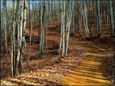
Photo Submitted 11/29/2012 (Thanks!)
Wayehutta Trail Photo
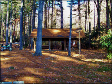
Photo Submitted 12/5/2012 (Thanks!)
Wayehutta Trail Photo
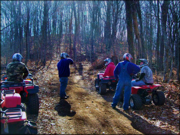
Photo Submitted 12/5/2012 (Thanks!)
Wayehutta Trail Photo
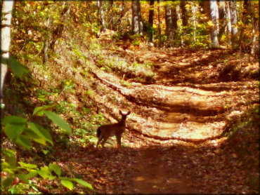
Photo Submitted 12/5/2012 (Thanks!)
Wayehutta Trail Photo
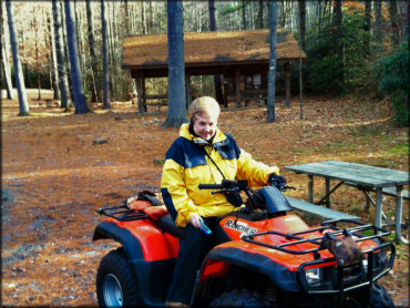
Photo Submitted 11/29/2012 (Thanks!)
RIDER COMMENTS & REVIEWS