 |
      |
| Home > North Carolina > Uwharrie OHV |
Uwharrie OHV Trail System
Tuesday, March 31, 2026
| Other Names | Uwharrie National Forest, Shingle Trap Mountain, Dutch Jones Creek, Gold Mine Branch, Moccasin Creek, Badin Lake OHV Trails, Art Lilley Campground, Art Lilly Campground |
| Last Known Status | Open |
This place is very popular for Jeeps because the rugged trails consist of steep and chunky climbs, deep ruts, seasonal mud pits and a few shallow stream crossings. The 20 mile trail system is primarily geared for 4x4s and four wheelers but all vehicle types including dirt bikes are permitted.
Free primitive camping with direct trail access can be found at Art Lilley Campground. The campground is graded with loose gravel and sites are available on a first come, first serve basis. Amenities include a vault toilet, unloading ramp and garbage cans but no running water. There are several full service campgrounds nearby including Arrowhead Campground and Badin Lake Campground but they do not provide direct off-road access so unless street legal, machines need to be hauled to and from the staging areas.
There are several staging areas to choose from but the trail that starts from Cotton Place Staging Area is rated as extremely difficult and should only be attempted by experienced riders.
Visitors should note that an OHV Trail Pass is required and must be purchased prior to arrival since there is no on-site self service pay station. Passes can be purchased at nearby vendors (see map for locations) or by visiting the Uwharrie National Forest District Office.
REGULATIONS
| Permit Required | Yes | OHV Trail Pass |
| Dates Open | April 1 - December 15 | |
| Other ATV Stickers Accepted | Unknown | |
| Spark Arrestor | Yes | A spark arresting exhaust silencer or end cap is required for all vehicles. |
| Noise Limit | Yes (99 dB) | |
| Whip Flags | Not Required | |
| Maximum Vehicle Width | No Restriction | |
 Motorcycles & Dirt Bikes Motorcycles & Dirt Bikes | Permitted | |
 Four Wheelers Four Wheelers | Permitted | |
 UTV & SXS UTV & SXS | Permitted | |
 SUVs & Jeeps (registered) SUVs & Jeeps (registered) | Permitted | |
| Dune Buggy & Sand Rail 4x4 (unregistered) | Permitted | |
| 2 Stroke Engines | No Restriction | |
| MX Helmet Required | Yes | required for dirt bike and ATV riders, not required for UTVs |
 Camping Camping | Some Areas | (camp in developed sites only) |
 Campfires Campfires | Some Areas | (permitted in developed campsites only) |
| Night Riding | Yes | working headlights and brake lights required |
| Trail Blazing | Prohibited | keep on the trail |
| Rule Enforcement | ||
| Comment | Children under age 8 are not permitted to operate ATVs or motorcycles. Double riding is strictly prohibited unless the ATV is manufactured to hold two riders. | |
TERRAIN
| Approx Size | 6,400 acres (10 sq mi) | |
| Miles Of Trail | 20 | |
| Climate Type | Forest | |
| Elevation | 250 to 800 ft. | |
| Trail Maintenance | Marked, Not Rated, Lightly Maintained | |
| Loose Dirt |  Some Some | |
| Hard Pack | Some | |
| Sand |  None None | |
| Mud | Some | |
| Dust |  Mostly Mostly | trails and gravel access roads are very dusty during dry weather |
| Rocks | Some | |
| Trees |  Many Many | |
| Steep Hills | Some | |
| Water Crossings | Some | |
| Small Jumps | None | |
| Large Jumps | None | |
| Berms | None | |
| Sand/Gravel Pits | None | |
| Single Track | None | |
| Roads | Some | |
| Shade | Many | |
| Hazards |  Few Few | (hazards assumed marked but use caution) |
 Novice Novice | Some | |
 Amateur Amateur | Mostly | |
 Expert Expert | Some |
TYPE OF AREA
| Area | Motorized Trails |
| Land | National Forest |
GPS POINTS


KEY SERVICES
 Gasoline Gasoline | 1-5 Miles (N) | Eldorado Outpost (910) 572-3474 |
| Diesel | 1-5 Miles (N) | Eldorado Outpost (910) 572-3474 |
 Water Water | 1-5 Miles (N) | Uwharrie Hunt Campground (910) 576-6391 |
 RV Hookup RV Hookup | 1-5 Miles (NW) | Arrowhead Campground (910) 576-6391 |
 RV Disposal RV Disposal | 1-5 Miles (NW) | Arrowhead Campground (910) 576-6391 |
| Campground | 1-5 Miles (N) | Uwharrie Hunt Campground (910) 576-6391 |
 Conv Store Conv Store | 1-5 Miles (N) | Eldorado Outpost (910) 572-3474 |
FEES & PASSES
| Parking | (None) |
| Entry | Yes ($5.00 per vehicle) Daily OHV Pass - $5; Season Pass - $30 |
| Riding | (None) |
| Camping | (None) |
| Comment | No fee charged for camping at Art Lilley Campground but a valid trail pass is required. |
RATINGS
| Our Rating |  |
| Recommended Stay | Full Day |
| Comments | (Scroll Down For Rider Reviews & Comments) |
DRIVING DIRECTIONS
| Nearest City | Uwharrie, NC | ||
| Address | Moccasin Creek Road, Troy, NC 27371 | ||
| From: Lexington, NC
1) Take US-64 East to the junction of SR-109, about 10 miles 2) Turn right (south) on SR-109, continue about 25 miles 3) Veer right on SR-1153/Reservation Road, continue .4 miles 4) Turn right (west) onto Moccasin Creek Road, continue 1.5 miles 5) Turn left (south) onto Dutch John Road, continue about .5 miles toward staging area. For the Wolf Den Staging Area: 6) Continue west past the Dutch John Road about 2 miles 7) Staging area is on the left (east). For the Art Lilly Campground/Falls Dam Staging Area: 8) Continue west past the Wolf Den Staging Area about .1 miles 9) Follow signage for the campground. |


OFFICIAL CONTACTS
| Contact Info | Uwharrie National Forest - Uwharrie Ranger District 789 NC Hwy. 24/27 East Troy, NC 27371-9332 (910) 576-6391 sm.fs.ncnfs@usda.gov www.fs.usda.gov |
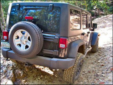
Uwharrie OHV Trail Photo
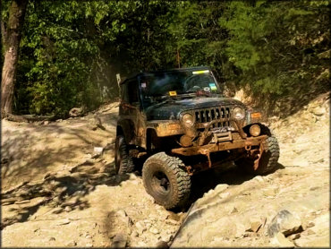
This is one of the premier off-road trail systems in the country due to the rugged and steep terrain.
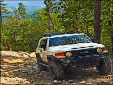
Uwharrie OHV Trail Photo
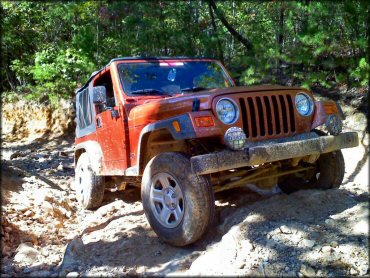
The trails here are primarily 4x4 roads that are extremely rocky. Jeeps will have a blast here.
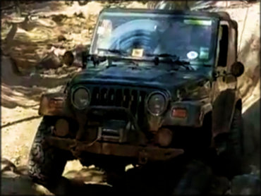
Uwharrie OHV Trail Photo
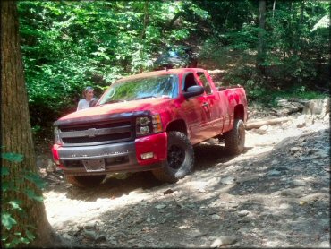
The trails are wide enough even for large stock pickup trucks.
Uwharrie OHV Trail Photo
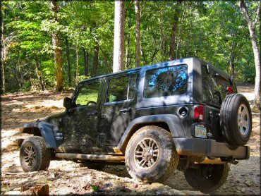
There are some moderate 4x4 trails that are easy enough for beginners but with just enough obstacles to keep the ride interesting.
Uwharrie OHV Trail Photo
A section of one of the easier 4x4 trails.
Uwharrie OHV Trail Photo
Most of the terrain is hard packed with loose chunk rock. This is the perfect place to bring an off-road 4x4 truck or Jeep.
Uwharrie OHV Trail Photo
Some of the Uwharrie 4x4 trails are extremely rocky and require careful tire placement and slow navigation.
RIDER COMMENTS & REVIEWS