 |
      |
| Home > Ohio > Pike State Forest |
Pike State Forest
Sunday, November 30, 2025
| Other Names | Pike State Forest ORV Trail |
| Last Known Status | Closed For Season |
This state forest has about 20 miles of ATV trails and a small novice play area. The trails form long loops and mostly smooth but there are some that are more challenging with steep and rough climbs. The area has some moderate elevation changes with nice scenic views.
The staging area offers plenty of room for large trailers but is open for day use only. Camping can be found at nearby Pike Lake State Park.
This trail system is open seasonally to motorized use from April 1 through November 30 each year.
REGULATIONS
| Permit Required | Yes | Ohio APV Tag |
| Dates Open | April 1 - November 30 | |
| Other ATV Stickers Accepted | Unknown | |
| Spark Arrestor | Yes | A spark arresting exhaust silencer or end cap is required for all vehicles. |
| Noise Limit | Yes | |
| Whip Flags | Not Required | |
| Maximum Vehicle Width | Yes (62 inches) | has entrance gate or posts |
 Motorcycles & Dirt Bikes Motorcycles & Dirt Bikes | Permitted | |
 ATVs ATVs | Permitted | |
 UTV & SXS UTV & SXS | Permitted | (maximum width 62 inches) |
 SUVs & Jeeps (registered) SUVs & Jeeps (registered) | Prohibited | |
| Dune Buggy & Sand Rail 4x4 (unregistered) | Prohibited | |
| 2 Stroke Engines | No Restriction | |
| MX Helmet Required | Yes | |
 Camping Camping | Prohibited | |
 Campfires Campfires | Some Areas | (permitted in developed campsites only) |
| Night Riding | No | riding is permitted from sunrise to sunset |
| Trail Blazing | Prohibited | no trailblazing |
| Alcohol | Prohibited | |
| Rule Enforcement |
Advertisement
TERRAIN
| Approx Size | 12,531 acres (20 sq mi) | |
| Miles Of Trail | 20 | |
| Climate Type | Forest | |
| Elevation | 750 to 1100 ft. | |
| Trail Maintenance | Marked, Not Rated, Lightly Maintained | |
| Loose Dirt |  Mostly Mostly | |
| Hard Pack |  Some Some | |
| Sand |  None None | |
| Mud | Some | |
| Dust |  Little Little | |
| Rocks | Little | |
| Trees |  All All | |
| Small Jumps | None | |
| Large Jumps | None | |
| Berms | None | |
| Sand/Gravel Pits | None | |
| Single Track | None | |
| Hazards |  Few Few | (hazards assumed marked but use caution) |
 Novice Novice | Some | |
 Amateur Amateur | Mostly | |
 Expert Expert | Little |
TYPE OF AREA
| Area | Motorized Trails |
| Land | State Forest |


KEY SERVICES
 Gasoline Gasoline | 5-20 Miles (E) | Tom's Drive Thru & Grocery (740) 493-3194 |
| Diesel | 5-20 Miles (E) | Tom's Drive Thru & Grocery (740) 493-3194 |
 Water Water | 5-20 Miles (NE) | Pike Lake State Park (740) 493-2212 or (866) 644-6727 |
 RV Hookup RV Hookup | 5-20 Miles (NE) | Pike Lake State Park (740) 493-2212 or (866) 644-6727 |
 RV Disposal RV Disposal | 5-20 Miles (NE) | Pike Lake State Park (740) 493-2212 or (866) 644-6727 |
| Campground | 5-20 Miles (NE) | Pike Lake State Park (740) 493-2212 or (866) 644-6727 |
 Conv Store Conv Store | 5-20 Miles (E) | Tom's Drive Thru & Grocery (740) 493-3194 |
FEES & PASSES
| Parking | (None) |
| Entry | (None) |
| Riding | (None) |
| Camping | (None) |
RATINGS
| Our Rating |  |
| Recommended Stay | Full Day |
| Comments | (Scroll Down For Rider Reviews & Comments) |
DRIVING DIRECTIONS
| Nearest City | Latham, OH | ||
| From: Chillicothe, OH
1) Take US-50 West toward the town of Bainbridge, about 21 miles 2) Turn left (south) on SR-41, continue about 14 miles 3) Turn left (east) on SR-124, continue about 3 miles. 4) Turn left on unmarked dirt road (look for a state forest building). |


OFFICIAL CONTACTS
| Contact Info | Pike State Forest Headquarters State Route 124 Mifflin Township, OH (740) 493-2441 forestry.comments@dnr.state.oh.us ohiodnr.gov |
| Contact Info | Ohio Bureau of Motor Vehicles 1970 West Broad Street Columbus, OH 43223 (614) 752-7800 webmaster@dps.state.oh.us www.bmv.ohio.gov |
| Comment | ATV and Motorcycle Registration Info |
Pike State Forest Trail Photo
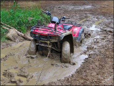
Photo Submitted 9/27/2012 (Thanks!)
Pike State Forest Trail Photo
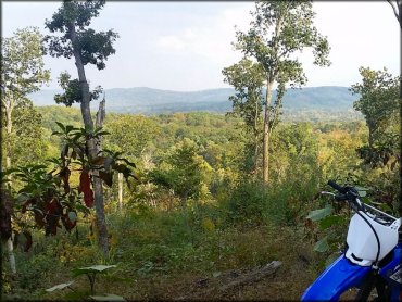
Photo Submitted 9/30/2014 (Thanks!)
Pike State Forest Trail Photo
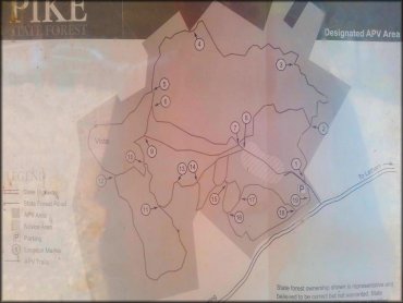
Photo Submitted 9/30/2014 (Thanks!)
Pike State Forest Trail Photo
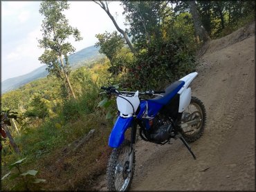
Photo Submitted 9/30/2014 (Thanks!)
RIDER COMMENTS & REVIEWS