 |
      |
| Home > Ohio > Powerline Park |
Powerline Park
Saturday, May 10, 2025
| Other Names | Powerline Park, Ohio |
| Last Known Status | Closed |
This offroad park was usually open for Memorial Day and Labor Day weekends with occasional special events in the spring and fall but is now closed with no plans to reopen. The park had about 20 miles of woods trails, deep water crossings, rock gardens, mud bogs and hill climbs and was open to all vehicle types.
REGULATIONS
| Permit Required | No | |
| Dates Open | Closed | |
| Spark Arrestor | Recommended | A spark arresting exhaust silencer or end cap is recommended. |
| Noise Limit | ||
| Whip Flags | Not Required | |
| Maximum Vehicle Width | No Restriction | |
 Motorcycles & Dirt Bikes Motorcycles & Dirt Bikes | Prohibited | |
 ATVs ATVs | Prohibited | |
 UTV & SXS UTV & SXS | Prohibited | |
 SUVs & Jeeps (registered) SUVs & Jeeps (registered) | Prohibited | |
| Dune Buggy & Sand Rail 4x4 (unregistered) | Prohibited | |
| 2 Stroke Engines | Prohibited | |
 Camping Camping | Some Areas | (camp in developed sites only) |
 Campfires Campfires | ||
| Night Riding | No | |
| Rule Enforcement | Strict | Dedicated Rangers/Officers Armed OfficersJeep/SUV Patrol |
Advertisement
TYPE OF AREA
| Area | Motorized Trails, MX Track |
| Land | Privately Owned / Commercial |
FEES & PASSES
| Parking | (None) |
| Entry | Yes ($50.00 per person) weekend fee includes camping |
| Riding | (None) |
| Camping | (None) |
| Comment | see website for current admission fees |
RATINGS
| Our Rating |  Good Good |
| Recommended Stay | Full Day |
| Comments | (Scroll Down For Rider Reviews & Comments) |
DRIVING DIRECTIONS
| Nearest City | St. Clairsville, OH | ||
| Address | 69560 Lee Road, St. Clairsville, OH 43950 | ||
| From: Columbus, OH
1) Take I-70 east to exit 213 2) Turn right (east) off the exit ramp onto SR-40, continue .1 mile 3) Turn left (north) on SR-56/Vineyard Road, continue about 2 miles 4) Turn right (west) on Lee Road, continue about 1 mile 5) Turn right (north-east) onto Pogue Road, proceed toward park entrance. |


OFFICIAL CONTACTS
Powerline Park OHV Area Photo
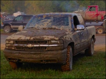
Photo Submitted 5/25/2014 (Thanks!)
ADD PHOTOS
TERRAIN
| Approx Size | 1,000 acres (2 sq mi) | |
| Miles Of Trail | 21 | |
| Climate Type | Forest | |
| Elevation | 1000 to 1250 ft. | |
| Trail Maintenance | Unknown | |
| Loose Dirt |  Some Some | |
| Hard Pack | Some | |
| Mud |  Mostly Mostly | |
| Dust |  Little Little | |
| Rocks | Some | |
| Trees |  All All | |
| Steep Hills | Some | |
| Water Crossings | Some | |
| Small Jumps | Some | |
| Large Jumps | Some | |
| Berms | Some | |
| Single Track | Some | |
| Hazards |  Few Few | (hazards assumed marked but use caution) |
 Novice Novice | Some | |
 Amateur Amateur | Mostly | |
 Expert Expert | Some |
GPS POINTS


KEY SERVICES
 Gasoline Gasoline | 1-5 Miles (SW) | Sunoco (740) 695-1717 |
| Diesel | 1-5 Miles (SW) | Sunoco (740) 695-1717 |
 Water Water | On Site | hot showers available - $3/person |
 RV Hookup RV Hookup | 1-5 Miles (SW) | Barkcamp State Park Campground (740) 484-4064 |
 RV Disposal RV Disposal | 1-5 Miles (SW) | Barkcamp State Park (740) 484-4064 |
| Campground | On Site | |
 Conv Store Conv Store | 1-5 Miles (SW) | Sunoco (740) 695-1717 |
RIDER COMMENTS & REVIEWS