 |
      |
| Home > Ohio > Fast Traxx Motoplex |
Fast Traxx Motoplex
Friday, February 7, 2025
| Other Names | Hocking River |
| Last Known Status | Open |
This track is open seasonally April through October and offers open practice on Wednesdays. The main track is 1.47 miles long and consists of loamy river bottom soil and winds through the woods. There is also a grand prix track available which is about 3.5 miles long. Practice dates are weather permitting, so call before you haul.
REGULATIONS
| Permit Required | No | |
| Dates Open | Wednesday 10am-8pm | |
| Spark Arrestor | Recommended | A spark arresting exhaust silencer or end cap is recommended. |
| Noise Limit | ||
| Whip Flags | Not Required | |
| Maximum Vehicle Width | ||
 Motorcycles & Dirt Bikes Motorcycles & Dirt Bikes | Permitted | |
 ATVs ATVs | Permitted | |
 UTV & SXS UTV & SXS | Prohibited | |
 SUVs & Jeeps (registered) SUVs & Jeeps (registered) | Prohibited | |
| Dune Buggy & Sand Rail 4x4 (unregistered) | Prohibited | |
| 2 Stroke Engines | No Restriction | |
 Camping Camping | No Restriction | (camp anywhere) |
 Campfires Campfires | ||
| Night Riding | No | |
| Trail Blazing | Prohibited | |
| Rule Enforcement |
Advertisement
TYPE OF AREA
| Area | MX Track |
| Land | Privately Owned / Commercial |
MX TRACK 
| Features | Public |
| Max Engine Size | No Maximum |
| Min Engine Size | No Minimum |
FEES & PASSES
| Parking | (None) |
| Entry | (None) |
| Riding | Yes ($20.00 per rider) |
| Camping | (None) |
RATINGS
| Our Rating |  Good Good |
| Recommended Stay | Full Day |
| Comments | (Scroll Down For Rider Reviews & Comments) |
DRIVING DIRECTIONS
| Nearest City | Nelsonville, OH | ||
| Address | 5999 Warren Drive, Nelsonville, OH 45764 | ||
| From: Nelsonville, OH
1) Take US-33 south about 4 miles 2) Turn right (west) on CR-4, make immediate left 3) Follow signs to track. |


OFFICIAL CONTACTS
| Contact Info | Fast Traxx Motoplex 5999 Warren Drive Nelsonville, OH 45764 (740) 767-3740 shawnabickley@hotmail.com fasttraxxracing.com |
| Contact Info | Fast Traxx Motoplex - Raceday Phone Number (740) 707-7336 |
Fast Traxx Motoplex Track Photo
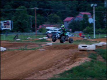
Photo Submitted 11/14/2016 (Thanks!)
ADD PHOTOS
TERRAIN
| Approx Size | 100 acres | |
| Climate Type | Urban/man-made | |
| Elevation | 650 to 700 ft. | |
| Loose Dirt |  Mostly Mostly | |
| Hard Pack |  Little Little | |
| Mud | Little | |
| Dust | Little | |
| Rocks |  None None | |
| Trees |  Some Some | |
| Steep Hills | None | |
| Water Crossings | None | |
| Small Jumps |  Many Many | |
| Large Jumps | Some | |
| Berms |  All All | |
| Sand/Gravel Pits | None | |
| Single Track | None | |
| Roads | None | |
| Shade | Some | |
| Hazards |  Few Few | (hazards assumed marked but use caution) |
 Novice Novice | Some | |
 Amateur Amateur | Mostly | |
 Expert Expert | Little |
GPS POINTS


KEY SERVICES
 Gasoline Gasoline | 5-20 Miles (N) | Speedway (740) 753-3410 |
| Diesel | 5-20 Miles (N) | Speedway (740) 753-3410 |
 Water Water | 5-20 Miles (N) | Crossroads Convenience Store (740) 753-2306 |
 RV Hookup RV Hookup | 5-20 Miles (W) | Happy Hills Campground (740) 385-6720 |
 RV Disposal RV Disposal | 5-20 Miles (W) | Happy Hills Campground (740) 385-6720 |
| Campground | 5-20 Miles (E) | Strouds Run State Park (740) 592-2302 |
 Conv Store Conv Store | 5-20 Miles (N) | Crossroads Convenience Store (740) 753-2306 |
RIDER COMMENTS & REVIEWS