 |
      |
| Home > Virginia > Peters Mill Run and Taskers Gap |
Peters Mill Run and Taskers Gap OHV Trails
Tuesday, March 31, 2026
| Other Names | Edinburg Gap, Mertins Rock, Short Mountain, Bowman Mountain, George Washington National Forest, Waonaze Peak, Powell Mountain, Opechee Peak, Golladays Gap, Walters Gap, Massanutten Mountain, Red Spring Gap, Little Fort Campground, Fort Valley ATV Park, Lee Ranger District |
| Last Known Status | Open |
This part of the George Washington National Forest offers two separate ATV trail systems that can be accessed from either the Edinburg or Taskers Gap staging areas. The trail that heads north is Peters Mill Run, a 12-mile, moderately rocky linear trail with a few side spurs and some seasonal creek crossings, while Taskers Gap to the south offers about a dozen marked loops with varying degrees of challenging terrain.
The Edinburg staging area has the most parking space and features a vault toilet plus a wide gravel loop, making it easier for trailers to turn around, plus direct access to both Peters Mill Run and the Taskers Gap trails. The Taskers Gap staging area has enough space for a few compact trucks but only provides access to the southern loops.
Camping with direct off-road trail access can be found at Little Fort campground, which has nine sites available on a first come, first serve basis. Each site comes with a picnic table, fire ring and tent pad. There is no fee charged to camp here but there are no pull through sites and space is limited to trailers about 20 feet long.
A permit is required to ride here which must be obtained prior to arrival since there is no self pay kiosk. Daily, three day and annual passes can be purchased local vendors (see map for locations), via mail or by visiting the Lee Ranger District Office.
REGULATIONS
| Permit Required | Yes | Taskers Gap/Peters Mill Run OHV Permit |
| Dates Open | First week of April through mid January | |
| Other ATV Stickers Accepted | Unknown | |
| Spark Arrestor | Yes | A spark arresting exhaust silencer or end cap is required for all vehicles. |
| Noise Limit | Yes (96 dB) | |
| Whip Flags | Not Required | |
| Maximum Vehicle Width | Yes (50 inches) | has entrance gate or posts Taskers Gap has 50" width restriction; Peters Mill has none |
 Motorcycles & Dirt Bikes Motorcycles & Dirt Bikes | Permitted | |
 ATVs ATVs | Permitted | (maximum width 50 inches) |
 UTV & SXS UTV & SXS | Permitted | (maximum width 50 inches) |
 SUVs & Jeeps (registered) SUVs & Jeeps (registered) | Some Areas | permitted on Peters Mill Run Trail |
| Dune Buggy & Sand Rail 4x4 (unregistered) | Some Areas | (maximum width 50 inches) permitted on Peters Mill Run Trail |
| 2 Stroke Engines | No Restriction | |
| MX Helmet Required | Yes | helmets required by state law |
 Camping Camping | Some Areas | (camp in developed sites only) |
 Campfires Campfires | Some Areas | (permitted in developed campsites only) |
| Night Riding | Unknown | |
| Trail Blazing | Prohibited | riders must stay on trail |
| Alcohol | Prohibited | |
| Rule Enforcement |
TERRAIN
| Approx Size | 22,400 acres (35 sq mi) | |
| Miles Of Trail | 40 | |
| Climate Type | Forest | |
| Elevation | 1500 to 2500 ft. | |
| Trail Maintenance | Marked, Not Rated, Lightly Maintained | |
| Loose Dirt |  Little Little | |
| Hard Pack |  Mostly Mostly | |
| Sand |  None None | |
| Mud |  Some Some | |
| Dust | Little | |
| Rocks | Mostly | |
| Trees |  All All | |
| Steep Hills |  Few Few | |
| Water Crossings | Few | |
| Small Jumps | None | |
| Large Jumps | None | |
| Berms | Few | |
| Sand/Gravel Pits | None | |
| Single Track | None | |
| Roads | Few | |
| Intersections | Few | |
| Rider Traffic | Some | |
| Shade |  Many Many | |
| Hazards | Few | (hazards assumed marked but use caution) |
 Novice Novice | Little | |
 Amateur Amateur | Mostly | |
 Expert Expert | Some |
TYPE OF AREA
| Area | Motorized Trails |
| Land | National Forest |
GPS POINTS


KEY SERVICES
 Gasoline Gasoline | 1-5 Miles (NW) | Shell (540) 984-3008 |
| Diesel | 1-5 Miles (NW) | Shell (540) 984-3008 |
 Water Water | 1-5 Miles (NW) | Creekside Campground (540) 984-4299 |
 RV Hookup RV Hookup | 1-5 Miles (NW) | Creekside Campground (540) 984-4299 |
 RV Disposal RV Disposal | 1-5 Miles (NW) | Creekside Campground (540) 984-4299 |
| Campground | On Site | Little Fort Campground |
 Conv Store Conv Store | 1-5 Miles (NW) | Shell (540) 984-3008 |
FEES & PASSES
| Parking | (None) |
| Entry | (None) |
| Riding | Yes ($5.00 per rider) Three Day Permit - $12, Annual Permit - $30 |
| Camping | (None) |
RATINGS
| Our Rating |  |
| Recommended Stay | Full Day |
| Comments | (Scroll Down For Rider Reviews & Comments) |
DRIVING DIRECTIONS
| Nearest City | Edinburg, VA | ||
| Address | Edinburg Gap Road, Edinburg, VA 22824 | ||
| From: Harrisonburg, VA
For Edinburg Staging Area: 1) Take I-81 North to Exit 279 2) Turn right (east) off the exit ramp onto Stoney Creek Blvd, continue .8 miles 3) Turn left (east) onto Main Street, continue .6 miles 4) Turn right (east) onto SR-65/SR-675/Edinburg Gap Road, continue 3.9 miles 5) Staging area is on the right (west). For Taskers Gap Staging Area: 6) Continue east on Edinburg Gap Road .8 miles 7) Turn right (west) onto dirt road, follow toward staging area. For Fort Valley Campground: 8) Continue east on Edinburg Gap Road 1.3 miles 9) Turn left (north) onto Fort Valley Road, continue 8.2 miles 10) Turn left (north-west) onto Woodstock Tower Road, continue 2.6 miles 11) Campground entrance is on the left. |


OFFICIAL CONTACTS
| Contact Info | George Washington National Forest - Lee Ranger District 95 Railroad Avenue Edinburg, VA 22824 (540) 984-4101 mailroom_r8_george_washington_jefferson@fs.fed.us www.fs.usda.gov |
| Contact Info | Appalachian Adventures 2093 East Main Street Luray, VA 22835 (540) 743-7311 vacation@appalachian-adventures.com appalachian-adventures.com |
| Comment | ATV Rentals |
Peters Mill Run and Taskers Gap Trail Photo
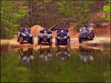
Just a couple hours west of Washington DC is this popular off-road trail system. The long loops and cool camping spots make this a popular place to bring the ATVs.
Peters Mill Run and Taskers Gap Trail Photo
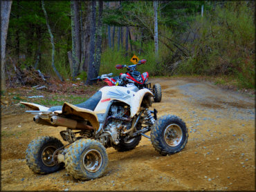
The ATV trails are signed and rated for difficulty, making it easy to get around.
Peters Mill Run and Taskers Gap Trail Photo
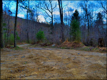
Most of the ATV trails are rugged and rocky but there are some sections that are smooth and hard packed.
Peters Mill Run and Taskers Gap Trail Photo
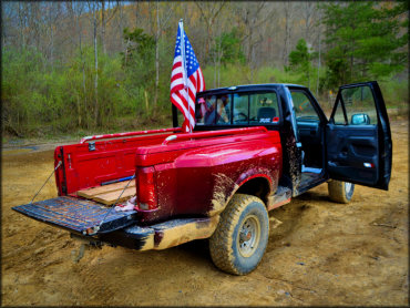
Trucks are permitted on the Peters Mill Run trail. The rest of the trail system is limited to dirt bikes, ATVs and UTVs 50 inches or less in width.
RIDER COMMENTS & REVIEWS