 |
      |
| Home > Minnesota |

 Alborn-Pengilly ATV Trail
Status: Open
Type: Trail (State Forest, County Land)
Location: Pengilly, MN
Difficulty:

This 39-mile trail follows an old abandoned railroad grade between the cities of Pengilly and Alborn. More...
Alger Grade OHM Trails Status: Closed For Season
Type: Trail (State Forest, Private)
Location: Alger, MN
Difficulty:

This trail system opened to the public in June 2022 and offers 14 miles of pure single track trails that are marked and rated. More...
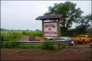 Appleton Area Recreation OHV Park
 Status: Open
Type: Combo (State Recreation, County Land)
Location: Appleton, MN
Difficulty:
Once the location of a former gravel mine, this offroad park is open daily year-round and has about 20 miles of marked trails, a motocross track, sand dunes and some play areas. More...
BCMX Adventure Park Status: Open
Type: Track (Privately Owned / Commercial)
Location: Cambridge, MN
Difficulty:
Formerly known as Cambridge MX, BCMX Adventure Park offers a main motocross track for big bikes and a separate track for beginners. More...
Berm Benders Raceway Status: Open
Type: Track (Privately Owned / Commercial)
Location: Brook Park, MN
Difficulty:
This long and fast track near Brook Park, Minnesota is open for practice on Tuesdays and Saturdays and also offers riding lessons during select dates. More...
 Big Aspen Recreation Area
 Status: Closed For Season
Type: Trail (National Forest)
Location: Virginia, MN
Difficulty:
This multiple use recreation area offers about 21 miles of mostly easy to moderate trails, which make it a decent place to take beginners. More...
Brooks International Raceway Status: Open (open during select weekends)
Type: Track (Privately Owned / Commercial)
Location: Brooks, MN
Difficulty:
This motocross park offers three motocross tracks that cater to all skill levels. More...
 CC Andrews State Forest
 Status: Open
Type: Trail (State Forest)
Location: Willow River, MN
Difficulty:
This area offers about 24 miles of marked and fairly easy trails that wind through a hardwood forest. More...
 Chengwatana State Forest OHV Trails
 Status: Open
Type: Trail (State Forest)
Location: Pine City, MN
Difficulty:
Situated on the west side of the Saint Croix River, this area offers about 15 miles of trails open to both ATVs and motorcycles. More...
Echo Valley Motocross Park Status: Open
Type: Track (Privately Owned / Commercial)
Location: Brookston, MN
Difficulty:
Situated on 40 acres, this park offers a one mile long natural terrain track. More...
(Page 1 of 5)
(Page 1 of 5)