 |
      |
| Home > Idaho |
 Sacajawea Motorsports Park
Status: Open
Type: Combo (County Land)
Location: Salmon, ID
Difficulty:

This motocross park offers a natural terrain track and a seperate peewee track plus a handful of trails. More...
Sagehen ATV Trail System Status: Open
Type: Trail (National Forest)
Location: Ola, ID
Difficulty:
This popular trail system has about 20 miles of ATV trails and a few miles of single track that is open to dirt bikes. More...
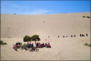 Saint Anthony Sand Dunes
 Status: Open
Type: Dune (BLM, SRMA)
Location: St. Anthony, ID
Difficulty:

Eastern Idaho is home to this 10,600 acre playground of white quartz dunes ranging from 10 feet to 300 feet high. More...
Sheep Driveway Trail Status: Open
Type: Trail (National Forest)
Location: Victor, ID
Difficulty:
This trail is roughly 17 miles long each way and is open to machines 50 inches or less in width. More...
Skyline MX Park And Events Center Status: Open
Type: Track (Privately Owned / Commercial)
Location: Owyhee, ID
Difficulty:
Formerly known as Pleasant Valley Raceway, Skyline MX has reopened after a period of closure. More...
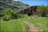 South Hills
Status: Closed For Season
Type: Trail (National Forest)
Location: Hansen, ID
Difficulty:
If you are coming to southern Idaho to ride, this spot should not be overlooked. More...
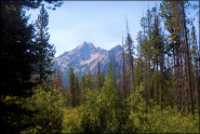 Stanley Lake
Status: Open
Type: Trail (National Forest)
Location: Stanley, ID
Difficulty:
Stanley Lake is smaller than nearby Redfish Lake, but packs in as much beauty with less traffic. More...
 Steamboat Creek
 Status: Open
Type: Trail (National Forest)
Location: Kingston, ID
Difficulty:
This part of the Coeur d'Alene National Forest offers over 25+ miles of designated ATV trails plus forest service roads to explore. More...
Stoddard Creek Status: Open
Type: Trail (National Forest)
Location: Spencer, ID
Difficulty:
This part of the Caribou-Targhee National Forest offers a pleasant campground with nearby access to ATV loops and miles of forest service roads.. More...