 |
      |
| Home > Arizona > Bartlett Lake |
Bartlett Lake Recreation Area
Saturday, December 23, 2023
| Other Names | Bartlett Reservoir, Horshoe Dam, Bootles Canyon, Indian Springs Wash, Verde River, Fr 42, Tonto National Forest, Bartlett Dam, Rattlesnake Recreation Site, South Cove Recreation Site |
| Last Known Status | Closed |
Bartlett Lake has one main but challenging 4x4 trail known as FR 42 that consists of sandy washes, steep hills and rocky sections but offers some fantastic views of Bartlette Lake and the Verde River.
The trail can be accessed either off Horsehoe Dam Road (north) or off Bartlett Dam Road (south). Both northern and southern trailheads are close to day use and primitive camping areas, making this an ideal choice for first time visitors.
Summer temperatures can get very hot (100+ degrees) so bring extra shade plus water. Keep an eye out for desert wildlife such as lizards and rattlesnakes. Most of the southern part and eastern part of Bartlett Lake is inaccessible, however the western side of the lake offers camping, picnic and day use facilities.
REGULATIONS
| Permit Required | Yes | AZGFD sticker required |
| Dates Open | Year-Round | |
| Other ATV Stickers Accepted | No | All non-residents must purchase an Arizona OHV decal. |
| Spark Arrestor | Yes | A spark arresting exhaust silencer or end cap is required for all vehicles. |
| Noise Limit | Yes (96 dB) | |
| Whip Flags | Not Required | |
| Maximum Vehicle Width | No Restriction | |
 Motorcycles & Dirt Bikes Motorcycles & Dirt Bikes | Prohibited | |
 ATVs ATVs | Prohibited | |
 UTV & SXS UTV & SXS | Prohibited | |
 SUVs & Jeeps (registered) SUVs & Jeeps (registered) | Prohibited | |
| Dune Buggy & Sand Rail 4x4 (unregistered) | Prohibited | |
| 2 Stroke Engines | Prohibited | |
| MX Helmet Required | Youth Only | required for persons under 18 by state law (RiderPlanet strongly recommends helmets for all riders.) |
 Camping Camping | Some Areas | (camp in developed sites only) |
 Campfires Campfires | Some Areas | (permitted in developed campsites only) |
| Night Riding | Unknown | |
| Trail Blazing | Prohibited | vehicles must stay on trail |
| Rule Enforcement | Few/Periodic |
TERRAIN
| Approx Size | 22,400 acres (35 sq mi) | |
| Miles Of Trail | 20 | |
| Climate Type | Desert | |
| Elevation | 1800 to 3900 ft. | |
| Trail Maintenance | Marked, Not Rated, Lightly Maintained | |
| Loose Dirt |  Some Some | |
| Hard Pack |  Little Little | |
| Sand |  Mostly Mostly | |
| Mud | Little | |
| Dust | Little | |
| Rocks | Mostly | |
| Trees |  Few Few | |
| Steep Hills | Some | |
| Sand/Gravel Pits |  None None | |
| Single Track | Few | |
| Roads | None | |
| Intersections | Few | |
| Rider Traffic | Some | |
| Shade | None | |
| Ranges/Gunfire | Few | |
| Hazards | Few | (hazards assumed marked but use caution) |
 Novice Novice | Little | |
 Amateur Amateur | Mostly | |
 Expert Expert | Some |
TYPE OF AREA
| Area | Motorized Trails |
| Land | National Forest |


KEY SERVICES
 Gasoline Gasoline | 5-20 Miles (W) | Shell (480) 488-3451 |
| Diesel | 5-20 Miles (W) | Shell (480) 488-3451 |
 Water Water | 5-20 Miles (W) | Carefree |
 RV Hookup RV Hookup | 20-30 Miles (W) | Cave Creek Recreation Area (623) 465-0431 |
 RV Disposal RV Disposal | 20-30 Miles (SE) | Bartlett Lake Marina (480) 221-0503 |
| Campground | On Site | |
 Conv Store Conv Store | 5-20 Miles (W) | Bashas (480) 488-1797 |
FEES & PASSES
| Parking | (None) |
| Entry | Yes ($8.00 per vehicle) Watercraft - $4/each (Yellow Cliffs Day Use Fee) |
| Riding | (None) |
| Camping | (None) |
RATINGS
| Pros | scenic views of Bartlett Lake and surrounding desert vegetation, on-site boat ramp and campgrounds |
| Cons | hot, dry |
| Our Rating |  Good Good |
| Recommended Stay | 1-2 Days Winter/Spring |
| Comments | (Scroll Down For Rider Reviews & Comments) |
DRIVING DIRECTIONS
| Nearest City | Rio Verde, AZ | ||
| Address | Bartlett Dam Road, Rio Verde, AZ 85263 | ||
| From: Carefree, AZ
For southern trailhead: 1) Follow N. Cave Creek Road East for about 6 miles 2) Turn right (east) on E. Bartlett Dam Road and continue for about 13 miles 3) After you pass a pay station turn left (north) on SR 459 4) Proceed about 2 miles 5) Trailhead is on the left (west). For nothern trailhead: 6) Continue west past Bartlett Dam N 6.7 miles 7) Turn right (north) onto Horsehoe Dam Road, continue 6.4 miles 8) Trailhead is on the right (east). |


OFFICIAL CONTACTS
| Contact Info | Tonto National Forest - Cave Creek Ranger Station 40202 North Cave Creek Road Scottsdale, AZ 85262 (480) 595-3300 mailroom_r3_tonto@fs.fed.us www.fs.usda.gov |
Bartlett Lake Trail Photo
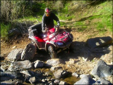
Photo Submitted 12/25/2011 (Thanks for the great shots!)
Bartlett Lake Trail Photo
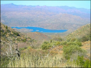
Photo Submitted 12/25/2011 (Thanks!)
Bartlett Lake Trail Photo
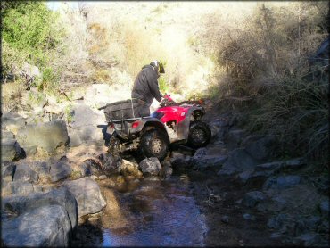
Photo Submitted 12/25/2011 (Thanks!)
Bartlett Lake Trail Photo

Photo Submitted 12/25/2011 (Thanks!)
Bartlett Lake Trail Photo
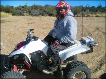
Photo Submitted 12/25/2011 (Thank You)
RIDER COMMENTS & REVIEWS