 |
      |
| Home > Arizona > Saffel Canyon |
Saffel Canyon OHV Trail
Monday, February 10, 2025
| Other Names | Apache - Sitgreaves National Forest, Mulligan Knoll, Saffell Spring, Milligan Valley, Flat Top, Round Valley, Mulligan Valley Creek, Pat Knoll |
| Last Known Status | Open |
This part of the Apache - Sitgreaves National Forest features a 21-mile linear trail (one way in, one way out), one four mile loop and a designated tot-lot that winds through a mixed ponderosa pine, conifer and pinion-juniper forest. Colorful wildflowers, grassy meadows and panoramic views of the surrounding mountains and valleys are also among the many attractions.
The trail system is well marked and rated as mostly easy-medium difficulty but note there are a few tight sections for ATVs. Most of the terrain is hard packed dirt but there are some sections that have been covered with loose gravel.
There is no fee charged to ride or park but note that the staging area is only open during daylight hours. Camping can be found near the town of Greer, Big Lake and Lyman Lake State Park.
REGULATIONS
| Permit Required | Yes | AZGFD sticker required |
| Dates Open | Year-Round | |
| Other ATV Stickers Accepted | No | All non-residents must purchase an Arizona OHV decal. |
| Spark Arrestor | Yes | A spark arresting exhaust silencer or end cap is required for all vehicles. |
| Noise Limit | Yes (96 dB) | |
| Whip Flags | Not Required | |
| Maximum Vehicle Width | Yes (50 inches) | has entrance gate or posts |
 Motorcycles & Dirt Bikes Motorcycles & Dirt Bikes | Permitted | |
 ATVs ATVs | Permitted | (maximum width 50 inches) |
 UTV & SXS UTV & SXS | Permitted | (maximum width 50 inches) |
 SUVs & Jeeps (registered) SUVs & Jeeps (registered) | Prohibited | |
| Dune Buggy & Sand Rail 4x4 (unregistered) | Prohibited | |
| 2 Stroke Engines | No Restriction | |
| MX Helmet Required | Youth Only | required for persons under 18 by state law (RiderPlanet strongly recommends helmets for all riders.) |
 Camping Camping | Some Areas | dispersed tent camping permitted, staging area is day use only |
 Campfires Campfires | Some Areas | (permitted in developed campsites only) |
| Night Riding | Unknown | |
| Trail Blazing | Prohibited | stay on trail |
| Rule Enforcement |
TYPE OF AREA
| Area | Motorized Trails |
| Land | National Forest |
FEES & PASSES
| Parking | (None) |
| Entry | (None) |
| Riding | (None) |
| Camping | (None) |
RATINGS
| Our Rating |  |
| Recommended Stay | Full Day |
| Comments | (Scroll Down For Rider Reviews & Comments) |
DRIVING DIRECTIONS
| Nearest City | Eagar, AZ | ||
| From: St. Johns, AZ
1) Take US-180 (US-191) South about 25 miles 2) Turn left to stay on US-180 (US-191), continue 8 miles 3) Turn right on SR-260 (US-180), continue 1.6 miles 4) Turn right (west) on W. Central Avenue, continue 1 block 5) Turn left (south) on S. Harless Street, continue 1 mile 6) Proceed straight through the 4-way intersection onto Water Canyon Road, continue 1.8 miles 7) Turn left (east) on FS-74, continue .9 miles 8) Turn right on FS-74D. Trailhead is on the right. |


OFFICIAL CONTACTS
| Contact Info | Apache Sitgreaves NF - Springerville Ranger District P.O. Box 640 Springerville, AZ 85938 (928) 333-6200 mailroom_r3_apache_sitgreaves@fs.fed.us www.fs.usda.gov |
Saffel Canyon Trail Photo
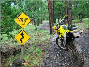
Photo Submitted 8/27/2011 (Thanks!)
Saffel Canyon Trail Photo
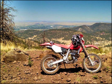
Photo Submitted 11/5/2015 (Thanks!)
Saffel Canyon Trail Photo
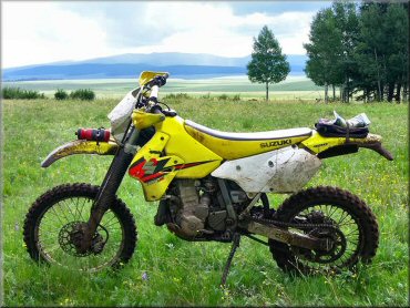
Photo Submitted 8/27/2011 (Thanks!)
ADD PHOTOS
TERRAIN
| Miles Of Trail | 25 | |
| Climate Type | Forest | |
| Elevation | 7600 to 9400 ft. | |
| Trail Maintenance | Marked, Not Rated, Heavily Maintained | |
| Loose Dirt |  Mostly Mostly | |
| Hard Pack |  Some Some | |
| Sand |  None None | |
| Mud | Some | |
| Dust |  Little Little | |
| Rocks | Little | |
| Trees |  Many Many | |
| Steep Hills | Some | |
| Hazards |  Few Few | (hazards assumed marked but use caution) |
 Novice Novice | Some | |
 Amateur Amateur | Mostly | |
 Expert Expert | Little |
GPS POINTS


KEY SERVICES
 Gasoline Gasoline | 1-5 Miles (N) | Circle K (928) 333-2346 |
| Diesel | 1-5 Miles (N) | Circle K (928) 333-2346 |
 Water Water | 5-20 Miles (W) | Rolfe C. Hoyer Campground (928) 333-6200 |
 RV Hookup RV Hookup | 5-20 Miles (SW) | Apache Trout Campground (928) 333-6200 |
 RV Disposal RV Disposal | 5-20 Miles (W) | Rolfe C. Hoyer Campground (928) 333-6200 |
| Campground | 5-20 Miles (W) | Rolfe C. Hoyer Campground (928) 333-6200 |
 Conv Store Conv Store | 1-5 Miles (N) | Circle K (928) 333-2346 |
RIDER COMMENTS & REVIEWS