 |
      |
| Home > California > Chappie-Shasta |
Chappie-Shasta OHV Area
Tuesday, March 31, 2026
| Other Names | Copley Mountain, Shasta OHV, Shasta Dam, Matheson, Shasta Offroad Park, Whiskeytown Shasta-Trinity National Recreation Area, Shasta Trinity National Forest, Big Gulch, Bohemotash Campground, Chappie Shasta OHV Area |
| Last Known Status | Open |
The trails here could be described as dry and a bit rocky, but the scenery is really top notch. Most of the trails are really wide jeep roads but there are some that are only wide enough for ATVs and dirt bikes. The trail system offers a wide variety of terrain that range from dozens of creek crossings, steep hill climbs and descents with both small and medium sized loose chunk rock.
The area offers several staging areas but the most popular one is the Chappie-Shasta Staging Area, which has some clean new facilities and is nestled right under a large dam. A campground with direct trail access is located about a 1/4 mile past this staging area which has some nice paved and shaded sites for a small fee.
There is an alternate staging area to the south (see directions) which works just fine for day use. You can reach the campground this way also, but there are three or four creek crossings, some nasty washouts, and some short sections of volleyball sized rocks.
Pickups should have no problem and short travel trailers could probably make it, but it might take you all day. For big RVs or toy haulers the northern access route (dam crossing) is highly recommended.
REGULATIONS
| Permit Required | Yes | CA OHMVR stickers required |
| Dates Open | Year-Round | CA OHMVR red sticker vehicles permitted from 10/1 to 5/31 |
| Other ATV Stickers Accepted | Yes | Residents of any state not listed must purchase a Nonresident OHV Use Permit. (AR, AZ, CA, CO, CT, DE, IA, ID, IN, LA, MA, MD, ME, MI, MN, MO, MT, ND, NH, NJ, NM, NV, NY, OH, OK, OR, PA, RI, TX, UT, VT, WA, WI, WY) |
| Spark Arrestor | Yes | A spark arresting exhaust silencer or end cap is required for all vehicles. |
| Noise Limit | Yes (96 dB) | CA OHMVR noise limits apply (1985/older limit 101 dB, 1986/newer limit 96 dB) |
| Whip Flags | Not Required | |
| Maximum Vehicle Width | Yes (64 inches) | has entrance gate or posts |
 Motorcycles & Dirt Bikes Motorcycles & Dirt Bikes | Permitted | CA OHMVR stickers required |
 ATVs ATVs | Permitted | CA OHMVR stickers required |
 UTV & SXS UTV & SXS | Permitted | CA OHMVR stickers required (maximum width 64 inches) |
 SUVs & Jeeps (registered) SUVs & Jeeps (registered) | Some Areas | |
| Dune Buggy & Sand Rail 4x4 (unregistered) | Some Areas | CA OHMVR stickers required (maximum width 64 inches) |
| 2 Stroke Engines | Certain Times | CA OHMVR restrictions apply |
| MX Helmet Required | Yes | helmets required by state law |
 Camping Camping | Some Areas | (camp in developed sites only) |
 Campfires Campfires | Some Areas | (permitted in developed campsites only) |
| Night Riding | Unknown | Not Recommended |
| Trail Blazing | Prohibited | vehicles must stay on trail |
| Alcohol | No Restriction | |
| Rule Enforcement | Few/Periodic | Dedicated Rangers/Officers Jeep/SUV Patrol |
TERRAIN
| Approx Size | 52,000 acres (81 sq mi) | |
| Miles Of Trail | 250 | |
| Climate Type | Forest | |
| Elevation | 1000 to 5000 ft. | |
| Trail Maintenance | Marked, Rated, Lightly Maintained | |
| Loose Dirt |  Some Some | |
| Hard Pack | Some | |
| Sand | Some | |
| Mud |  Little Little | |
| Dust | Some | |
| Rocks | Some | |
| Trees |  All All | |
| Steep Hills |  Many Many | |
| Water Crossings | Many | |
| Small Jumps |  Few Few | |
| Large Jumps |  None None | |
| Berms | Few | |
| Sand/Gravel Pits | None | |
| Single Track | Some | |
| Roads | Some | |
| Intersections | Few | |
| Rider Traffic | Few | |
| Shade | Many | |
| Ranges/Gunfire | None | |
| Hazards | Some | (hazards not marked) some very steep hills |
 Novice Novice | Some | |
 Amateur Amateur |  Mostly Mostly | |
 Expert Expert | Some | |
| Comment | trails are marked for difficulty | |
TYPE OF AREA
| Area | Motorized Trails |
| Land | BLM, National Forest |
GPS POINTS


KEY SERVICES
 Gasoline Gasoline | 5-20 Miles (NE) | 7-11 (530) 246-2291 |
| Diesel | 5-20 Miles (NE) | 7-11 (530) 246-2291 |
 Water Water | On Site | Shasta Campground (530) 224-2100 |
 RV Hookup RV Hookup | 5-20 Miles (NE) | Mountain Gate RV Park (530) 275-4600 |
 RV Disposal RV Disposal | 5-20 Miles (NE) | Mountain Gate RV Park (530) 275-4600 |
| Campground | On Site | Shasta Campground (530) 224-2100 |
 Conv Store Conv Store | 5-20 Miles (NE) | Chevron (530) 275-2775 |
FEES & PASSES
| Parking | (None) |
| Entry | (None) |
| Riding | (None) |
| Camping | Yes Tent: $20.00 RV: $20.00 Addtl. Vehicle: $6.00 Shasta Campground Fee |
RATINGS
| Pros | beautiful scenery, lots of creek crossings, places to swim and fish, nice facilities |
| Cons | a little dry, a little rocky |
| Our Rating |  Very Good Very Good |
| Recommended Stay | 3-5 Days |
| Comments | (Scroll Down For Rider Reviews & Comments) |
DRIVING DIRECTIONS
| Nearest City | Redding, CA | ||
| Address | Coram Road, Redding, CA 96001 | ||
| From: Redding, CA
1) Take I-5 N to Exit 685 2) Merge onto Shasta Dam Blvd, continue about 7 miles 3) Proceed though roundabout toward entrance for Shasta Dam, cross dam* 4) After crossing dam, turn left (south) onto Whiskeytown-Shasta Trinity Road (road names changes to Coram Road), continue 1.3 miles 5) Chappie-Shasta Staging Area is on the right. For campground continue .3 miles past staging area. *Note: A valid driver’s license and vehicle registration is required to cross the dam. Vehicle may be subject to inspection. For Matheson Access: 1) Take I-5 North to Exit 678 2) Veer left at the fork and merge onto CA-44, continue 1.2 miles 3) Turn right (north) onto Pine Street, continue 1 block 4) Veer left (west) onto Eureka Way/CA-299, continue 4.9 miles 5) Turn right (north) onto Iron Mountain Road, continue 6 miles 6) Turn right (east) onto Matheson Road. "Copley Mountain" staging area is on the right (GPS coords: N40.39.536 122.28.136W). |


OFFICIAL CONTACTS
| Contact Info | BLM - Redding Field Office 6640 Lockheed Drive Redding, CA 96002 (530) 224-2100 blm_ca_web_re@blm.gov www.blm.gov |
| Comment | Trail Hotline |
| Contact Info | Bureau of Reclamation Shasta Dam Visitor Center 16349 Shasta Dam Boulevard Shasta Lake, CA 96019 (530) 275-1554 fbarajas@usbr.gov www.usbr.gov |
Chappie-Shasta Trail Photo
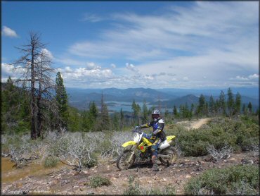
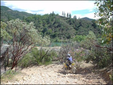
These trails have some stunning scenic views of Shasta Dam. This was taken along the main loop.
Chappie-Shasta Trail Photo
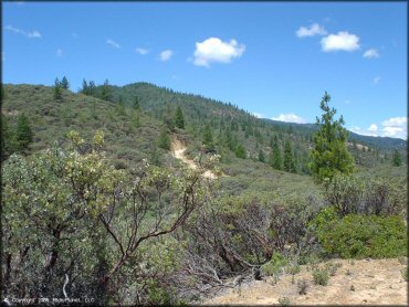
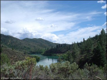
There is some great mountain scenery too. The main loop follows the ridge of these hills before dropping back down to the staging area under the dam.
Chappie-Shasta Trail Photo
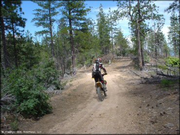
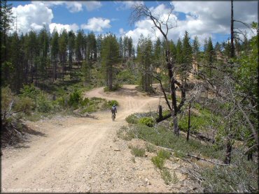
Many of the trails are pretty smooth and easy. You can make good time, or take in the scenery. There are multiple places to stop and get a panoramic view.
Chappie-Shasta Trail Photo
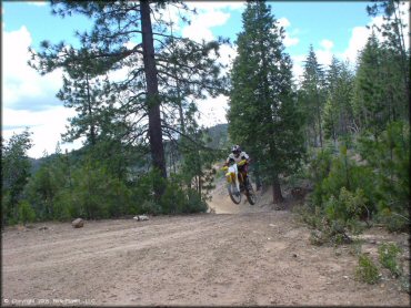
This was a fun little rise along one of the main arteries. Along the main loop most of the trails were wide, basically jeep roads.
Chappie-Shasta Trail Photo
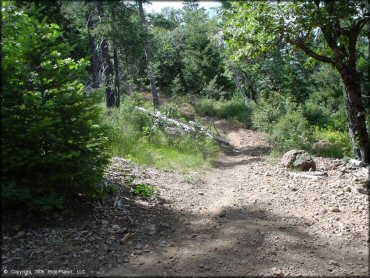
Not all of the trails are jeep roads. There are also some narrow trails like this.
Chappie-Shasta Trail Photo
This is a view from the main trail very near the main staging area.
Chappie-Shasta Trail Photo
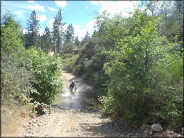
There are a few shallow water crossings, mostly along the access road that follows the river. Nothing too deep, kind of fun.
Chappie-Shasta Trail Photo
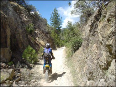
This was a cool canyon walled section of the main trail.
Chappie-Shasta Trail Photo
Coming down the last hill back to the staging area. A loose rocky descent of medium difficulty.
Chappie-Shasta Trail Photo
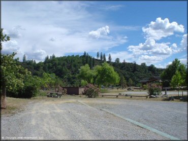
This is the main parking and day use staging area located below the dam. Amenities include picnic tables, loading ramps and a vault toilet.
Chappie-Shasta Trail Photo
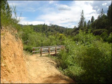
A bridge on one of the trails.
Chappie-Shasta Trail Photo
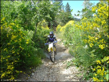
There is even some colorful vegetation that surrounds some of the trails.
Chappie-Shasta Trail Photo
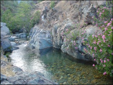
There is a shallow swimming hole located along the main access road that follows the river.
Chappie-Shasta Trail Photo
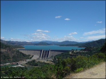
A view of Shasta Dam from the road.
Chappie-Shasta Trail Photo
This is one of the upper elevation sections of the main loop.
Chappie-Shasta Trail Photo
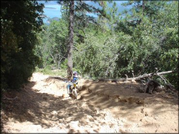
A few of the trails have a layer of sharp rocks the size of softballs or volleyballs, but only in certain sections. Most of the trails are very tame.
RIDER COMMENTS & REVIEWS