 |
      |
| Home > California > Cleghorn |
Cleghorn OHV Trail
Monday, July 28, 2025
| Other Names | Cleghorn Fire Rd, Cleghorn Ridge, Cleghorn Rd, Cajon Pass, San Bernardino National Forest, Powell Canyon, Sugarpine Spring, Silverwood Lake, Summit Trailhead, Summit OHV |
| Last Known Status | Open |
This old fire road is about 15 miles long and eventually ends near Silverwood Lake. The trail itself is rated easy, but there are a few side spurs that may offer a little bit of challenge. The terrain is mostly hard pack dirt with a few rugged sections but is wide enough for jeeps. The scenery is pleasant and offers some nice views of the San Bernardino Mountains and the lake.
The staging area off Cajon Pass is small and narrow and just big enough for a few compact trucks. RVs and trailers are advised to park at Summit OHV Staging area off Hwy 138, which offers plenty of room for parking, several picnic tables, garbage cans and a vault toilet. There is no shade structures and overnight parking is not permitted.
The trail is open year-round but may close on short notice during and after poor weather conditions or during fire season. All machines must display a current OHV registration sticker and Adventure Pass which can be purchased online or at nearby ranger stations.
REGULATIONS
| Permit Required | Yes | CA OHMVR stickers required |
| Dates Open | Year-Round | CA OHMVR red sticker vehicles permitted from Oct 1 to April 30 |
| Other ATV Stickers Accepted | Yes | Residents of any state not listed must purchase a Nonresident OHV Use Permit. (AR, AZ, CA, CO, CT, DE, IA, ID, IN, LA, MA, MD, ME, MI, MN, MO, MT, ND, NH, NJ, NM, NV, NY, OH, OK, OR, PA, RI, TX, UT, VT, WA, WI, WY) |
| Spark Arrestor | Yes | A spark arresting exhaust silencer or end cap is required for all vehicles. |
| Noise Limit | Yes (96 dB) | CA OHMVR noise limits apply (1985/older limit 101 dB, 1986/newer limit 96 dB) |
| Whip Flags | Not Required | |
| Maximum Vehicle Width | No Restriction | |
 Motorcycles & Dirt Bikes Motorcycles & Dirt Bikes | Permitted | CA OHMVR stickers required |
 ATVs ATVs | Permitted | CA OHMVR stickers required |
 UTV & SXS UTV & SXS | Permitted | CA OHMVR stickers required |
 SUVs & Jeeps (registered) SUVs & Jeeps (registered) | Permitted | |
| Dune Buggy & Sand Rail 4x4 (unregistered) | Permitted | CA OHMVR stickers required |
| 2 Stroke Engines | Certain Times | CA OHMVR restrictions apply |
| MX Helmet Required | Yes | helmets required by state law |
 Camping Camping | Some Areas | (camp in developed sites only) |
 Campfires Campfires | Some Areas | (permitted in developed campsites only) |
| Night Riding | Yes | Not Recommended |
| Trail Blazing | Prohibited | no trailblazing |
| Alcohol | No Restriction | |
| Rule Enforcement | Few/Periodic |
TERRAIN
| Approx Size | 3,200 acres (5 sq mi) | |
| Miles Of Trail | 15 | |
| Climate Type | Forest | |
| Elevation | 3100 to 4500 ft. | |
| Trail Maintenance | Marked, Rated, Lightly Maintained | |
| Loose Dirt |  Little Little | |
| Hard Pack |  Mostly Mostly | |
| Sand |  None None | |
| Mud | Little | |
| Dust | Little | |
| Rocks | Little | |
| Trees |  Some Some | |
| Steep Hills | Some | |
| Small Jumps |  Few Few | |
| Large Jumps | None | |
| Berms | None | |
| Sand/Gravel Pits | None | |
| Single Track | None | |
| Roads |  All All | |
| Intersections | Few | |
| Rider Traffic | Few | |
| Shade | Few | |
| Ranges/Gunfire | None | |
| Hazards | Few | (hazards not marked) |
 Novice Novice | Some | |
 Amateur Amateur | Mostly | |
 Expert Expert | Little |
TYPE OF AREA
| Area | Motorized Trails |
| Land | National Forest |
GPS POINTS


KEY SERVICES
 Gasoline Gasoline | 1-5 Miles (N) | Chevron (760) 249-4575 |
| Diesel | 1-5 Miles (N) | Chevron (760) 249-4575 |
 Water Water | 1-5 Miles (SW) | Mountain Lakes Campground (909) 887-7070 |
 RV Hookup RV Hookup | 1-5 Miles (SW) | Mountain Lakes Campground (909) 887-7070 |
 RV Disposal RV Disposal | 1-5 Miles (SW) | Mountain Lakes Campground (909) 887-7070 |
| Campground | 5-20 Miles (SW) | Applewhite Campground (909) 382-2881 |
 Conv Store Conv Store | 1-5 Miles (N) | Chevron (760) 249-4575 |
FEES & PASSES
| Parking | Yes ($5.00) Adventure Pass Fee - $5/day or $30/year |
| Entry | (None) |
| Riding | (None) |
| Camping | (None) |
RATINGS
| Pros | great scenery |
| Cons | staging area is very small, no single track, not really a trail, just an old road |
| Our Rating |  Fair Fair |
| Recommended Stay | Full Day |
| Comments | (Scroll Down For Rider Reviews & Comments) |
DRIVING DIRECTIONS
| Nearest City | San Bernardino, CA | ||
| Address | Cleghorn Road, Phelan, CA 92371 | ||
| From: San Bernardino, CA
1) Take I-15 North to Exit 129 2) Turn right (east) off the exit ramp, continue about 25 yards. 3) Stage at side of road. For Summit OHV Staging Area: 1) Take I-15 to Exit 131 2) Turn right (east) off the exit ramp onto Hwy 138, continue 4 miles 3) Turn right (south) on FS Road 3N22/Cleghorn Road, continue .5 miles 4) Staging area is on the right (west). |


OFFICIAL CONTACTS
| Contact Info | San Bernardino National Forest - Lytle Creek Ranger Station 1209 Lytle Creek Road Lytle Creek, CA 92358 (909) 382-2851 mailroom_r5_san_bernardino@fs.fed.us www.fs.usda.gov |
| Contact Info | Big Bear Discovery Center 40971 North Shore Drive Fawnskin, CA 92338 (909) 382-2790 www.fs.usda.gov |
| Comment | Sells Adventure Passes |
Cleghorn Trail Photo
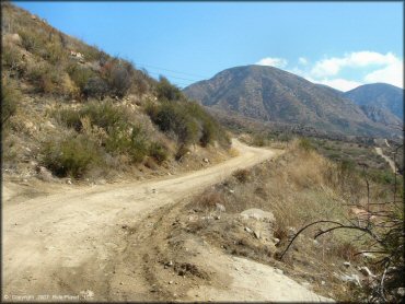
The trail is mostly wide and smooth, making it a good spot to bring novices. The scenery is nice too, but there is no shade or water.
Cleghorn Trail Photo
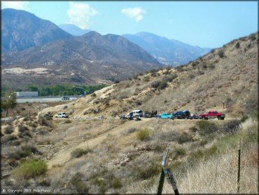
The staging area is tiny. If your vehicle is not small enough to fit on the shoulder you will have difficulty. Those with long trailers should park at Summit OHV Staging Area, which is north at Cajon Pass.
Cleghorn Trail Photo
This trail is a good place to bring the family.
Cleghorn Trail Photo
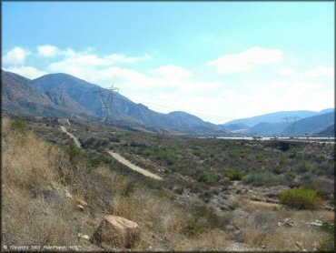
This is the beginning of the trail near Cajon Junction.
Cleghorn Trail Photo
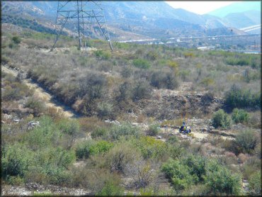
For a short distance, the trail follows the interstate but heads in a northeast direction toward Silverwood Lake.
Cleghorn Trail Photo
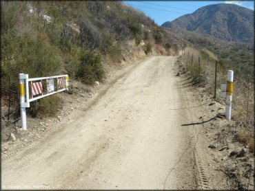
This gate is locked when the trail is closed.
Cleghorn Trail Photo
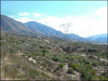
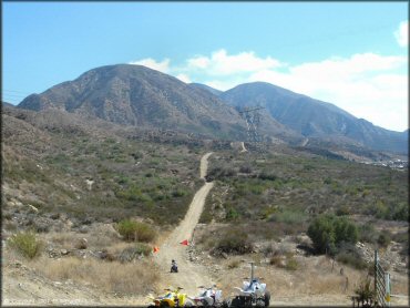
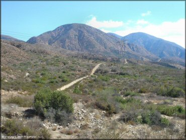
From Cajon Junction the trail heads east underneath the powerlines. From here you can see I-15 in the distance.
Cleghorn Trail Photo
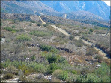
Another view of the old fire road. The trail heads east and eventually ends near Silverwood Lake, which has camping, beaches and boat ramps. This is a good place for an easy offroad trip in a 4x4.
Cleghorn Trail Photo
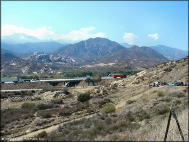
The staging area is located right off I-15.
Cleghorn Trail Photo
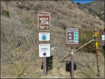
The signage shows that the trail is marked as easy and open to dirt bikes, ATVs and jeeps.
Cleghorn Trail Photo
RIDER COMMENTS & REVIEWS