 |
      |
| Home > California > Ballinger Canyon |
Ballinger Canyon OHV Area
Tuesday, March 31, 2026
| Other Names | Mt. Pinos Ranger District, Balinger, Los Padres National Forest, Deer Park |
| Last Known Status | Open |
This popular off-road area has about 68 miles of marked and rated ATV trails on public land. The terrain ranges from hard packed 4x4 roads, twisty sand washes, rugged and steep black diamond hill climbs and narrow single track for motorcycles. If you manage to leave the valley floor and make it to the top of the hills bring the camera - the views are stunning!
While most of the trails cater to skilled riders, there are some wide forest service roads, makeshift motocross tracks and play areas that are perfect for beginners or mini bikes. Overall this is a great place to bring the family or a large group for a weekend of riding and camping.
This area has a separate day use staging area that is located adjacent to the RV campground, which has 13 pull through sites that come with a picnic table and fire ring. A vault toilet and information kiosk is also provided. Shade is limited and there is no water so bring your own camping supplies.
REGULATIONS
| Permit Required | Yes | CA OHMVR stickers required |
| Dates Open | Daily Year-Round | CA OHMVR red sticker vehicles permitted from 10/1 to 4/30 |
| Other ATV Stickers Accepted | Yes | Residents of any state not listed must purchase a Nonresident OHV Use Permit. (AR, AZ, CA, CO, CT, DE, IA, ID, IN, LA, MA, MD, ME, MI, MN, MO, MT, ND, NH, NJ, NM, NV, NY, OH, OK, OR, PA, RI, TX, UT, VT, WA, WI, WY) |
| Spark Arrestor | Yes | A spark arresting exhaust silencer or end cap is required for all vehicles. |
| Noise Limit | Yes (96 dB) | CA OHMVR noise limits apply (1985/older limit 101 dB, 1986/newer limit 96 dB) |
| Whip Flags | Not Required | |
| Maximum Vehicle Width | No Restriction | |
 Motorcycles & Dirt Bikes Motorcycles & Dirt Bikes | Permitted | CA OHMVR stickers required |
 ATVs ATVs | Some Areas | CA OHMVR stickers required some trails allow motorcycles only |
 UTV & SXS UTV & SXS | Some Areas | CA OHMVR stickers required |
 SUVs & Jeeps (registered) SUVs & Jeeps (registered) | Some Areas | some trails allow ATVs or motorcycles only |
| Dune Buggy & Sand Rail 4x4 (unregistered) | Some Areas | CA OHMVR stickers required |
| 2 Stroke Engines | Certain Times | CA OHMVR restrictions apply |
| MX Helmet Required | Yes | helmets required by state law |
 Camping Camping | Some Areas | (camp in developed sites only) permitted at Ballinger Campground |
 Campfires Campfires | Some Areas | (permitted in developed campsites only) permitted at Ballinger Campground |
| Night Riding | No | quiet hours 10pm-6am |
| Trail Blazing | Prohibited | stay on designated trails |
| Rule Enforcement | Some | Jeep/SUV Patrol |
TERRAIN
| Approx Size | 20,063 acres (31 sq mi) | |
| Miles Of Trail | 68 | |
| Climate Type | Desert | |
| Elevation | 3000 to 4400 ft. | |
| Trail Maintenance | Marked, Rated, Lightly Maintained | |
| Loose Dirt |  Little Little | |
| Hard Pack |  Mostly Mostly | |
| Sand |  Some Some | |
| Mud |  None None | |
| Dust | Some | |
| Rocks | Some | |
| Trees |  Few Few | |
| Steep Hills |  Many Many | |
| Water Crossings | None | |
| Small Jumps | Some | |
| Large Jumps | Few | |
| Berms | Many | |
| Sand/Gravel Pits | None | |
| Single Track | Some | |
| Roads | Few | |
| Shade | Few | |
| Hazards | Few | (hazards assumed marked but use caution) |
 Novice Novice | Some | |
 Amateur Amateur | Mostly | |
 Expert Expert | Some |
TYPE OF AREA
| Area | Motorized Trails |
| Land | National Forest |
GPS POINTS


KEY SERVICES
 Gasoline Gasoline | 5-20 Miles (NE) | Shell (661) 769-8944 |
| Diesel | 5-20 Miles (NE) | Shell (661) 769-8944 |
 Water Water | 30+ Miles (S) | Lake Casitas Recreation Area (805) 649-2233 |
 RV Hookup RV Hookup | 30+ Miles (S) | Lake Casitas Recreation Area (805) 649-2233 |
 RV Disposal RV Disposal | 30+ Miles (S) | Lake Casitas Recreation Area (805) 649-2233 |
| Campground | On Site | |
 Conv Store Conv Store | 5-20 Miles (NW) | C & H Market (661) 766-2761 |
FEES & PASSES
| Parking | Yes ($10.00) Annual Pass - $50 |
| Entry | (None) |
| Riding | (None) |
| Camping | Yes Tent: $30.00 RV: $30.00 Addtl. Vehicle: $10.00 Ballinger Campground Fee |
| Comment | Adventure Pass not required to park here. Area is managed by private concessionaire on behalf of the Forest Service. Self pay kiosks are located at staging area and campground. |
RATINGS
| Our Rating |  Good Good |
| Recommended Stay | Full Day |
| Comments | (Scroll Down For Rider Reviews & Comments) |
DRIVING DIRECTIONS
| Nearest City | Cuyama, CA | ||
| Address | Ballinger Canyon Road, Cuyama, CA 93254 | ||
| From: Bakersfield, CA
1) Take I-5 South to Exit 244 2) Turn right (west) onto SR-119/Taft Hwy, continue about 20 miles 3) Merge onto CA-33 South, continue 6.3 miles 4) Turn right (west) onto Poso/Klipstein Street (road name changes to Hwy 166/West Side Hwy), continue 13.8 miles 5) Veer left (south) onto CA-33, continue 3.5 miles 6) Turn left (east) onto Ballinger Canyon Road, continue about 3 miles toward staging area. |


OFFICIAL CONTACTS
| Contact Info | Los Padres National Forest - Mt. Pinos Ranger District 34580 Lockwood Valley Road Frazier Park, CA 93225 (661) 245-3731 mailroom_r5_los_padres@fs.fed.us www.fs.usda.gov |
| Comment | select option 3 for trail conditions |
| Contact Info | Parks Management Company P.O. Box 1018 Templeton, CA 93465 (805) 434-1996 customerservice@pmcparks.com campone.com |
Ballinger Canyon Trail Photo
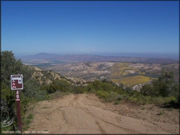
All motorized trails are clearly marked with difficulty levels and the permitted vehicles. For instance this trail is for motorcycles only. UTVs and ATVs are prohibited.
Ballinger Canyon Trail Photo
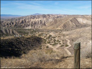
This is a photo of the ATV unloading area and the RV campground.
Ballinger Canyon Trail Photo
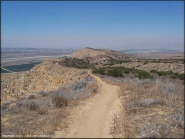
The perimeter trails offer some great scenic views. This is a motorcycle only trail but there are plenty of trails wide enough for a UTV.
Ballinger Canyon Trail Photo
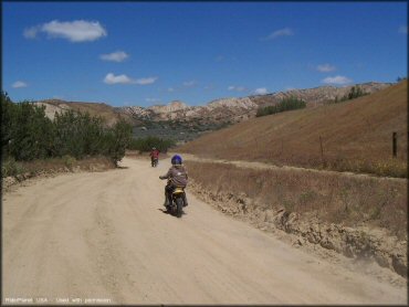
Trail 24 is rated easy and is the main artery to some of the tougher trails. It is great for mini dirt bikes and low powered UTVs.
RIDER COMMENTS & REVIEWS