 |
      |
| Home > California > Carlsbad Raceway |
Carlsbad Raceway
Saturday, December 23, 2023
| Other Names | Carlsbad Mx |
| Last Known Status | Destroyed |
Once a popular track for over thirty years and famous for its long uphill and downhill sections, the track closed back in 2004 and has since been turned into a business park. Only a few segments of the track remain. This review will remain for historical and informational purposes only.
REGULATIONS
| Permit Required | ||
| Dates Open | Track no longer exists, land has been redeveloped. | |
| Spark Arrestor | Recommended | A spark arresting exhaust silencer or end cap is recommended. |
| Noise Limit | ||
| Whip Flags | ||
| Maximum Vehicle Width | ||
 Motorcycles & Dirt Bikes Motorcycles & Dirt Bikes | Prohibited | |
 ATVs ATVs | Prohibited | |
 UTV & SXS UTV & SXS | Prohibited | |
 SUVs & Jeeps (registered) SUVs & Jeeps (registered) | Prohibited | |
| Dune Buggy & Sand Rail 4x4 (unregistered) | Prohibited | |
| 2 Stroke Engines | No Restriction | |
 Camping Camping | ||
 Campfires Campfires | ||
| Night Riding | No | |
| Trail Blazing | Prohibited | |
| Rule Enforcement |
Advertisement
TYPE OF AREA
| Area | Multi-Use Area |
| Land | Privately Owned / Commercial |
FEES & PASSES
| Parking | (Unknown) |
| Entry | (Unknown) |
| Riding | (Unknown) |
| Camping | (Unknown) |
RATINGS
| Our Rating |  Good Good |
| Recommended Stay | Full Day |
| Comments | (Scroll Down For Rider Reviews & Comments) |
DRIVING DIRECTIONS
| Nearest City | San Marcos, CA | ||
| From: Escondido, CA
1) Area permanently closed. No visitors please. |


OFFICIAL CONTACTS
Carlsbad Raceway Riding Area Photo
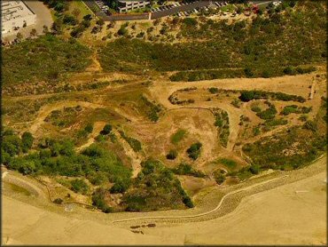
Photo Submitted 7/6/2012 (Thanks!)
ADD PHOTOS
TERRAIN
| Approx Size | 143 acres | |
| Climate Type | Urban/Man-Made | |
| Elevation | 350 to 450 ft. | |
| Trail Maintenance | Unknown | |
| Hazards |  Few Few | (hazards assumed marked but use caution) |
 Novice Novice |  Some Some | |
 Amateur Amateur |  Mostly Mostly | |
 Expert Expert |  Little Little |
GPS POINTS
KEY SERVICES
 Gasoline Gasoline | San Marcos, CA | |
| Diesel | San Marcos, CA | |
 Water Water | San Marcos, CA | |
 RV Hookup RV Hookup | San Marcos, CA | |
 RV Disposal RV Disposal | San Marcos, CA | |
| Campground | San Marcos, CA | |
 Conv Store Conv Store | San Marcos, CA |
RIDER COMMENTS & REVIEWS