 |
      |
| Home > Colorado > Rimrocker Trail |
Rimrocker Trail
Saturday, December 23, 2023
| Other Names | Uncompahgre National Forest, Ouray Ranger District, Manti-la Sal National Forest, Moab Ranger District, Tabeguache Creek, San Miguel River, Dolores River, Rim Rocker Trail |
| Last Known Status | Open |
This offroad trail spans 160 miles and runs east to west from Montrose, Colorado to Moab, Utah. The trail is mostly and old but maintained mining road that winds between canyons, streams, rivers, rugged hill sides and boulders while offering stunning views of aspen, pine and juniper trees.
Most of the terrain consists of hard packed roads with occasional loose chunk rock. The trail is well marked and there are several kiosks with maps scattered throughout the route, plus several Forest Service campgrounds that permit direct trail access. Iron Springs and Columbine campgrounds are free but the campground at Buckeye Reservoir charges a small nightly fee.
Since the trail crosses both Colorado and Utah state lines, visitors need to obtain both Utah and Colorado offroad stickers. There is a short segment of paved road (Hwy 141) that needs to be crossed to complete the route (vehicles must be street legal to cross this section). The county is currently working on a bypass for non-street legal vehicles.
REGULATIONS
| Permit Required | Yes | Colorado OHV and Utah Sticker |
| Dates Open | Year-Round | |
| Other ATV Stickers Accepted | No | Colorado and Utah Non-Resident OHV permit required. |
| Spark Arrestor | Yes | A spark arresting exhaust silencer or end cap is required for all vehicles. |
| Noise Limit | Yes (96 dB) | |
| Whip Flags | Not Required | |
| Maximum Vehicle Width | No Restriction | |
 Motorcycles & Dirt Bikes Motorcycles & Dirt Bikes | Permitted | |
 ATVs ATVs | Permitted | |
 UTV & SXS UTV & SXS | Permitted | |
 4x4 & Jeeps (registered) 4x4 & Jeeps (registered) | Permitted | |
| Dune Buggy & Sand Rail 4x4 (unregistered) | Permitted | |
| 2 Stroke Engines | No Restriction | |
 Camping Camping | Some Areas | (camp in developed sites only) |
 Campfires Campfires | ||
| Night Riding | Unknown | |
| Trail Blazing | Prohibited | stay on trails |
| Rule Enforcement |
TERRAIN
| Miles Of Trail | 160 | |
| Climate Type | Forest | |
| Elevation | 5600 to 9840 ft. | |
| Trail Maintenance | Marked, Not Rated, Lightly Maintained | trail is marked with fluorescent green posts |
| Loose Dirt |  Little Little | |
| Hard Pack |  Mostly Mostly | |
| Sand |  None None | |
| Mud |  Some Some | |
| Dust | Some | |
| Rocks | Little | |
| Trees |  Many Many | |
| Steep Hills | Some | |
| Water Crossings | Some | |
| Small Jumps | None | |
| Large Jumps | None | |
| Berms | None | |
| Sand/Gravel Pits | None | |
| Single Track | None | |
| Roads |  All All | |
| Shade | Many | |
| Hazards |  Few Few | (hazards assumed marked but use caution) |
 Novice Novice | Mostly | |
 Amateur Amateur | Little | |
 Expert Expert | None |
TYPE OF AREA
| Area | Motorized Trails |
| Land | BLM, National Forest, County Land |
GPS POINTS


KEY SERVICES
 Gasoline Gasoline | Montrose, CO | |
| Diesel | Montrose, CO | |
 Water Water | Montrose, CO | |
 RV Hookup RV Hookup | Montrose, CO | |
 RV Disposal RV Disposal | Montrose, CO | |
| Campground | Montrose, CO | |
 Conv Store Conv Store | Montrose, CO |
FEES & PASSES
| Parking | (None) |
| Entry | (None) |
| Riding | (None) |
| Camping | Yes Tent: $10.00 RV: $10.00 Addtl. Vehicle: $0.00 Pioneer Camground - $10/night. No fee charged at Iron Springs or Columbine campgrounds. |
RATINGS
| Our Rating |  Good Good |
| Recommended Stay | 3-5 Days |
| Comments | (Scroll Down For Rider Reviews & Comments) |
DRIVING DIRECTIONS
| Nearest City | Montrose, CO | ||
| From: Montrose, CO
1) Take County Road 90 west 8.8 miles 2) Staging area is on the left (south). From Moab, Utah: 1) Take Hwy 191 South about 7 miles 2) Turn left (east) onto Old Airport Road, continue .6 miles 3) Turn right (south) onto La Sal Mountain Loop, continue about 1 mile 4) Trailhead is on the right. |


OFFICIAL CONTACTS
| Contact Info | BLM - Uncompahgre Field Office 2465 South Townsend Avenue Montrose, CO 81401 (970) 240-5300 blm_co_info@blm.gov www.blm.gov |
| Contact Info | Uncompahgre National Forest - Ouray Ranger District 2505 S. Townsend Ave Montrose, CO 81401 (970) 240-5300 sm.fs.r2gmuginfo@usda.gov www.fs.usda.gov |
| Contact Info | Manti-la Sal National Forest - Moab Ranger District 62 East 100 North Moab, UT 84532 (435) 259-7155 ryan.nehl@usda.gov www.fs.usda.gov |
| Contact Info | Montrose County - Rimrocker Trail 317 South 2nd Street Montrose, CO 81401 (970) 249-7755 pr@montrosecounty.net rimrockertrail.org |
Rimrocker Trail Photo
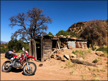
Photo Submitted 12/13/2020 (Thanks!)
Rimrocker Trail Photo
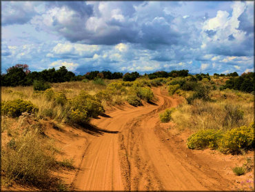
Photo Submitted 12/13/2020 (Thanks!)
Rimrocker Trail Photo
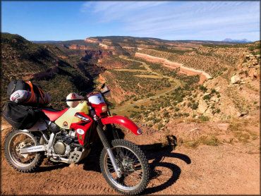
Photo Submitted 12/13/2020 (Thanks!)
Rimrocker Trail Photo
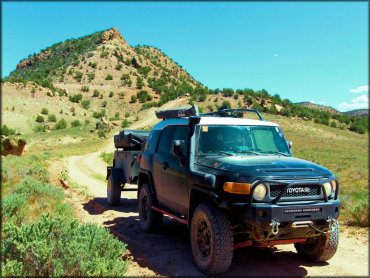
Photo Submitted 12/13/2020 (Thanks!)
Rimrocker Trail Photo
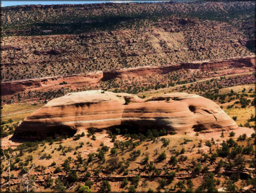
Photo Submitted 12/13/2020 (Thanks!)
Rimrocker Trail Photo
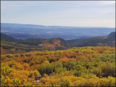
Photo Submitted 12/13/2020 (Thanks!)
Rimrocker Trail Photo
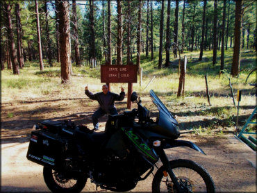
Photo Submitted 12/13/2020 (Thanks!)
Rimrocker Trail Photo
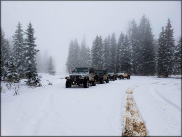
Photo Submitted 12/13/2020 (Thanks!)
RIDER COMMENTS & REVIEWS