 |
      |
| Home > Michigan > Tomahawk |
Tomahawk Motorcycle Trail
Saturday, December 23, 2023
| Other Names | Indian River ATV Trail, Mackinaw State Forest, Cheboygan County, Burt Lake, Emmet County, Charlevoix County, A Trail, B Trail, C Trail |
| Last Known Status | Open |
The Cheboygan County area features three trail loops of varying difficulty. Loop A is for motorcycles and ATVs up to 50 inches wide while loops B and C are for motorcycles only.
Tomahawk usually refers to the trail loops that allow motorcycles and ATVs only, but the nearby Indian River ATV Trail allow Jeeps and other off-road vehicles. Other nearby recreational opportunities include swimming, boating, hiking, whitewater rafting and more. This area is also popular for snowmobiling during the winter.
REGULATIONS
| Permit Required | Yes | MI ORV Sticker |
| Dates Open | Year-Round | |
| Other ATV Stickers Accepted | No | MI ORV permit required. |
| Spark Arrestor | Yes | A spark arresting exhaust silencer or end cap is required for all vehicles. |
| Noise Limit | Yes | |
| Whip Flags | Not Required | |
| Maximum Vehicle Width | Yes (50 inches) | has entrance gate or posts |
 Motorcycles & Dirt Bikes Motorcycles & Dirt Bikes | Permitted | |
 ATVs ATVs | Some Areas | (maximum width 50 inches) permitted on loop A |
 UTV & SXS UTV & SXS | Some Areas | (maximum width 50 inches) permitted on loop A |
 SUVs & Jeeps (registered) SUVs & Jeeps (registered) | Prohibited | |
| Dune Buggy & Sand Rail 4x4 (unregistered) | Prohibited | |
| 2 Stroke Engines | No Restriction | |
| MX Helmet Required | Yes | required by state law |
 Camping Camping | Some Areas | |
 Campfires Campfires | ||
| Night Riding | Unknown | Not Recommended |
| Trail Blazing | Prohibited | stay on trail |
| Rule Enforcement | Few/Periodic | Jeep/SUV Patrol |
Advertisement
TYPE OF AREA
| Area | Motorized Trails |
| Land | State Forest, County Land |
FEES & PASSES
| Parking | (None) |
| Entry | (None) |
| Riding | (None) |
| Camping | (None) |
RATINGS
| Our Rating |  Very Good Very Good |
| Recommended Stay | Full Day |
| Comments | (Scroll Down For Rider Reviews & Comments) |
DRIVING DIRECTIONS
| Nearest City | Indian River, MI | ||
| From: Flint, MI
1) Take I-75 North 190 miles to Wolverine 2) Exit at Afton Road (exit 301), turn left (west), continue .7 miles 3) Turn left (south) on Old 27 , continue 0.1 miles 4) Turn right (west) on W Main Street / Wolverine Road, continue 6.25 miles 5) Turn left (west) on Peru Road, continue 1.3 miles 6) Turn left (south) on Springvale Road, continue about 0.2 miles 7) Staging area is on the right. |


OFFICIAL CONTACTS
| Contact Info | Indian River Tourist Bureau Indian River, MI (231) 238-9325 info@irtourism.com www.irtourism.com |
| Contact Info | Michigan Department of Natural Resources P.O. Box 30181 Lansing, MI 48909 (517) 373-1204 dnr-trails@michigan.gov www.michigan.gov |
| Comment | MI ORV Sticker Info |
| Contact Info | Cycle Conservation Club of Michigan (517) 416-0126 cccboard@cycleconservationclub.org |
Tomahawk Trail Photo
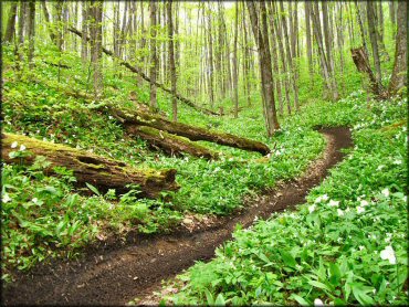
Photo Submitted 11/30/2011 (Thanks!)
ADD PHOTOS
TERRAIN
| Approx Size | 10,240 acres (16 sq mi) | |
| Miles Of Trail | 23 | |
| Climate Type | Forest | |
| Elevation | 600 to 1000 ft. | |
| Trail Maintenance | Marked, Rated, Heavily Maintained | |
| Loose Dirt |  Some Some | |
| Hard Pack | Some | |
| Sand |  Little Little | |
| Mud | Little | |
| Dust | Little | |
| Rocks | Little | |
| Trees |  All All | |
| Steep Hills |  Few Few | |
| Water Crossings | Few | |
| Small Jumps | Some | |
| Large Jumps |  None None | |
| Berms |  Many Many | |
| Sand/Gravel Pits | None | |
| Single Track | Few | |
| Roads | Few | |
| Intersections | Few | |
| Rider Traffic | Few | |
| Shade | Many | |
| Ranges/Gunfire | None | |
| Hazards | Few | (hazards are marked) |
 Novice Novice | Some | |
 Amateur Amateur |  Mostly Mostly | |
 Expert Expert | Little |


KEY SERVICES
 Gasoline Gasoline | 1-5 Miles (N) | EZ Mart (231) 238-9633 |
| Diesel | 5-20 Miles (S) | The Dairy Barn (231) 525-8540 |
 Water Water | 5-20 Miles (E) | Yogi Bear's Jellystone Park (231) 238-8259 |
 RV Hookup RV Hookup | 5-20 Miles (E) | Yogi Bear's Jellystone Park (231) 238-8259 |
 RV Disposal RV Disposal | 1-5 Miles (N) | Burt Lake State Park Beach (231) 238-9392 |
| Campground | 5-20 Miles (SW) | Weber Lake Campground (989) 732-3541 |
 Conv Store Conv Store | 1-5 Miles (N) | Ken's Village Market (231) 238-9342 |
RIDER COMMENTS & REVIEWS