 |
      |
| Home > Minnesota > St. Croix State Forest |
St. Croix State Forest
Saturday, December 23, 2023
| Other Names | Hay Creek Flowage, Albrechts Creek, Lower Tamarack River, Graces Lake, Billys Lake, Rock Lake, Boulder Campground, Church Lake, Trout Brook Trail, Gandy Dancer Trail, St. Croix River, Mallard Lake Forest Road, East Arm Road, Hanson Creek, Bjork Creek, Kettle River, Saint Croix ATV Trails |
| Last Known Status | Open |
This area features numerous ATV trails in a scenic pine, maple, birch and aspen forest. There are numerous staging areas making it fairly easy to access different parts of the trail system.
The trails are mostly hard packed with some sandy and rocky sections. Gandy Dancer ATV Trail is close by and winds near the eastern side of the forest near the St. Croix River. Primitive camping can be found at nearby Boulder Campground.
REGULATIONS
| Permit Required | Yes | MN OHV Permit |
| Dates Open | Year-Round except during spring thaw and deer hunting season. | |
| Other ATV Stickers Accepted | Unknown | |
| Spark Arrestor | Yes | A spark arresting exhaust silencer or end cap is required for all vehicles. |
| Noise Limit | Yes (96 dB) | OHMs not to exceed distance of 20 inches, ATVs 99dB at 20 inches |
| Whip Flags | Not Required | |
| Maximum Vehicle Width | Yes (65 inches) | has entrance gate or posts |
 Motorcycles & Dirt Bikes Motorcycles & Dirt Bikes | Permitted | |
 ATVs ATVs | Permitted | |
 UTV & SXS UTV & SXS | Permitted | (maximum width 65 inches) |
 SUVs & Jeeps (registered) SUVs & Jeeps (registered) | Prohibited | |
| Dune Buggy & Sand Rail 4x4 (unregistered) | Prohibited | |
| 2 Stroke Engines | No Restriction | |
| MX Helmet Required | Youth Only | required for operators under 18 by state law (RiderPlanet strongly recommends helmets for all riders.) |
 Camping Camping | Some Areas | (camp in developed sites only) |
 Campfires Campfires | ||
| Night Riding | Unknown | |
| Trail Blazing | Prohibited | riders must stay on trail |
| Rule Enforcement |
TYPE OF AREA
| Area | Motorized Trails |
| Land | State Forest |
FEES & PASSES
| Parking | (None) |
| Entry | (None) |
| Riding | (None) |
| Camping | Yes Tent: $17.00 RV: $17.00 Addtl. Vehicle: $0.00 Boulder Campground Fee |
RATINGS
| Our Rating |  Good Good |
| Recommended Stay | 1-2 Days |
| Comments | (Scroll Down For Rider Reviews & Comments) |
DRIVING DIRECTIONS
| Nearest City | Markville, MN | ||
| From: St. Paul, MN
1) Take I-35 North to Exit 183 2) Turn right (east) off the exit ramp on SR-48, continue 23.3 miles 3) Turn left (north) on CR-173, continue 1.6 miles 4) Staging area is on the right (east) or continue 3.7 miles 5) Turn right (east) on Tamarack Forest Road, continue .1 miles 6) Staging area is on the right (south). |


OFFICIAL CONTACTS
| Contact Info | St. Croix State Forest - Moose Lake Area Office (218) 485-5410 info.dnr@state.mn.us www.dnr.state.mn.us |
| Contact Info | Boulder Campground (320) 384-6591 www.dnr.state.mn.us |
| Contact Info | Minnesota DNR License Bureau 500 Lafayette Road St. Paul, MN 55155 (888) 665-4236 info.dnr@state.mn.us www.dnr.state.mn.us |
| Comment | OHV Permit Info |
St. Croix State Forest Trail Photo
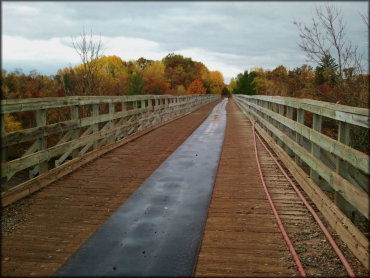
Photo Submitted 6/21/2016 (Thanks!)
St. Croix State Forest Trail Photo
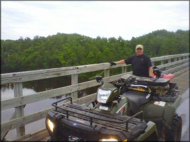
Photo Submitted 7/9/2011 (Thanks!)
ADD PHOTOS
TERRAIN
| Approx Size | 34,000 acres (53 sq mi) | |
| Miles Of Trail | 26 | |
| Climate Type | Forest | |
| Elevation | 950 to 1000 ft. | |
| Trail Maintenance | Not Marked, Not Rated, Lightly Maintained | |
| Loose Dirt |  Little Little | |
| Hard Pack |  Mostly Mostly | |
| Sand |  None None | |
| Mud |  Some Some | |
| Dust | Little | |
| Rocks | Little | |
| Trees |  All All | |
| Steep Hills | None | |
| Water Crossings |  Few Few | |
| Small Jumps | Few | |
| Large Jumps | None | |
| Berms | None | |
| Sand/Gravel Pits | None | |
| Single Track | None | |
| Roads | Some | |
| Shade |  Many Many | |
| Hazards | Few | (hazards assumed marked but use caution) |
 Novice Novice | Some | |
 Amateur Amateur | Mostly | |
 Expert Expert | Little |
GPS POINTS

KEY SERVICES
 Gasoline Gasoline | 20-30 Miles (NW) | Citgo (320) 245-5309 |
| Diesel | 20-30 Miles (NW) | Victory (320) 245-0081 |
 Water Water | On Site | Boulder Campground |
 RV Hookup RV Hookup | 1-5 Miles (SW) | St. Croix Haven Campground (320) 655-7989 |
 RV Disposal RV Disposal | 1-5 Miles (SW) | St. Croix Haven Campground (320) 655-7989 |
| Campground | On Site | Boulder Campground (320) 84-6591 |
 Conv Store Conv Store | 20-30 Miles (NW) | Duxbury Store (320) 245-2517 |
RIDER COMMENTS & REVIEWS