 |
      |
| Home > Minnesota > Nemadji State Forest |
Nemadji State Forest
Saturday, December 23, 2023
| Other Names | Iron Pipe Trail, Yellow Birch Trail, Birch Ridge Trail, Klondike Trail, Gandy Dancer Trail, Bearhunter Trail, State Line Creek, Little Net River, Westholm Creek, Mud Lake, Pickerel Lake, Willow River, Wolf Lake, Delong Lake, Duquette Run Trail, Continental Divide Trail, Bald Eagle Trail, Hinkle Creek, Cranberry Lake, Upper Willow Loop |
| Last Known Status | Open |
This state forest offers about 100 miles of ATV trails, which includes about 27 miles of single track trails for motorcycles only. Trails wind through a dense forest that consists of rolling hills, scattered swamps plus numerous creek and stream crossings.
You can thank the Straight Arrows Enduro Club for maintaining this trail system.
REGULATIONS
| Permit Required | Yes | MN OHV Permit |
| Dates Open | Year-Round except during spring thaw & deer hunting season. Designated snowmobile trails are closed to OHV use Dec 1 - March 31. | |
| Other ATV Stickers Accepted | Unknown | |
| Spark Arrestor | Yes | A spark arresting exhaust silencer or end cap is required for all vehicles. |
| Noise Limit | Yes (96 dB) | OHMs not to exceed distance of 20 inches, ATVs 99dB at 20 inches |
| Whip Flags | Not Required | |
| Maximum Vehicle Width | No Restriction | |
 Motorcycles & Dirt Bikes Motorcycles & Dirt Bikes | Permitted | |
 ATVs ATVs | Permitted | |
 UTV & SXS UTV & SXS | Permitted | |
 SUVs & Jeeps (registered) SUVs & Jeeps (registered) | Permitted | |
| Dune Buggy & Sand Rail 4x4 (unregistered) | Permitted | |
| 2 Stroke Engines | No Restriction | |
| MX Helmet Required | Youth Only | required for operators under 18 by state law (RiderPlanet strongly recommends helmets for all riders.) |
 Camping Camping | Some Areas | (camp in developed sites only) |
 Campfires Campfires | ||
| Night Riding | Unknown | |
| Trail Blazing | Prohibited | vehicles must stay on trail |
| Rule Enforcement |
TERRAIN
| Approx Size | 96,270 acres (150 sq mi) | |
| Miles Of Trail | 100 | |
| Climate Type | Forest | |
| Elevation | 1000 to 1200 ft. | |
| Trail Maintenance | Marked, Not Rated, Heavily Maintained | |
| Loose Dirt |  Little Little | |
| Hard Pack |  Some Some | |
| Sand |  None None | |
| Mud | Some | |
| Dust | Little | |
| Rocks | Little | |
| Trees |  All All | |
| Steep Hills |  Few Few | |
| Small Jumps | None | |
| Large Jumps | None | |
| Berms | Some | |
| Sand/Gravel Pits | None | |
| Single Track |  Many Many | |
| Hazards | Few | (hazards assumed marked but use caution) |
 Novice Novice | Some | |
 Amateur Amateur |  Mostly Mostly | |
 Expert Expert | Little |
TYPE OF AREA
| Area | Motorized Trails |
| Land | State Forest |


KEY SERVICES
 Gasoline Gasoline | 20-30 Miles (W) | Holiday Stationstores (218) 485-8827 |
| Diesel | 20-30 Miles (W) | Holiday Stationstores (218) 485-8827 |
 Water Water | On Site | |
 RV Hookup RV Hookup | 20-30 Miles (W) | Red Fox Campground and RV Park (218) 485-0341 |
 RV Disposal RV Disposal | 20-30 Miles (W) | Red Fox Campground and RV Park (218) 485-0341 |
| Campground | 1-5 Miles (N) | Gafvert Campground & Day Use Area |
 Conv Store Conv Store | 20-30 Miles (W) | Market Place Foods (218) 485-4336 |
FEES & PASSES
| Parking | (None) |
| Entry | (None) |
| Riding | (None) |
| Camping | (None) |
RATINGS
| Our Rating |  Good Good |
| Recommended Stay | Full Day |
| Comments | (Scroll Down For Rider Reviews & Comments) |
DRIVING DIRECTIONS
| Nearest City | Nickerson, MN | ||
| From: St. Paul, MN
1) Take I-35 North to Exit 195 2) Turn right (east) off the ramp on SR-23, continue 25 miles 3) Turn right (south) on CR-146, continue .3 miles 4) Turn left (east) at the T-intersection on Net Lake Road, continue 1.1 miles 5) Turn right (south) to stay on Net Lake Road, continue 3.5 miles 6) Staging area is on the left (north). |


OFFICIAL CONTACTS
| Contact Info | Nemadji State Forest - Moose Lake Area Office (218) 485-5410 (218) 485-5420 info.dnr@state.mn.us www.dnr.state.mn.us |
| Contact Info | Straight Arrow Enduro Riders club-officers@straightarrows.org www.straightarrows.org |
| Contact Info | Minnesota DNR License Bureau 500 Lafayette Road St. Paul, MN 55155 (888) 665-4236 aohfmnwebmaster@activenetwork.com www.dnr.state.mn.us |
| Comment | OHV Permit Info |
Nemadji State Forest Trail Photo
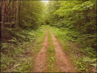
Photo Submitted 7/9/2011 (Thanks!)
Nemadji State Forest Trail Photo
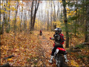
Photo Submitted 3/15/2013 (Thanks!)
Nemadji State Forest Trail Photo
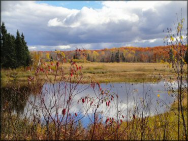
Photo Submitted 3/15/2013 (Thanks!)
Nemadji State Forest Trail Photo
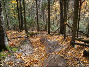
Photo Submitted 3/15/2013 (Thanks!)
RIDER COMMENTS & REVIEWS