 |
      |
| Home > Utah > Casto Canyon Trail |
Casto Canyon Trail
Saturday, December 23, 2023
| Other Names | Dixie National Forest, Losee Canyon, Barney Cove, Casto Wash, Costo Springs |
| Last Known Status | Open |
The Casto Canyon Trail offers scenic views of red hoodoos, colorful sandstone cliffs and scattered ponderosa pines. The main staging area has plenty of room for parking, an informational kiosk, a loading ramp plus a vault toilet.
The trail is limited to machines that are 50 inches or less in width. The trail is a great starting point to access the Barney Cove, Fremont and Paiute ATV trail. Nearby Losee Canyon is off limits to OHV use.
Overnight parking is prohibited at the main staging area but lodging and camping can be found a few miles away near Panguitch along Hwy 89 and the Red Canyon Area along Hwy 12.
REGULATIONS
| Permit Required | Yes | UT OHV sticker required |
| Dates Open | Year-Round | |
| Other ATV Stickers Accepted | No | Non-residents must purchase a non-resident OHV permit. |
| Spark Arrestor | Yes | A spark arresting exhaust silencer or end cap is required for all vehicles. |
| Noise Limit | Yes | |
| Whip Flags | Not Required | |
| Maximum Vehicle Width | Yes (50 inches) | has entrance gate or posts |
 Motorcycles & Dirt Bikes Motorcycles & Dirt Bikes | Permitted | |
 ATVs ATVs | Permitted | (maximum width 50 inches) |
 UTV & SXS UTV & SXS | Permitted | (maximum width 50 inches) |
 SUVs & Jeeps (registered) SUVs & Jeeps (registered) | Prohibited | |
| Dune Buggy & Sand Rail 4x4 (unregistered) | Prohibited | |
| 2 Stroke Engines | Some Areas | |
| MX Helmet Required | Youth Only | required for persons under 18 by state law (RiderPlanet strongly recommends helmets for all riders.) |
 Camping Camping | Prohibited | |
 Campfires Campfires | Prohibited | |
| Night Riding | Unknown | |
| Trail Blazing | Prohibited | stay on trails |
| Alcohol | No Restriction | |
| Rule Enforcement | Few/Periodic | |
| Comment | No specific decibel limit but excessive mechanical noise is prohibited. | |
TERRAIN
| Approx Size | 6,400 acres (10 sq mi) | |
| Miles Of Trail | 5 | |
| Climate Type | Forest | |
| Elevation | 7000 to 8000 ft. | |
| Trail Maintenance | Marked, Not Rated, Not Maintained | |
| Loose Dirt |  Little Little | |
| Hard Pack |  Some Some | |
| Mud | Little | |
| Dust | Some | |
| Rocks | Some | |
| Trees | Some | |
| Steep Hills |  Few Few | |
| Water Crossings | Few | |
| Sand/Gravel Pits |  None None | |
| Roads | None | |
| Intersections | Some | |
| Rider Traffic | Some | |
| Shade | Some | |
| Ranges/Gunfire | Few | |
| Hazards | Few | (hazards assumed marked but use caution) |
 Novice Novice | Some | |
 Amateur Amateur |  Mostly Mostly | |
 Expert Expert | Little |
TYPE OF AREA
| Area | Motorized Trails |
| Land | National Forest |


KEY SERVICES
 Gasoline Gasoline | 5-20 Miles (NW) | Panguitch |
| Diesel | 5-20 Miles (NW) | Panguitch |
 Water Water | 1-5 Miles (S) | Red Canyon RV Park (435) 676-2690 |
 RV Hookup RV Hookup | 1-5 Miles (S) | Red Canyon RV Park (435) 676-2690 |
 RV Disposal RV Disposal | 1-5 Miles (S) | Red Canyon RV Park (435) 676-2690 |
| Campground | 1-5 Miles (S) | Red Canyon RV Park (435) 676-2690 |
 Conv Store Conv Store | 1-5 Miles (S) | Red Canyon Service Station (435) 676-2690 |
FEES & PASSES
| Parking | (None) |
| Entry | (None) |
| Riding | (None) |
| Camping | (None) |
| Comment | Camping is prohibited at the main staging area. |
RATINGS
| Pros | colorful scenic views of red hoodoos & sand stone cliffs, free, connects to other ATV trails |
| Cons | camping prohibited, no services |
| Our Rating |  Very Good Very Good |
| Recommended Stay | Full Day Spring |
| Comments | (Scroll Down For Rider Reviews & Comments) |
DRIVING DIRECTIONS
| Nearest City | Panguitch, UT | ||
| Address | Casto Canyon Road, Panguitch, UT 84759 | ||
| From: Panguitch, UT
1) Take Hwy 89 south about 4 miles 2) Turn left (east) on Casto Canyon Road 3) Veer left at fork 4) Continue about 4 miles to the main staging area. |

OFFICIAL CONTACTS
| Contact Info | Dixie National Forest - Powell Ranger District P.O. Box 80 Panguitch, UT 84759-0080 (435) 676-9300 mailroom_r4_dixie@fs.fed.us www.fs.usda.gov |
| Contact Info | Red Canyon Visitor Center (435) 676-2676 |
| Contact Info | Utah OHV Permit Info 1594 W North Temple, Suite 116 Salt Lake City, UT 84116 (800) 648-7433 ohveducation@utah.gov stateparks.utah.gov |
Casto Canyon Trail Photo
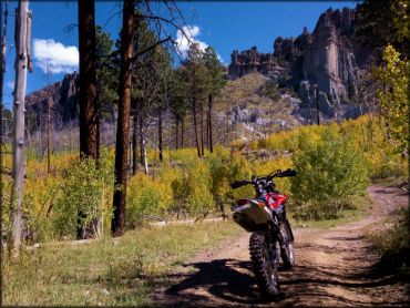
Photo Submitted 8/20/2015 (Those were some great shots, Thanks!)
Casto Canyon Trail Photo
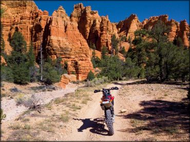
Photo Submitted 8/20/2015 (Thanks!)
Casto Canyon Trail Photo
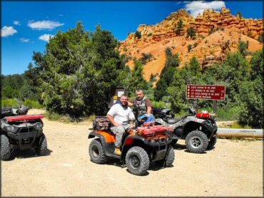
Photo Submitted 9/14/2011 (Thanks!)
Casto Canyon Trail Photo
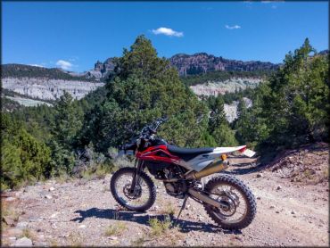
Photo Submitted 8/20/2015 (Thanks!)
Casto Canyon Trail Photo
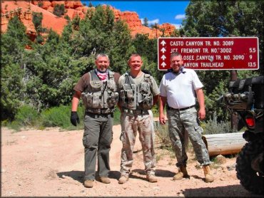
Photo Submitted 1/4/2015 (Thanks!)
RIDER COMMENTS & REVIEWS