 |
      |
| Home > West Virginia > Little Coal River |
Little Coal River ATV Trails
Saturday, December 23, 2023
| Other Names | Hatfield Mccoy Trails |
| Last Known Status | Open |
This area at one time was part of the Hatfield-McCoy Trail System but is now privately owned. The trails are still open for riding and ATVs, UTVs and dirt bikes are permitted. There is no fee charged to ride.
REGULATIONS
| Permit Required | Yes | Hatfield-McCoy Trail Permit |
| Dates Open | Year-Round | |
| Spark Arrestor | Yes | A spark arresting exhaust silencer or end cap is required for all vehicles. |
| Noise Limit | Yes (99 dB) | |
| Whip Flags | Not Required | |
| Maximum Vehicle Width | No Restriction | |
 Motorcycles & Dirt Bikes Motorcycles & Dirt Bikes | Permitted | |
 Four Wheelers Four Wheelers | Permitted | |
 UTV & SXS UTV & SXS | Permitted | |
 4x4 & Jeeps (registered) 4x4 & Jeeps (registered) | Prohibited | |
| Dune Buggy & Sand Rail 4x4 (unregistered) | Prohibited | |
| 2 Stroke Engines | No Restriction | |
| MX Helmet Required | Yes | |
 Camping Camping | Prohibited | camping not permitted on trail system or at staging areas |
 Campfires Campfires | Prohibited | |
| Night Riding | No | riding hours are from sunrise to sunset |
| Trail Blazing | Prohibited | stay on trail |
| Alcohol | Prohibited | |
| Rule Enforcement | Yes | Dedicated Rangers/Officers Armed OfficersJeep/SUV Patrol |
Advertisement
TYPE OF AREA
| Area | Motorized Trails |
| Land | Privately Owned / Commercial |
FEES & PASSES
| Parking | (None) |
| Entry | (None) |
| Riding | (None) |
| Camping | (None) |
RATINGS
| Our Rating |  Excellent Excellent |
| Recommended Stay | Multi Week |
| Comments | (Scroll Down For Rider Reviews & Comments) |
DRIVING DIRECTIONS
| Nearest City | Charleston, WV | ||
| Address | 28 Big Pinnacle Branch Road, Julian, WV 25529 | ||
| From: Charleston, WV
1) Take US-119 south about 19 miles 2) Turn left (east) on Big Pinnacle Creek Road 3) Proceed toward the staging area. |


OFFICIAL CONTACTS
Little Coal River Trail Photo
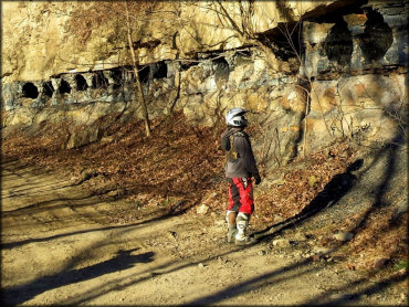
Photo Submitted 7/25/2018 (Thanks!)
ADD PHOTOS
TERRAIN
| Approx Size | 10,880 acres (17 sq mi) | |
| Miles Of Trail | 60 | |
| Climate Type | Forest | |
| Elevation | 650 to 1200 ft. | |
| Trail Maintenance | Marked, Rated, Heavily Maintained | |
| Single Track |  Few Few | |
| Hazards | Few | (hazards assumed marked but use caution) |
 Novice Novice |  Mostly Mostly | |
 Amateur Amateur |  Some Some | |
 Expert Expert |  Little Little |
GPS POINTS


KEY SERVICES
 Gasoline Gasoline | 1-5 Miles (SW) | Whitten's Feed & Seed/Exxon (304) 524-2483 |
| Diesel | 1-5 Miles (SW) | Whitten's Feed & Seed/Exxon (304) 524-2483 |
 Water Water | 1-5 Miles (W) | Little Coal River Campground (304) 369-1951 |
 RV Hookup RV Hookup | 1-5 Miles (W) | Little Coal River Campground (304) 369-1951 |
 RV Disposal RV Disposal | 1-5 Miles (W) | Little Coal River Campground (304) 369-1951 |
| Campground | 1-5 Miles (W) | Little Coal River Campground (304) 369-1951 |
 Conv Store Conv Store | 1-5 Miles (S) | Julian Mini-Mart (304) 369-6480 |
RIDER COMMENTS & REVIEWS