 |
      |
| Home > Nevada > Pahrump |
Pahrump
Wednesday, September 17, 2025
| Other Names | Parump, Spring Mountains National Recreation Area, Humboldt Toiyabe National Forest, Mt. Sterling, Cold Creek, Wheeler Pass, Nye County, Tecopa Charcoal Ovens, Wheeler Wells |
| Last Known Status | Open |
This large area features miles of desert trails that tie into the neighboring area of Cold Creek. The terrain is a nice mix of hard pack, sand and gravel washes plus rocky double track that wind through various sage and scrub brush at lower elevations and juniper/bristlecone pine forest at higher elevations.
One of the main highlights is the main 4x4 trail known as Wheeler Pass heads north and eventually passes by the Tecopa Charcoal Ovens which was built back in 1875. The trails are open year-round but the best time to visit is during the spring and fall months. During winter months expect snow covered conditions the higher you climb in elevation.
Services in town, including several RV parks, are in close proximity. Established primitive trail heads available but for those looking for designated campgrounds try McWilliams and Fletcher View Campgrounds. Both offer shaded RV sites but no direct offroad access to the OHV trails.
REGULATIONS
| Permit Required | Yes | NVOHV sticker required |
| Dates Open | Year-Round | |
| Other ATV Stickers Accepted | Yes | Nevada registration is not required if the vehicle is already registered in another state and will be located in Nevada for no more than 15 days. |
| Spark Arrestor | Yes | A spark arresting exhaust silencer or end cap is required for all vehicles. |
| Noise Limit | Yes (96 dB) | |
| Whip Flags | Not Required | |
| Maximum Vehicle Width | No Restriction | |
 Motorcycles & Dirt Bikes Motorcycles & Dirt Bikes | Permitted | |
 ATVs ATVs | Permitted | |
 UTV & SXS UTV & SXS | Permitted | |
 SUVs & Jeeps (registered) SUVs & Jeeps (registered) | Permitted | |
| Dune Buggy & Sand Rail 4x4 (unregistered) | Permitted | |
| 2 Stroke Engines | No Restriction | |
 Camping Camping | Some Areas | |
 Campfires Campfires | Some Areas | seasonal fire restrictions may apply |
| Night Riding | Unknown | |
| Trail Blazing | Prohibited | keep on the trail |
| Alcohol | No Restriction | |
| Rule Enforcement | Few/Periodic | Jeep/SUV Patrol |
TYPE OF AREA
| Area | Motorized Trails |
| Land | BLM, National Forest |
FEES & PASSES
| Parking | (None) |
| Entry | (None) |
| Riding | (None) |
| Camping | (None) |
RATINGS
| Our Rating |  Good Good |
| Recommended Stay | Full Day |
| Comments | (Scroll Down For Rider Reviews & Comments) |
DRIVING DIRECTIONS
| Nearest City | Pahrump, NV | ||
| Address | Wheeler Pass Road, Las Vegas, NV 89124 | ||
| From: Pahrump, NV
1) Take Wheeler Pass Road east about 10 miles. |


OFFICIAL CONTACTS
| Contact Info | Humboldt - Toiyabe National Forest - Spring Mountains NRA 4701 North Torrey Pines Drive Las Vegas, NV 89130 (702) 515-5400 mailroom_r4_humboldt_toiyabe@fs.fed.us www.fs.usda.gov |
Pahrump Trail Photo
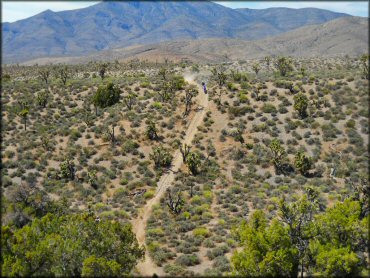
Photo Submitted 9/9/2011 (Thanks!)
Pahrump Trail Photo
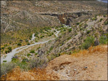
Photo Submitted 9/9/2011 (Thanks!)
Pahrump Trail Photo
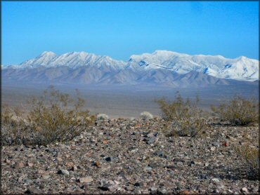
Photo Submitted 9/9/2011 (Thanks!)
ADD PHOTOS
TERRAIN
| Approx Size | 12,800 acres (20 sq mi) | |
| Miles Of Trail | 20 | |
| Climate Type | Desert | |
| Elevation | 2500 to 7000 ft. | |
| Trail Maintenance | Marked, Not Rated, Lightly Maintained | |
| Loose Dirt |  Little Little | |
| Hard Pack |  Mostly Mostly | |
| Sand |  Some Some | |
| Mud |  None None | |
| Dust | Some | |
| Rocks | Some | |
| Trees | Some | |
| Steep Hills |  Many Many | |
| Berms | Some | |
| Single Track | Some | |
| Roads | Some | |
| Intersections |  Few Few | |
| Rider Traffic | Few | |
| Shade | Few | |
| Ranges/Gunfire | Few | |
| Hazards | Few | (hazards assumed marked but use caution) Beware of open mine shafts, nearby bombing ranges, cliffs. |
 Novice Novice | Some | |
 Amateur Amateur | Mostly | |
 Expert Expert | Little |


KEY SERVICES
 Gasoline Gasoline | 1-5 Miles (SW) | Terribles/Chevron (775) 751-7711 |
| Diesel | 1-5 Miles (SW) | Terribles/Chevron (775) 751-7711 |
 Water Water | 1-5 Miles (SW) | Preferred RV Resort (775) 727-4414 or (800) 445-7840 |
 RV Hookup RV Hookup | 1-5 Miles (SW) | Preferred RV Resort (775) 727-4414 or (800) 445-7840 |
 RV Disposal RV Disposal | 1-5 Miles (SW) | Preferred RV Resort (775) 727-4414 or (800) 445-7840 |
| Campground | 5-20 Miles (NE) | McWilliams Campground (702) 872-5577 |
 Conv Store Conv Store | 1-5 Miles (SW) | Terribles/Chevron (775) 751-7711 |
RIDER COMMENTS & REVIEWS