 |
      |
| Home > Nevada > Cold Creek |
Cold Creek
Wednesday, September 17, 2025
| Other Names | Humboldt Toiyabe National Forest, Wheeler Pass, Wheeler Wells, Spring Mountains |
| Last Known Status | Open |
This remote area is open to all vehicle types and offers miles of 4x4 roads and trails that wind through the rugged Spring Mountains. The main staging area has plenty of space for parking but there are no shade or services so bring your own supplies. A couple shallow ponds border the parking area and is frequented by wild mustangs.
The trails head west and eventually tie into the Pahrump area, which has more desert roads and loops to explore. The terrain is mostly rugged hard pack but has some sand and gravel washes with moderate elevation climbs. Vegetation is a mix of Joshua Trees and scrub brush on the desert floor and juniper and bristle cone trees at higher elevations.
This area is open year-round and is usually crowd free during the week. Expect regular and three day holiday weekends to be busy.
REGULATIONS
| Permit Required | Yes | NVOHV sticker required |
| Dates Open | Year-Round | |
| Other ATV Stickers Accepted | Yes | Nevada registration is not required if the vehicle is already registered in another state and will be located in Nevada for no more than 15 days. |
| Spark Arrestor | Yes | A spark arresting exhaust silencer or end cap is required for all vehicles. |
| Noise Limit | Yes (96 dB) | |
| Whip Flags | Not Required | |
| Maximum Vehicle Width | No Restriction | |
 Motorcycles & Dirt Bikes Motorcycles & Dirt Bikes | Permitted | |
 ATVs ATVs | Permitted | |
 UTV & SXS UTV & SXS | Permitted | |
 SUVs & Jeeps (registered) SUVs & Jeeps (registered) | Permitted | |
| Dune Buggy & Sand Rail 4x4 (unregistered) | Permitted | |
| 2 Stroke Engines | No Restriction | |
 Camping Camping | No Restriction | (camp anywhere) |
 Campfires Campfires | ||
| Night Riding | Unknown | |
| Trail Blazing | Prohibited | stay on trails |
| Rule Enforcement |
TERRAIN
| Miles Of Trail | 20 | |
| Climate Type | Desert | |
| Elevation | 5500 to 9100 ft. | |
| Trail Maintenance | Marked, Not Rated, Lightly Maintained | |
| Loose Dirt |  Little Little | |
| Hard Pack |  Mostly Mostly | |
| Sand |  Some Some | |
| Mud | Little | |
| Dust | Some | |
| Rocks | Some | |
| Trees | Some | |
| Steep Hills | Some | |
| Water Crossings |  None None | |
| Small Jumps | None | |
| Large Jumps | None | |
| Berms | None | |
| Sand/Gravel Pits | None | |
| Single Track | None | |
| Roads | Mostly | |
| Shade |  Few Few | |
| Hazards | Few | (hazards assumed marked but use caution) |
 Novice Novice | Some | |
 Amateur Amateur | Mostly | |
 Expert Expert | Little |
TYPE OF AREA
| Area | Motorized Trails |
| Land | National Forest |


KEY SERVICES
 Gasoline Gasoline | 5-20 Miles (NE) | Shell (702) 879-3567 |
| Diesel | 5-20 Miles (NE) | Shell (702) 879-3567 |
 Water Water | 30+ Miles | McWilliams Campground (702) 515-5400 |
 RV Hookup RV Hookup | 30+ Miles | Fletcher View Campground (702) 872-5577 |
 RV Disposal RV Disposal | Las Vegas, NV | |
| Campground | 30+ Miles | McWilliams Campground (702) 515-5400 |
 Conv Store Conv Store | 20-30 Miles (NE) | Shell (702) 879-3567 |
FEES & PASSES
| Parking | (None) |
| Entry | (None) |
| Riding | (None) |
| Camping | (None) |
RATINGS
| Our Rating |  Good Good |
| Recommended Stay | 1-2 Days |
| Comments | (Scroll Down For Rider Reviews & Comments) |
DRIVING DIRECTIONS
| Nearest City | Las Vegas, NV | ||
| Address | Cold Creek Road, Las Vegas, NV 89124 | ||
| From: Las Vegas, NV
1) Take US-95 North about 35 miles 2) Turn left (west) onto Cold Creek Road, continue about 13 miles (look for the prisons, turn here) 3) Staging area is on the right (north). |


OFFICIAL CONTACTS
| Contact Info | Humboldt - Toiyabe NF - Spring Mountains NRA 4701 North Torrey Pines Drive Las Vegas, NV 89130-2301 (702) 515-5400 mailroom_r4_humboldt_toiyabe@fs.fed.us www.fs.usda.gov |
Cold Creek Trail Photo
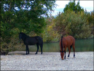
Photo Submitted 10/2/2011 (Thanks!)
Cold Creek Trail Photo
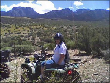
Photo Submitted 9/17/2012 (Thanks!)
Cold Creek Trail Photo
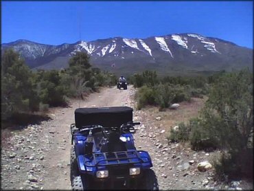
Photo Submitted 9/17/2012 (Thanks!)
Cold Creek Trail Photo
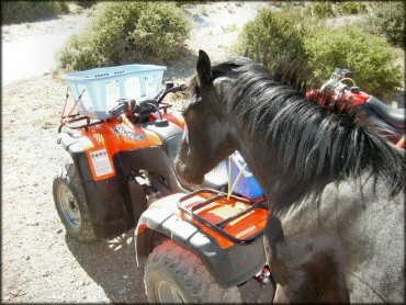
Submitted Photo (7/1/2011) Thanks!
RIDER COMMENTS & REVIEWS