 |
      |
| Home > Alabama > Atmore Motox Park |
Atmore Motox Park
Saturday, May 10, 2025
| Other Names | Atmore MX Park, Atmore Moto X Park |
| Last Known Status | Closed |
This park at one time offered a main and a pee-wee track but is closed and no longer open for riding. The main track was wide and over a mile long featuring natural elevation changes and regular grooming. There is a 75' triple and a 65' double as well as some table tops and small doubles.
REGULATIONS
| Permit Required | No | |
| Dates Open | Closed | |
| Spark Arrestor | Recommended | A spark arresting exhaust silencer or end cap is recommended. |
| Noise Limit | ||
| Whip Flags | Not Required | |
| Maximum Vehicle Width | ||
 Motorcycles & Dirt Bikes Motorcycles & Dirt Bikes | Prohibited | |
 ATVs ATVs | Prohibited | |
 UTV & SXS UTV & SXS | Prohibited | |
 SUVs & Jeeps (registered) SUVs & Jeeps (registered) | Prohibited | |
| Dune Buggy & Sand Rail 4x4 (unregistered) | Prohibited | |
| 2 Stroke Engines | Prohibited | |
 Camping Camping | ||
 Campfires Campfires | ||
| Night Riding | No | |
| Trail Blazing | Prohibited | |
| Rule Enforcement |
Advertisement
TYPE OF AREA
| Area | MX Track |
| Land | Privately Owned / Commercial |
MX TRACK 
| Features | Public |
| Max Engine Size | No Maximum |
| Min Engine Size | No Minimum |
FEES & PASSES
| Parking | (None) |
| Entry | (None) |
| Riding | Yes ($20.00 per OHV) |
| Camping | (None) |
RATINGS
| Our Rating |  |
| Recommended Stay | Full Day |
| Comments | (Scroll Down For Rider Reviews & Comments) |
DRIVING DIRECTIONS
| Nearest City | Atmore, AL | ||
| Address | 1022 Hope Grant Road, Atmore, AL 36502 | ||
| From: Mobile, AL
1) I-65 North to Exit 57 (AL-21 exit) 2) Turn left off ramp on AL-21, continue 3.4 miles (go past Atmore Prison) 3) Turn right on Ross Gate Road, continue 3 miles to end of road 4) Turn right on CR-45, continue 0.5 miles 5) Turn left on Hope Grant Road, continue 0.7 miles 6) Entrance gate is straight ahead. |


OFFICIAL CONTACTS
Atmore Motox Park Track Photo
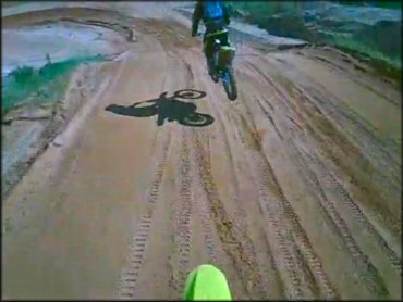
Photo Submitted 12/29/2012 (Thanks!)
ADD PHOTOS
TERRAIN
| Approx Size | 32 acres | |
| Miles Of Trail | 2 | |
| Climate Type | Urban/man-made | |
| Elevation | 285 to 300 ft. | |
| Loose Dirt |  Some Some | |
| Hard Pack | Some | |
| Sand |  Mostly Mostly | track has a sand base and handles water well |
| Mud |  Little Little | |
| Dust | Some | |
| Rocks |  None None | |
| Trees |  Many Many | |
| Steep Hills | None | |
| Water Crossings | None | |
| Small Jumps | Many | |
| Large Jumps | Some | |
| Berms |  All All | |
| Sand/Gravel Pits | None | |
| Single Track | None | |
| Roads | None | |
| Rider Traffic |  Few Few | |
| Shade | Some | there are shade trees in the pit area |
| Ranges/Gunfire | None | |
| Hazards | Few | (hazards are marked) |
 Novice Novice | Little | |
 Amateur Amateur | Mostly | |
 Expert Expert | Little |
GPS POINTS


KEY SERVICES
 Gasoline Gasoline | 1-5 Miles (SW) | BP Gas Station (251) 368-3587 |
| Diesel | 1-5 Miles (SW) | BP Gas Station (251) 368-3587 |
 Water Water | 1-5 Miles (SE) | Magnolia Branch Wildlife Reserve and Campground (251) 446-3423 |
 RV Hookup RV Hookup | 1-5 Miles (SE) | Magnolia Branch Wildlife Reserve and Campground (251) 446-3423 |
 RV Disposal RV Disposal | 1-5 Miles (SE) | Magnolia Branch Wildlife Reserve and Campground (251) 446-3423 |
| Campground | 1-5 Miles (SE) | Magnolia Branch Wildlife Reserve and Campground (251) 446-3423 |
 Conv Store Conv Store | 1-5 Miles (SW) | BP Gas Station (251) 368-3587 |
RIDER COMMENTS & REVIEWS