 |
      |
| Home > Arkansas > Sugar Creek Trail |
Sugar Creek Trail
Tuesday, August 19, 2025
| Other Names | Sugar Creek, Ouachita National Forest, Cold Springs Ranger District, Jack Creek Recreation Area, Huckleberry Creek, Middle Creek, Bald Knob, Spanish Oak Ridge, Buck Ridge, Right Hand Sugar Creek, Knoppers Ford |
| Last Known Status | Open |
Open year-round, this area offers 37 miles hard packed and rocky ATV trails with several creek crossings. The trails are marked with yellow blazes and form long and scenic loops. The trail system is open year-round but note that trail 13 (heading west from the staging area) has a seasonal crossing that is only accessible during dry weather.
There is no fee charged for parking or riding but overnight parking is not permitted at the main staging. Knoppers Ford is less about a half mile away which has six tent sites and a vault toilet and additional camping can be found a few miles north at Jack Creek Campground. Both sites do not charge for camping or day use but there are no electric or water hookups, so come prepared.
REGULATIONS
| Permit Required | No | |
| Dates Open | Year-Round | |
| Other ATV Stickers Accepted | Unknown | |
| Spark Arrestor | Yes | A spark arresting exhaust silencer or end cap is required for all vehicles. |
| Noise Limit | Yes (96 dB) | |
| Whip Flags | Not Required | |
| Maximum Vehicle Width | Yes (64 inches) | has entrance gate or posts |
 Motorcycles & Dirt Bikes Motorcycles & Dirt Bikes | Permitted | |
 ATVs ATVs | Permitted | |
 UTV & SXS UTV & SXS | Permitted | (maximum width 64 inches) |
 SUVs & Jeeps (registered) SUVs & Jeeps (registered) | Prohibited | |
| Dune Buggy & Sand Rail 4x4 (unregistered) | Prohibited | |
| 2 Stroke Engines | No Restriction | |
| MX Helmet Required | No | (RiderPlanet strongly recommends helmets for all riders.) |
 Camping Camping | Some Areas | (camp in developed sites only) |
 Campfires Campfires | Some Areas | (permitted in developed campsites only) |
| Night Riding | Unknown | |
| Trail Blazing | Prohibited | vehicles must stay on trail |
| Rule Enforcement | ||
| Comment | Arkansas residents are required to register all 3 and 4-wheeled OHVs with the AR Department of Revenue. Decal is not a forest pass, it fulfills state requirements only. Arkansas residents can call their county revenue department for more information. | |
TERRAIN
| Miles Of Trail | 37 | |
| Climate Type | Forest | |
| Elevation | 750 to 1000 ft. | |
| Trail Maintenance | Marked, Not Rated, Lightly Maintained | trails are marked with yellow rectangles |
| Loose Dirt |  Some Some | |
| Hard Pack |  Mostly Mostly | |
| Sand |  None None | |
| Mud |  Little Little | |
| Dust | Little | |
| Rocks | Some | |
| Trees |  All All | |
| Steep Hills |  Few Few | |
| Water Crossings | Some | |
| Small Jumps | None | |
| Large Jumps | None | |
| Berms | None | |
| Sand/Gravel Pits | None | |
| Single Track | None | |
| Roads | None | |
| Shade | Some | |
| Hazards | Few | (hazards assumed marked but use caution) |
 Novice Novice | Some | |
 Amateur Amateur | Mostly | |
 Expert Expert | Little |
TYPE OF AREA
| Area | Motorized Trails |
| Land | National Forest |


KEY SERVICES
 Gasoline Gasoline | 5-20 Miles (NW) | Jam Mart (479) 675-7030 |
| Diesel | 5-20 Miles (NW) | Jam Mart (479) 675-7030 |
 Water Water | 5-20 Miles (NE) | Waveland Park Campground (479) 947-2102 |
 RV Hookup RV Hookup | 5-20 Miles (NE) | Waveland Park Campground (479) 947-2102 |
 RV Disposal RV Disposal | 5-20 Miles (NE) | Waveland Park Campground (479) 947-2102 |
| Campground | On Site | Knoppers Ford Campground (501) 321-5305 |
 Conv Store Conv Store | 5-20 Miles (NW) | Jam Mart (479) 675-7030 |
FEES & PASSES
| Parking | (None) |
| Entry | (None) |
| Riding | (None) |
| Camping | (None) |
RATINGS
| Our Rating |  Good Good |
| Recommended Stay | Full Day |
| Comments | (Scroll Down For Rider Reviews & Comments) |
DRIVING DIRECTIONS
| Nearest City | Booneville, AR | ||
| From: Booneville, AR
1) Take SR-116 South about 2 miles 2) Turn left (south-east) on Hwy 116 East, continue 8 miles toward Knoppers Ford Recreation Area 3) Continue south past .5 miles past Knoppers Ford 4) Turn left (east) on Road S30, turn left, continue 1.25 miles toward staging area. |


OFFICIAL CONTACTS
| Contact Info | Ouachita National Forest - Cold Springs Office P.O. Box 417, 2190 E. Main Street Booneville, AR 72927 (479) 675-3233 sm.fs.onf-contact@usda.gov www.fs.usda.gov |
Sugar Creek Trail Photo
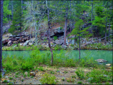
Photo Submitted 3/11/2013 (Thanks!)
Sugar Creek Trail Photo
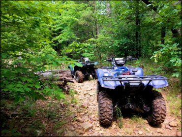
Photo Submitted 7/26/2016 (Thanks!)
Sugar Creek Trail Photo
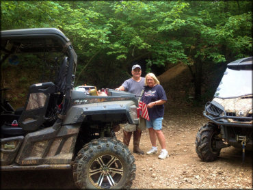
Photo Submitted 6/2/2017 (Thanks!)
Sugar Creek Trail Photo
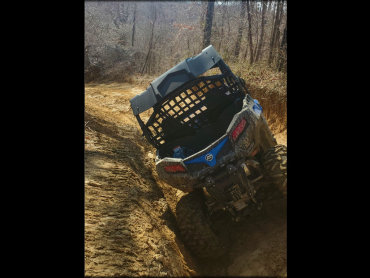
Photo Submitted 3/6/2022 (Thanks!)
Sugar Creek Trail Photo
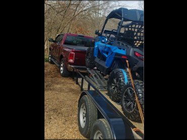
Photo Submitted 3/6/2022 (Thanks!)
RIDER COMMENTS & REVIEWS