 |
      |
| Home > California > Tinta Trail |
Tinta Trail
Monday, August 4, 2025
| Other Names | Los Padres National Forest, Ojai Ranger District, Tinta Creek, West Dry Canyon Road |
| Last Known Status | Open |
This part of the Los Padres National Forest offers a seven mile long single track trail that follows a scenic canyon that eventually ends at West Dry Canyon Road/NF 8N19.
The trail offers plenty of nice mountain views. The terrain is moderately challenging and mainly consists of hard packed soil with light to moderate elevation changes.
A small primitive campground is located at the base of the trail which offers several rustic tent sites. The trail is only open to hikers, mountain bikes and motorcycles.
REGULATIONS
| Permit Required | Yes | CA OHMVR stickers required |
| Dates Open | May 1 - November 1 | CA OHMVR red sticker vehicles permitted year round |
| Other ATV Stickers Accepted | Yes | Residents of any state not listed must purchase a Nonresident OHV Use Permit. (AR, AZ, CA, CO, CT, DE, IA, ID, IN, LA, MA, MD, ME, MI, MN, MO, MT, ND, NH, NJ, NM, NV, NY, OH, OK, OR, PA, RI, TX, UT, VT, WA, WI, WY) |
| Spark Arrestor | Yes | A spark arresting exhaust silencer or end cap is required for all vehicles. |
| Noise Limit | Yes (96 dB) | CA OHMVR noise limits apply (1985/older limit 101 dB, 1986/newer limit 96 dB) |
| Whip Flags | Not Required | |
| Maximum Vehicle Width | ||
 Motorcycles & Dirt Bikes Motorcycles & Dirt Bikes | Permitted | CA OHMVR stickers required |
 ATVs ATVs | Prohibited | CA OHMVR stickers required |
 UTV & SXS UTV & SXS | Prohibited | CA OHMVR stickers required |
 SUVs & Jeeps (registered) SUVs & Jeeps (registered) | Prohibited | |
| Dune Buggy & Sand Rail 4x4 (unregistered) | Prohibited | CA OHMVR stickers required |
| 2 Stroke Engines | No Restriction | CA OHMVR restrictions apply |
| MX Helmet Required | Yes | helmets required by state law |
 Camping Camping | Some Areas | (camp in developed sites only) |
 Campfires Campfires | Some Areas | (permitted in developed campsites only) |
| Night Riding | Unknown | |
| Trail Blazing | Prohibited | keep vehicle on trail |
| Rule Enforcement |
Advertisement
TYPE OF AREA
| Area | Motorized Trails |
| Land | National Forest |
FEES & PASSES
| Parking | Yes ($5.00) Adventure Pass Fee - $5/day or $30/year |
| Entry | (None) |
| Riding | (None) |
| Camping | (None) |
| Comment | C and H Market is the closest vendor that sells the Adventure Pass. Call (661) 766-2761 for store hours. |
RATINGS
| Our Rating |  Good Good |
| Recommended Stay | Full Day |
| Comments | (Scroll Down For Rider Reviews & Comments) |
DRIVING DIRECTIONS
| Nearest City | Ojai, CA | ||
| Address | Tinta Creek Road, Maricopa, CA 93252 | ||
| From: Ventura, CA
1) Take SR-33 North about 60 miles 2) Turn left (west) onto Rancho Nuevo Creek Road, continue about 1 mile 3) Trailhead is located at Tinta Campground. |


OFFICIAL CONTACTS
| Contact Info | Los Padres National Forest - Ojai Ranger District 1190 E. Ojai Ave. Oajai, CA 93023 (805) 646-4348 mailroom_r5_los_padres@fs.fed.us www.fs.usda.gov |
Tinta Trail Photo
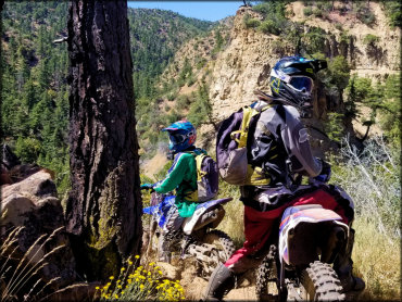
Photo Submitted 6/15/2020 (Thanks!)
ADD PHOTOS
TERRAIN
| Miles Of Trail | 7 | |
| Climate Type | Forest | |
| Elevation | 3650 to 4200 ft. | |
| Trail Maintenance | Marked, Not Rated, Lightly Maintained | |
| Loose Dirt |  Little Little | |
| Hard Pack |  Mostly Mostly | |
| Sand | Little | |
| Mud |  None None | |
| Dust |  Some Some | |
| Rocks | Little | |
| Trees |  Few Few | |
| Steep Hills | Some | |
| Water Crossings | None | |
| Small Jumps | None | |
| Large Jumps | None | |
| Berms |  Many Many | |
| Sand/Gravel Pits | None | |
| Single Track |  All All | |
| Roads | None | |
| Shade | Few | |
| Hazards | Few | (hazards assumed marked but use caution) |
 Novice Novice | Little | |
 Amateur Amateur | Mostly | |
 Expert Expert | Some |
GPS POINTS


KEY SERVICES
 Gasoline Gasoline | 20-30 Miles (NW) | C & H Market (661) 766-2761 |
| Diesel | 20-30 Miles (NW) | C & H Market (661) 766-2761 |
 Water Water | 5-20 Miles (S) | Wheeler Gorge Campground (805) 646-4348 |
 RV Hookup RV Hookup | 30+ Miles (SW) | Lake Casitas Recreation Area Campground (805) 649-2233 or (805) 649-1122 |
 RV Disposal RV Disposal | 30+ Miles (SW) | Lake Casitas Recreation Area Campground (805) 649-2233 or (805) 649-1122 |
| Campground | On Site | |
 Conv Store Conv Store | 20-30 Miles (NW) | C & H Market (661) 766-2761 |
RIDER COMMENTS & REVIEWS